
8th Street Culvert - Okemah, OK
Posted by:  hamquilter
N 35° 26.262 W 096° 18.591
14S E 744195 N 3924909
This culvert is located on N. 8th Street, between Erie and Frisco.
Waymark Code: WMYF14
Location: Oklahoma, United States
Date Posted: 06/07/2018
Views: 0
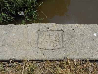
This culvert appears to handle water running through a two-block, man-made drainage ditch, just west of the WPA athletic stadium. The culvert runs east-west and is approximately 3 ft. high by 6 ft. wide. The culvert is constructed of large, cut blocks.
A WPA shield is stamped at either end, which reads 1939.
Project type: Other

Date built or created: 1939
City: Okemah, OK
Condition: Good upkeep with a little wear and tear
Location: Not listed
Website for additional information: Not listed
|
Visit Instructions:
To help give a different perspective and to better the waymark for future visitors please tell us about your visit and upload a favorite photograph you took of the waymark.
Although visiting this waymark in person is the only thing required of you to receive credit for your visit, taking the time to add this information is greatly appreciated.
Recent Visits/Logs:
| There are no logs for this waymark yet. |
|
|
|