
 It constitutes with the Peninsula of the Caravelle, the oldest witness of the geological formation of the island of Martinique.
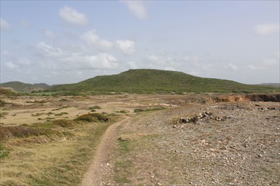
A stone's throw away from the famous Salines beach in Sainte-Anne, the savannah of petrification is a former dry swamp, itself set on the site of a very old volcano, the Morne des Petrifications which culminates at 119 Meters is one of the vestiges. The bare ground of this desert is littered with blocks of yellow, red or black polychrome jasper, giving the landscape an astonishing lunar aspect.
This ancient savannah owes its name to the curious tree trunks and the petrified (silicified) branches that once stood on the horizon and which have now disappeared, carried away by the collectors and the inhabitants of the surroundings. The savannah of the Petrifications is located on the shores of the sea and the Pointe de l'Enfer, and overlooks the Table du Diable, an enormous rock rising from the waves a few cables offshore and subject to many legends.
The savanna of the Petrification is one of the stages of the hike of the "Trace of the Caps", path that goes along the southern coast of Martinique and is a site classified by the Regional Natural Park of the island.
 Elle constitue avec la Presqu’île de la Caravelle, le témoin le plus ancien de la formation géologique de l’île de la Martinique.
A deux pas de la célèbre plage des Salines, sur la commune de Sainte-Anne, la savane des pétrifications est un ancien marais asséché, lui-même installé sur le site d’un très vieux volcan dont le Morne des Pétrifications qui culmine à 119 mètres est l’un des vestiges. La terre nue de ce désert est jonchée de blocs de jaspe polychrome jaune, rouge ou noir, donnant au paysage un étonnant aspect lunaire.
Cette ancienne savane doit son nom aux curieux troncs d’arbres et aux branches pétrifiés (silicifiés) qui se détachaient autrefois sur l’horizon et qui ont aujourd’hui disparus, emportés par les collectionneurs et les habitants des environs. Sur une dizaine d’hectares, la savane des Pétrifications jouxte la mer et la Pointe de l’Enfer et fait face à la Table du Diable un énorme rocher surgi des flots à quelques encablures au large et sujet de bien des légendes.
La savane des Pétrifications est l’une des étapes de la randonnée de la « Trace des Caps », sentier qui longe le littoral méridional de la Martinique et est un site classé par le Parc Naturel régional de l’ile.
Sources : La Savane des pétrifications