
Coffee Creek Culvert (4) - Oklahoma County, OK
Posted by:  hamquilter
N 35° 41.760 W 097° 15.548
14S E 657507 N 3951627
Keeping the Section Roads from flooding, these culverts provide a vital service to rural Oklahoma.
Waymark Code: WMXRQM
Location: Oklahoma, United States
Date Posted: 02/21/2018
Views: 0
This culvert on Coffee Creek Road is about one-half mile west of Indian Meridian Road. It would not be identifiable were it not for the yellow and black warning signs posted. The area is wooded, and there are homes on the north side of the road. A creek runs east-west near the north side of the road, and this culvert handles run-off during heavy rains. This location is about 2.5 miles north of Route 66 between the towns of Arcadia and Luther.
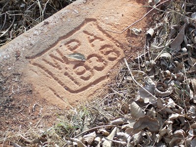
The tunnel is concrete and only about 24-30 inches high by perhaps 7 ft. wide. The WPA shield stamped in the concrete at first appears to read 1935, but upon closer inspection it is 1936.
Check out the web site below for a nice complete story of New Deal work in Oklahoma.