
Coffee Creek Culvert (2) - Oklahoma County, OK
Posted by:  hamquilter
N 35° 41.757 W 097° 15.891
14S E 656990 N 3951613
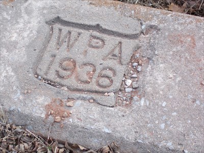
This WPA culvert serves a vital purpose in controlling water run-off in rural Oklahoma.
Waymark Code: WMXRQ9
Location: Oklahoma, United States
Date Posted: 02/21/2018
Views: 0
All along Coffee Creek Road, numerous culverts have been constructed to handle flooding, and keep the rural roads open for travel. As with most of these culverts, they go almost unnoticed as you travel through the area. Concrete curbing on each side of the road blends in with the grasses and leaves. A WPA shield is stamped at the center of each curb, many times covered with dirt, requiring some "uncover" work to expose the treasure.
This culvert is located on Coffee Creek Road, where Choctaw Road would have intersected if it wasn't interrupted at this point. It is located about 2.5 miles north of Route 66, northeast of the town of Arcadia, at the convergence of two unnamed creeks. On one side of the road, the culvert is about 3 ft. and 6 ft., and on the other side 2ft by 6 ft. The date 1936 is stamped on the curbing.
The link below will lead you to a complete story of the New Deal road projects during the 1930s.