
Parc national de Göreme et sites rupestres de Cappadoce - Göreme, Turkey
Posted by:  pmaupin
N 38° 38.242 E 034° 50.764
36S E 660673 N 4278152
[EN] The Goreme Valley is home to houses, troglodyte villages and rock sanctuaries.
[FR] La vallée de Göreme abrite des habitations, des villages troglodytiques et des sanctuaires rupestres.
Waymark Code: WMWWDB
Location: Türkiye
Date Posted: 10/22/2017
Views: 3

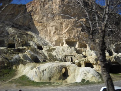
 In a striking landscape shaped by erosion, the Göreme Valley and its surroundings are home to rock sanctuaries, irreplaceable evidence of Byzantine art from the post-iconoclastic period, as well as dwellings, troglodyte villages and underground cities, vestiges a traditional human habitat whose beginnings date back to the fourth century.
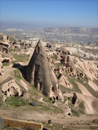
Located on the central plateau of Anatolia, in a volcanic landscape carved by erosion that has formed a succession of mountain ridges, valleys and peaks known as "fairy chimneys" or hoodoos, the Göreme National Park and the rocky sites of Cappadocia extend over a region that covers the cities of Nevsehir, Ürgüp and Avanos, the Karain, Karlik, Yesilöz, Soganli and the underground cities of Kaymakli and Derinkuyu.
The area is bordered on its southern flanks and is by chains of extinct volcanoes, with the Erciyes Dag (3916 meters) on one side and the Hasan Dag (3253 m) on the other. The density of its cells, churches, troglodyte villages and underground cities dug in the heart of the rock makes it one of the largest and most striking rock ensembles in the world.
Fascinating from a geological and ethnological point of view, the incomparable beauty of the setting of the Christian sanctuaries also makes Cappadocia one of the best examples of the Byzantine art of the post-iconoclastic period.
Sources : The National Parc
 Dans un paysage saisissant modelé par l'érosion, la vallée de Göreme et ses environs abritent des sanctuaires rupestres, témoignages irremplaçables sur l'art byzantin de la période post-iconoclaste, ainsi que des habitations, des villages troglodytiques et des villes souterraines, vestiges d'un habitat humain traditionnel dont les débuts remontent au IVe siècle.
Situés sur le plateau central d’Anatolie, dans un paysage volcanique sculpté par l’érosion qui a formé une succession de crêtes montagneuses, de vallées et de pics connus sous le nom de « cheminées de fées » ou hoodoos, le parc national de Göreme et les sites rupestres de Cappadoce s’étendent sur une région qui couvre les villes de Nevsehir, Ürgüp et Avanos, les sites de Karain, Karlik, Yesilöz, Soganli ainsi que les cités souterraines de Kaymakli et de Derinkuyu.
La zone est bordée sur ses flancs sud et est par des chaines de volcans éteints, avec l’Erciyes Dag (3916 mètres) d’un côté et le Hasan Dag (3253 m) de l’autre. La densité de ses cellules, églises, villages troglodytiques et cités souterraines creusés au cœur de la roche en fait l’un des plus grands et des plus saisissants ensembles rupestres au monde.
Fascinante d’un point de vue géologique et ethnologique, l’incomparable beauté du décor des sanctuaires chrétiens fait aussi de la Cappadoce un des meilleurs exemples de l’art byzantin de la période post-iconoclaste.
Sources : Le Parc National
 erozyon tarafindan heykel bir manzara, Göreme vadisi ve çevresi essiz sonrasi ikonoklastik süresi ve konutlarin Bizans teknikte kanit, ilkel insan köy ve yer alti sehirler saglayan kaya oyma yerleri, kalintilari içeren Baslangiçlari dördüncü yüzyila dayanan geleneksel bir insan habitati.
Volkanik bir dag sirtlari, vadileri ve "peri bacalari" olarak bilinen piklerin bir arkaya olusturmustur erozyon tarafindan heykel yatay veya hoodoos, Göreme Milli Parki içinde, Anadolu'nun orta platosunda bulunan ve Kapadokya'nin kaya Siteler Nevsehir, Ürgüp ve Avanos Karain siteleri, Karlik, Yesilöz, Soganli ve Kaymakli ve Derinkuyu yeralti sehirleri sehirleri kapsayan bir bölge üzerinde uzanir.
alan bir tarafta Erciyes daginin (3916 metre), diger yandan Hasan Dagi'na (3253 m) ile, sönmüs volkanlar zincirlerle güney ve dogu yönlerinde sinirlanmistir. Kayanin kalbi dünyanin en büyük ve en çarpici kaya sanati sitelerinden biri yapar onun hücreleri, kiliseler, ilkel insan köylerde ve yeralti sehirlerinin yogunlugu kazdik.
görünümünde bir jeolojik ve etnolojik açidan Büyüleyici, dekor Hiristiyan mabetler essiz güzelligi de Kapadokya sonrasi vadinin önemli Bizans sanatinin en iyi örneklerinden birini yapti.
Sources : Milli Park