Bearcreek Bank - Bearcreek, MT
Posted by: Groundspeak Premium Member T0SHEA
N 45° 09.657 W 109° 09.515
12T E 644724 N 5002480
The third smallest incorporated city in the State of Montana, one wouldn't expect Bearcreek to have had a great many banks - and it didn't.
Waymark Code: WMWW0K
Location: Montana, United States
Date Posted: 10/19/2017
Published By:Groundspeak Premium Member Outspoken1
Views: 0

Constructed in 1906, the one time Bearcreek Bank is one of the very few structures which remain in the hamlet, which for most of the first half of the twentieth century depended on the nearby Smith Creek Coal Mine for its livelihood. That all came crashing to an end with the Smith Mine disaster of 1943, a huge underground explosion which took the lives of 74 mine workers and one rescue worker. The disaster spelled the end for the mine, which never reopened, and essentially the end for Bearcreek.

Even before the explosion the town had been mostly dismantled and many of its buildings hauled to Bridger, Belfry and Red Lodge. The fortunes of coal mining in Montana had, since the end of World War I been on the downswing, except for those of larger strip mines in eastern Montana. If the 1943 explosion had not occurred, the days of the mine, then the last of four large mines in the Bearcreek area, were probably limited in any event. Most of those who still resided in Bearcreek by 1943 left for greener pastures, leaving just a handful of people and buildings.

The bank itself had long since failed, this occurring when the International Coal Company defaulted on a $170,000 loan in 1921. Opened as the Bearcreek Bank, it operated under that name until June 27, 1911 when the name was changed to the Clark - Wright Bank in Bearcreek. It continued in operation under that name until its failure in 1921. It was reopened in 1922 by former mine foreman Tom Frasure as the Miner’s State Bank, lasting until 1928, at which time it closed permanently. For some years after, the building housed a restaurant then, in 1967, was renovated to become the town hall for the little community of Bearcreek, which it remains today.

The village today, though far from thriving, refuses to die.
Bearcreek Bank The Bearcreek Bank is located at the northwest corner of Main Street (Montana Secondary 308) and Second Street in the City of Bearcreek. Main Street is an east-west trending thoroughfare that runs the length of Bearcreek parallel to the creek. Much of the community's historic business district has been demolished or relocated to Bridger, Belfry and Red Lodge in the aftermath of the Smith Mine Disaster in 1943.

The Bearcreek Bank consists of a one-story Romanesque Revival-style building. It is oriented north to south and faces south onto Main Street (Montana Secondary 308). The building has a shed roof flanked by parapet walls; the roof is sheathed in asphalt sheets with galvanized steel flashing. There is an interior brick chimney to the east that is veneered in stucco. The fa9ade (south) and east elevations of the bank are composed of rough-faced sandstone blocks set in a regular course. The top of the cornice and a belt course composed of sandstone is extended on the facade and east elevation. The building rests on a concrete foundation. There is a partial daylight basement with windows on the east. The windows are single-lite casements with iron grates and a low brick window well enclosure.

James "Yankee Jim" George discovered extensive coal deposits in the Bearcreek area in 1866. Its remoteness, lack of a market for the product, and its location within the Crow Reservation, delayed its exploitation for over two decades. By late 1887... ...the Northern Pacific Railway (NPRR) constructed a branch line from Laurel, Montana 44-miles south to Red Lodge and the coal mines. Completed in April 1889, the Rocky Fork & Cooke City Railway sparked an expansion of coal mining in the region, especially after the line was acquired by the NPRR the following year.

By the mid-1890s, many entrepreneurs recognized that the coal in the Bear Creek district was of much higher quality than that mined a few miles away in Red Lodge. Consequently, Billings surveyor George T. Lamport and former NPRR executive Elijah Smith established the first commercial mine in the district in 1897... ...In 1905, Billings bankers Christian and Peter Yegen, Bert E. Vaill, and Lamport formed the Bear Creek Coal Company and began operations a mile to the east of the Lamport/Smith Mine. Still, mining in the district was hampered by the lack of good roads and a railroad... ...In 1905, Billings entrepreneur Phil Gallaher was able to convince a group of Pennsylvania businessmen to finance the construction of a short line railroad from NPRR terminus at Bridger to the coal mines on Bear Creek. In May 1905, they incorporated the Yellowstone Park Railroad... ...Construction of the line began in September 1905 and was completed to the Bear Creek Coal Company Mine in September 1906.

The Picket reported in August 1906:

The future of the little city of Bearcreek may not be written until some other day. Its location is not the most desirable, topographically speaking, for a city of extensive magnitude. That it is destined to become one of the greatest coal mining camps in the entire western country, is an assured fact, and those who are acquainted with the lay of the country say that further down the valley, a short distance, may be found a location for a fine residence district. At present the town is growing rapidly, no less than ten buildings being in [the] course of construction. Among these are a building that is being erected by B. E. Vaill in which a bank will be established, a business building adjoining it... three other businesses and a number of dwelling houses.

In late June 1906, Bert Vaill, the cashier of the Carbon County Bank in Red Lodge, announced plans to build a branch institution in Bearcreek. Butte copper king and financier William A. Clark opened the Carbon County Bank in Red Lodge in the late 1890s. Vaill, who was also the Treasurer and a director of the Bear Creek Coal Company and heavily invested in the Yellowstone Park Railway, was the cashier for the bank. Vaill purchased Lot One, Block Three of the Original Townsite of Bearcreek from the Bearcreek Town & Improvement Company in February 1906 for $800. Six months later, in August, the Red Lodge Picket announced that Vaill began "hauling rock for his bank building next to the LeBrun Hotel".

By 1910, Bearcreek claimed a population of 302 people. The mines employed about half the adult male population of the community. The commercial district had expanded to include 23 businesses, including ten saloons.

The coal industry in south central Montana waned after World War I, initiating a boom and mostly bust cycle in the Bear Creek fields. The MW&S remained dependent on the NPRR, which often withheld coal cars from the mines. The precarious economic condition was exacerbated by the NPRR's increasing reliance on coal strip mined at Colstrip and by the increasing popularity of alternate fuels used for domestic purposes. Bearcreek's commercial district remained intact during the 1920s, but hard economic times during the 1930s caused a profound change in the city's appearance. In 1935, the Bearcreek High School's newspaper reported "Such a thing as passing a house on the road is not unusual to anyone around here. At the rate the houses are being moved, we may need a traffic cop to 'let the houses go by!'" Others burned down their buildings for the insurance money. Many just quit paying taxes on their property, which was then seized by the County. The old bank building, however, was used as a restaurant until 1943. The Smith Mine Disaster on February 27th of that year was the final straw for Bearcreek's already shaky fortunes.
From the NRHP Registration Form
BEARCREEK BANK

A coal-mining town established in 1905, Bearcreek developed quickly, and after just one year the town boasted telephones, city water, and electric streetlights. Bert Vaill, a cashier with the Carbon County Bank of Red Lodge, purchased this lot from the townsite company for $800, and in 1906 he hired John Russell to construct a one-story Romanesque style bank from native sandstone quarried just north of town. Symbolizing Vaill’s faith in Bearcreek’s future, the bank’s thick stone walls were also meant to assure customers that their money was safe from theft and bank failure, a tenuous assumption in the days before Federal Deposit Insurance. Part of a vibrant commercial district, the bank—owned for a time by Butte copper magnate William A. Clark—played a significant role in Bearcreek’s development through loans and investments. It also provided currency exchange for the community’s immigrant miners. When the International Coal Company defaulted on a $170,000 loan in 1921, the bank went into receivership. Former mine foreman Tom Frasure purchased the property and reopened the bank under the name Miner’s State Bank in 1922. In 1928 it, too, closed. The building then housed a restaurant until 1943. That year an explosion at the Smith Mine killed 74 miners. The disaster started an exodus from Bearcreek, causing the restaurant and many other businesses to close. Used for storage, the building was rehabilitated in 1967 for use as the Bearcreek City Hall, a function it has served ever since.     
From the NRHP plaque at the building
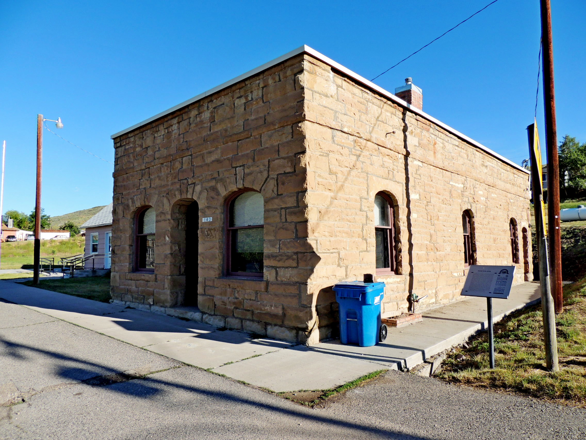
Street address:
143 Main Street
Bearcreek, MT United States
59007


County / Borough / Parish: Carbon County

Year listed: 2004

Historic (Areas of) Significance: Commerce, Politics/Government

Periods of significance: 1925-1949, 1900-1924

Historic function: Commerce/Trade - Financial Institution

Current function: Government - City Hall

Privately owned?: no

Primary Web Site: [Web Link]

Secondary Website 1: [Web Link]

Season start / Season finish: Not listed

Hours of operation: Not listed

Secondary Website 2: Not listed

National Historic Landmark Link: Not listed

Visit Instructions:
Please give the date and brief account of your visit. Include any additional observations or information that you may have, particularly about the current condition of the site. Additional photos are highly encouraged, but not mandatory.
Search for...
Geocaching.com Google Map
Google Maps
MapQuest
Bing Maps
Nearest Waymarks
Nearest U.S. National Register of Historic Places
Nearest Geocaches
Create a scavenger hunt using this waymark as the center point
Recent Visits/Logs:
There are no logs for this waymark yet.