|
 The Little Rocky Mountains II - Zortman, MT Posted by:  T0SHEA T0SHEA
N 47° 47.743 W 108° 38.009
12T E 677222 N 5296307
Along Highway 191 in north central Montana, at the junction with Highway 66 are a pair of Montana Historical Highway Markers, each describing a different aspect of the Little Rocky Mountains.
Waymark Code: WMWB5E
Location: Montana, United States
Date Posted: 08/06/2017
Views: 1
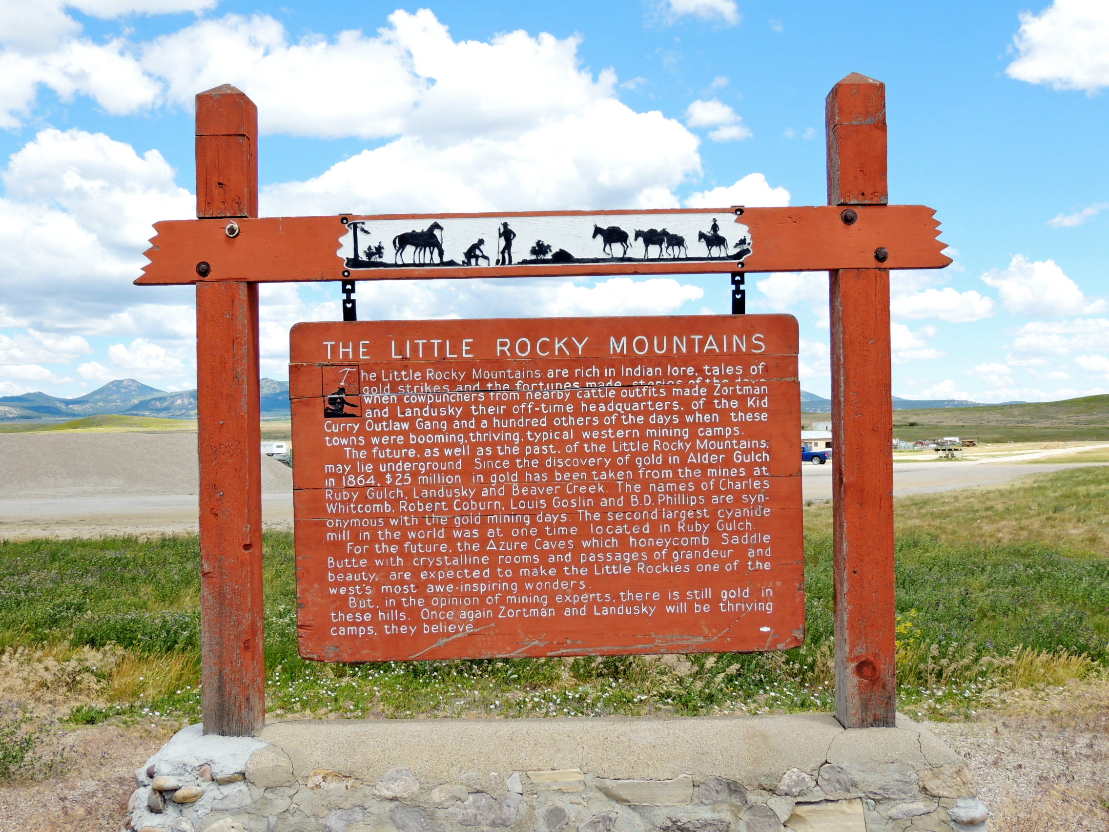
THE LITTLE ROCKY MOUNTAINS
The Little Rocky Mountains are rich in Indian Lore, tales of gold strikes and the fortunes made - stories of the days when cowpunchers from nearby cattle outfits made Zortrnan and Landusky their off-time headquarters, of the Kid Curry Outlaw Gang and a hundred others of the days when these towns were booming, thriving, typical western mining camps.
The future, as well as the past, of the Little Rocky Mountains, may be underground Since the discovery of gold in Alder Gulch in 1864. $25 million in gold has been taken from the mines at Ruby Gulch, Landusky and Beaver Creek. The names of Charles Whitcomb, Robert Coburn, Louis Goslin and B.D. Phillips are synonymous with the gold mining days. The second largest cyanide mill in the world was at one time located in Ruby Gulch.
For the future, the Azure Caves which honeycomb Saddle Butte with crystalline rooms and passages of grandeur and beauty, are expected to make the Little Rockies one of the west's most awe-inspiring wonders.
But, in the opinion of mining experts, there is still gold in these hills. Once again Zortrnan and Landusky will be thriving camps, they believe.
From the Montana Historical Highway Marker
The History of the Montana Historical
Highway Markers
[It was a man named Bob Fletcher whose idea it was, in 1935, to produce roadside signs which imparted knowledge of Montana's history, each sign containing a bit of the story of some local event or site.] The rustic-looking sign boards were mounted on lodgepole pine posts and hung from decorative routed crossbeams. The posts were set in fieldstone bases to make them eye-catching, rustic—and crash resistant. The sign texts were hand-lettered on five-by-eight-foot plywood boards set in log frames. The first marker, "Gates of the Mountains," was installed on U.S. Highway 91, about sixteen miles north of Helena, in early July 1935. It was followed by twenty-nine more signs by the end of the year.
Bob Fletcher's success in promoting and developing the tourist industry in the early 1930s enabled him to pitch a project that he'd been considering since the 1920s: roadside highway markers that described and celebrated Montana's colorful history. This idea allegedly originated after he became bored reading the historical markers installed by the Daughters of the American Revolution along South Dakota's roads in the mid 1920s. He felt he could do better in Montana by making the marker texts big enough to read from a car "and sometimes humorous." Fletcher later recalled that the texts "should not be a lot of stilted copy with dates and all. I wanted them to be like a native standing there and telling you about the place."
By the early 1950s, severe weathering of the signs compelled the department to begin routing the texts onto redwood boards. By 1952, the highway department had installed over one hundred markers along Montana's highways. Although Montana's historical highway marker program was not the first of its kind in the United States, it proved among the most influential. According to one newspaper article, twelve other state highway departments requested copies of the marker plans.
By the early 1980s, the interstates had diverted much of the traffic off the two-lane highways and onto the four-lane superhighways. Although some signs had been reinstalled at interstate rest areas, most had simply been forgotten, vandalized, stored in maintenance shops, or allowed to deteriorate next to bypassed highways. In 1985, the Forty-Ninth State Legislature allocated $200,000 to refurbish the 132 old markers (the original markers cost $400 each—including the support posts and field-stone bases!) and write twenty-four new ones.
Since 1985, over one hundred new historical markers have been added, covering a wide variety of subjects and styles. The markers have been printed on sturdy, weather-resistant plastic since 1999.
From the book Montana's Historical Highway Markers by the Montana Historical Society
Describe the area and history:
As one drives north on Highway 191 from the Missouri River, the Little Rocky Mountains slowly grow above the horizon to the northeast. Though miniscule compared to the "other" Rocky Mountains, they are sufficiently large to be seen from 20, possibly 30 miles distant.
This marker relates a bit of the story of the riches found in the Little Rockies, and those yet to be found.

|
Visit Instructions:
Please describe your visit- The good, the bad & the ugly. :)
Recent Visits/Logs:
| There are no logs for this waymark yet. |
|
|
|
|