|
 The Smith Mine Disaster - Bearcreek, MT Posted by:  T0SHEA T0SHEA
N 45° 09.511 W 109° 11.341
12T E 642338 N 5002155
Along Highway 308 about 1.5 miles west of the little hamlet of Bearcreek is the Smith Mine, the site of the worst coal mine disaster in Montana history. In sight of the remaining buildings at the mine site is this Montana Historical Highway Marker.
Waymark Code: WMWAN1
Location: Montana, United States
Date Posted: 08/03/2017
Views: 5
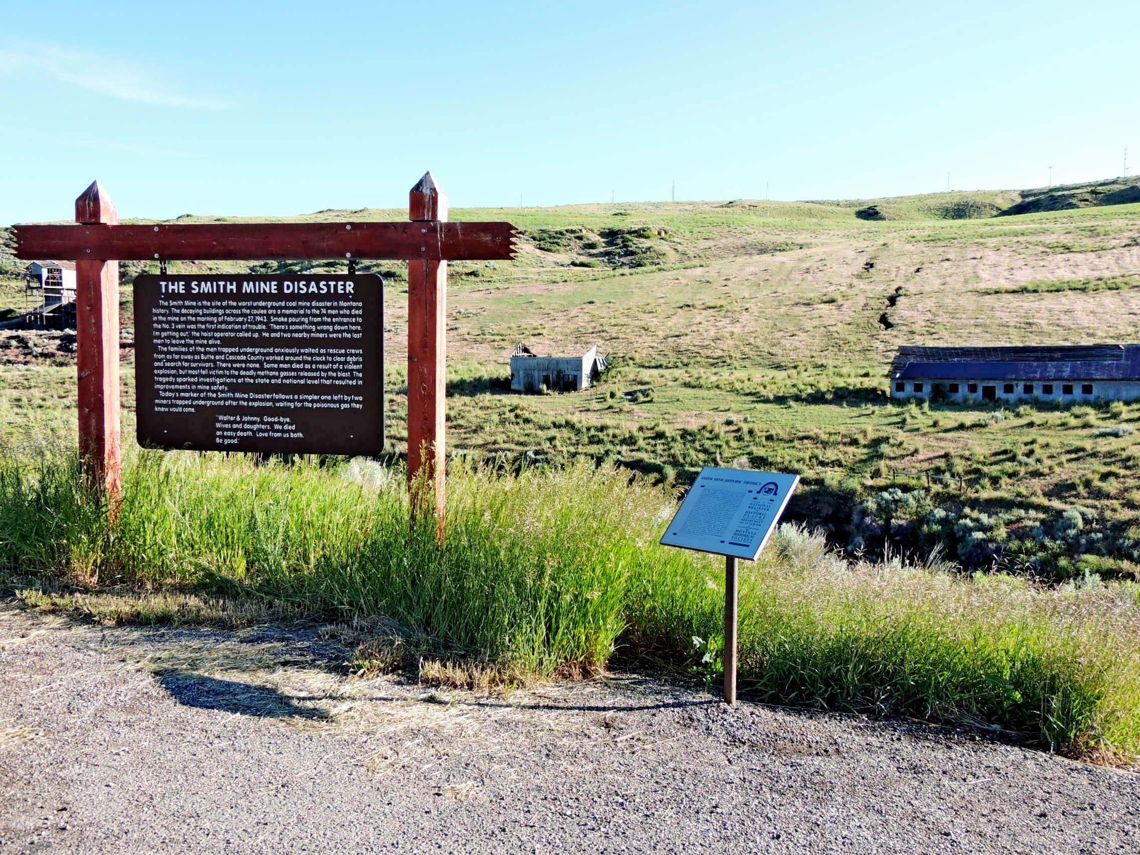
THE SMITH MINE DISASTER
The Smith Mine is the site of the worst underground coal mine disaster in Montana history. The decaying buildings across the coulee are a memorial to the 74 men who died in the mine on the morning of February 27, 1943. Smoke pouring from the entrance to the No. 3 vein was the first indication of trouble. "There's something wrong down here. I'm getting out", the hoist operator called up. He and two nearby miners were the last men to leave the mine alive. The families of the men trapped underground anxiously waited as rescue crews from as far away as Butte and Cascade County worked around the clock to clear debris and search for survivors. There were none. Some men died as a result of a violent explosion, but most fell victim to the deadly methane gasses released by the blast. The tragedy sparked investigations at the state and national level that resulted in improvements in mine safety. Today's marker of the Smith Mine Disaster follows a simpler one left by two miners trapped underground after the explosion, waiting for the poisonous gas they knew would come.
"Walter & Johnny. Good-bye.
Wives and daughters. We died
an easy death. Love from us both.
Be good."
From the Montana Historical Highway Marker
 The History of the Montana Historical Highway Markers
[It was a man named Bob Fletcher whose idea it was, in 1935, to produce roadside signs which imparted knowledge of Montana's history, each sign containing a bit of the story of some local event or site.] The rustic-looking sign boards were mounted on lodgepole pine posts and hung from decorative routed crossbeams. The posts were set in fieldstone bases to make them eye-catching, rustic—and crash resistant. The sign texts were hand-lettered on five-by-eight-foot plywood boards set in log frames. The first marker, "Gates of the Mountains," was installed on U.S. Highway 91, about sixteen miles north of Helena, in early July 1935. It was followed by twenty-nine more signs by the end of the year.
Bob Fletcher's success in promoting and developing the tourist industry in the early 1930s enabled him to pitch a project that he'd been considering since the 1920s: roadside highway markers that described and celebrated Montana's colorful history. This idea allegedly originated after he became bored reading the historical markers installed by the Daughters of the American Revolution along South Dakota's roads in the mid 1920s. He felt he could do better in Montana by making the marker texts big enough to read from a car "and sometimes humorous." Fletcher later recalled that the texts "should not be a lot of stilted copy with dates and all. I wanted them to be like a native standing there and telling you about the place."
By the early 1950s, severe weathering of the signs compelled the department to begin routing the texts onto redwood boards. By 1952, the highway department had installed over one hundred markers along Montana's highways. Although Montana's historical highway marker program was not the first of its kind in the United States, it proved among the most influential. According to one newspaper article, twelve other state highway departments requested copies of the marker plans.
By the early 1980s, the interstates had diverted much of the traffic off the two-lane highways and onto the four-lane superhighways. Although some signs had been reinstalled at interstate rest areas, most had simply been forgotten, vandalized, stored in maintenance shops, or allowed to deteriorate next to bypassed highways. In 1985, the Forty-Ninth State Legislature allocated $200,000 to refurbish the 132 old markers (the original markers cost $400 each—including the support posts and field-stone bases!) and write twenty-four new ones.
Since 1985, over one hundred new historical markers have been added, covering a wide variety of subjects and styles. The markers have been printed on sturdy, weather-resistant plastic since 1999.
From the book Montana's Historical Highway Markers by the Montana Historical Society
Describe the area and history:
Spread out along the valley in front of the pullout where the sign is mounted are the buildings of the Smith Mine. Some falling down, some fallen down and some which will stand for years, they represent the mine much as it was on the final day on which it operated, February 27, 1943, the day 75 men died below ground. 74 of the dead were mine workers, while one was a rescue worker

|
Visit Instructions:
Please describe your visit- The good, the bad & the ugly. :)
Recent Visits/Logs:
| There are no logs for this waymark yet. |
|
|
|
|