[EN] You will find these two hourglasses on the map explaining the different points of view you will encounter along this path.
They indicate the times of the different routes and the general route of the hiking trail.
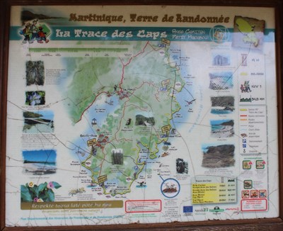
La Trace des Caps is one of the most famous hiking trails in Martinique, but it is also the longest.
This itinerary, mostly by the sea, allows you to discover the southern Atlantic coast with its barrier reef and its beautiful white sandy beaches.
Due to its length this hike can be done in several distinct stages.
It is thus usual to break it down into 5 sections: Petit Macabou - Cap Macré (5 km, 2 hours), Cap Macré - Cap Chevalier (7 km, 3 hours), Cap Chevalier - Baie des Anglais (6 km, 2h30), Anse Trabaud - Salines (5 km, 2 hours), Salines - Anse Caritan (4,5 km, 1h30).
The trek begins at the Anse du Petit Macabou, which you go along in the woods before joining the Grand Macabou.
[FR] Vous trouverez ces deux sabliers sur la carte expliquant les différents points de vue que vous rencontrerez tout au long de ce chemin.
Ils indiquent les temps des différents parcours et du parcours général du sentier de randonnée.
La Trace des Caps compte parmi les randonnées pédestres les plus réputées de Martinique mais c'est également, avec ses 27 kilomètres, la plus longue.
Cet itinéraire, qui reste le plus souvent en bord de mer, permet de découvrir le sud de la côte atlantique avec sa barrière de corail et ses magnifiques plages de sable blanc.
Compte tenu de sa longueur cette randonnée peut se faire en plusieurs étapes distinctes.
Il est ainsi habituel de la décomposer en 5 tronçons: Petit Macabou - Cap Macré (5 km, 2h), Cap Macré - Cap Chevalier (7 km, 3h), Cap Chevalier - Baie des Anglais (6 km, 2h30), Anse Trabaud - Salines (5 km, 2h), Salines - Anse Caritan (4,5 km, 1h30).
La randonnée débute donc à l'Anse du Petit Macabou que l'on longe en sous bois avant de rejoindre celle du Grand Macabou.
Sources : La Trace des Caps