
Bradfield Park - Uncovering the Past, Milsons Point, NSW
S 33° 50.722 E 151° 12.684
56H E 334517 N 6253550
This sign "Layers of History: Uncovering the Past" of Bradfield Park [North], outlines the archaeological work of 2003 and what was found.
Waymark Code: WMV9FD
Location: New South Wales, Australia
Date Posted: 03/18/2017
Views: 3
This sign, right by the footpath leading to Luna Park, Sydney Harbour, and Milsons Point train station, has a map of the archaeological excavation 'dig', by HLA Envirosciences.
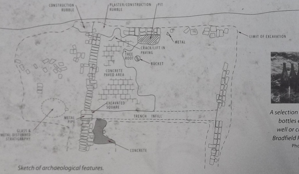
Sketch of Archaeological Features: by HLA Envirosciences
The text reads:
"During the 2003 upgrade of Bradfield Park North, workers found remnants of the buildings that had occupied the site before work on the bridge began.
"Several items of interest were discovered by archaeologists. Close to Alfred St South two parallel lines of machine-made, semi-dry bricks were uncovered.
[Photo of a selection of green glass bottles]
"The bricks were marked with an 'Ives Oaks' stamp and are thought to have been the original footings of the building at the rear of 125-127 Alfred Street, which was a store and stable. A rough concrete slab area was also unearthed. This is thought to have been the floor of the original building. The footprints of these buildings are now marked on the surface of the park.
"At the southern end of the site, three sandstone walls were found. The walls ran diagonally across the park and appear to be part of the original boundary walls used to separate building allotments.
[Photo of the 2003 archaeological dig in progress]
"At the northern end of the park, cream machine-made bricks were uncovered; their positioning suggests they were part of the Grantham Motor Service workshop.
"A circular brick shaft was uncovered that appeared to be a cistern to hold fresh water. Many other smaller artifacts were also uncovered, including intact green glass bottles, nails and bolts, and pieces of crockery, bone, wood, stone, leather, terracotta and shell.
"These and other items found such as leather belt, playing marble, cricket ball, child's china doll and slate pencils reflect the daily life and leisure activities of the occupants of the Alfred Street terraces in the late 19th and early 20th century. these relics are now held in the Stanton Library, together with a copy of the archaeologist's report."
[North Sydney Council seal]