
Pennyrile Lake Dam- KY Division of Water
Posted by:  Airmapper
N 37° 04.388 W 087° 39.888
16S E 440905 N 4103191
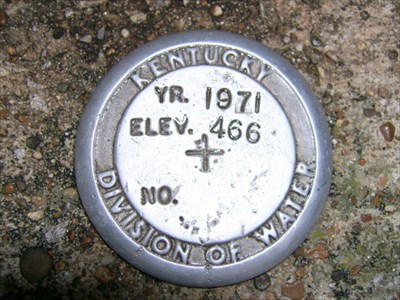
Kentucky Division of Water survey Mark
Waymark Code: WMV1H
Location: Kentucky, United States
Date Posted: 10/12/2006
Views: 54
This Benchmark is located inside Pennyrile State Resort Park.
From DAWSON SPRINGS, KY:
Start on SR-109 [S Main St
Turn RIGHT (South-West) onto SR-109 [Hamby Ave] for 0.2 mi
Turn LEFT (South-East) onto SR-109 [Hospital Dr] for 5.5 mi
Turn RIGHT (South-West) onto SR-398 for 0.5 mi
Turn RIGHT to stay on SR-398 for 0.7 mi
Turn LEFT to stay on SR-398 for 0.7 mi
Turn RIGHT (West) onto Local road(s) for 87 yds
Bear LEFT (West) onto Local road(s) for 0.7 mi
Turn LEFT (South) onto Local road(s) for 0.2 mi
Turn LEFT (East) onto Local road(s) for 65 yds
Arrive 37°4'23"N 87°39'53"W
Benchmark is located on the top of Pennyrile Dam, embedded into the concrete walkway crossing the top. Mark is located on the EAST side of the walkway, and can be reached by walking past the northern edge of the lodge, and behind the swimming pool. Head down rock steps to the walkway. Mark will be to your RIGHT.
Mark Year 1971
Elevation Stamped: 466