[FR] Surplombant la vallée de la Canche de 40 mètres, Montreuil-sur-Mer a hérité sa vocation de place forte grâce à cette position géographique privilégiée. Née d’un petit monastère, « Monasteriolum », devenu axes de circulation : une rivière, la Canche et une route terrestre.
Déjà fortifiée à la fin du 9ème siècle et rattachée au domaine royal en 987, Montreuil devient jusqu’en 1204 le seul port de mer des Capétiens. Afin de protéger cette ouverture maritime de premier plan, Philippe Auguste édifie au début du 13è siècle un puissant château royal et renforce l’enceinte urbaine.
Montreuil exporte alors ses draps dont la renommée rivalise jusqu’en Italie avec ceux de Flandre et d’Artois.
A la fin du Moyen Age, l’ensablement de la Canche et la Guerre de Cent ans entraînent le déclin de la ville. Pendant deux siècles, Montreuil ne joue qu’un rôle mineur avant de devenir un pion essentiel dans la défense du royaume face aux terres des Habsbourg.
En juin 1537, les troupes de Charles Quint et d’Henri VIII mettent la ville à sac. François 1er ordonne aussitôt la construction d’une enceinte urbaine complétée, trente ans plus tard, par une citadelle édifiée à l’emplacement du château médiéval.
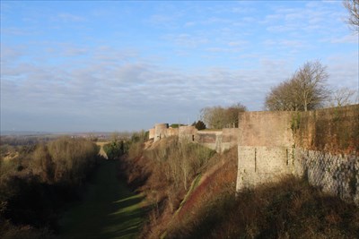
Selon la tradition, la première enceinte est construite au 9ème siècle par le Comte Helgaud II.
Renforcée au 13ème siècle, elle subit une diminution notable au 16ème siècle après la prise de la ville par les Impériaux en 1537.
On abandonne alors l’enceinte basse au sud-est. Errard de Bar Le Duc, Antoine de Ville et Vauban sont successivement chargés de la conforter.
A l’ouest du dispositif défensif de la ville, le front de la Madelaine se compose de 5 tours circulaires du 13ème siècle et du bastion de Bouillon.
Le front sud conserve 2 tours médiévales. A l’opposé, le front nord est percé d’une porte, la porte de Boulogne, reconstruite en 1828.
[EN] Overlooking the Canche Valley of 40 meters, Montreuil-sur-Mer has inherited its vocation of strong place thanks to this privileged geographical position. Born of a small monastery, "Monasteriolum", become axes of circulation: a river, the Canche and a land route.
Already fortified at the end of the 9th century and attached to the royal domain in 987, Montreuil became until 1204 the only sea port of the Capetians. To protect this prominent maritime opening, Philippe Auguste built a powerful royal castle at the beginning of the 13th century and strengthened the urban precinct.
Montreuil then exported his sheets whose fame rivals Italy with those of Flanders and Artois.
At the end of the Middle Ages, the silting up of the Canche and the Hundred Years War led to the decline of the city. For two centuries, Montreuil played only a minor role before becoming an essential pawn in the defense of the kingdom against the Habsburg lands.
In June 1537, the troops of Charles V and Henry VIII put the city to sack. Francois I immediately ordered the construction of an urban enclosure completed, thirty years later, by a citadel built on the site of the medieval castle.
According to tradition, the first enclosure was built in the 9th century by Count Helgaud II.
Reinforced in the 13th century, it underwent a notable decrease in the 16th century after the capture of the city by the Imperialists in 1537.
The lower enclosure is then abandoned to the south-east. Errard de Bar The Duke, Antoine de Ville and Vauban are successively responsible for strengthening it.
To the west of the defensive structure of the town, the front of the Madelaine consists of 5 circular towers of the 13th century and the bastion of Bouillon.
The southern front preserves 2 medieval towers. In contrast, the northern front is pierced by a door, the Porte de Boulogne, rebuilt in 1828.
Sources : Montreuil : les Remparts