|
 Latah Creek Bridge - Spokane, WA Posted by:  T0SHEA T0SHEA
N 47° 38.948 W 117° 26.974
11T E 466237 N 5277402
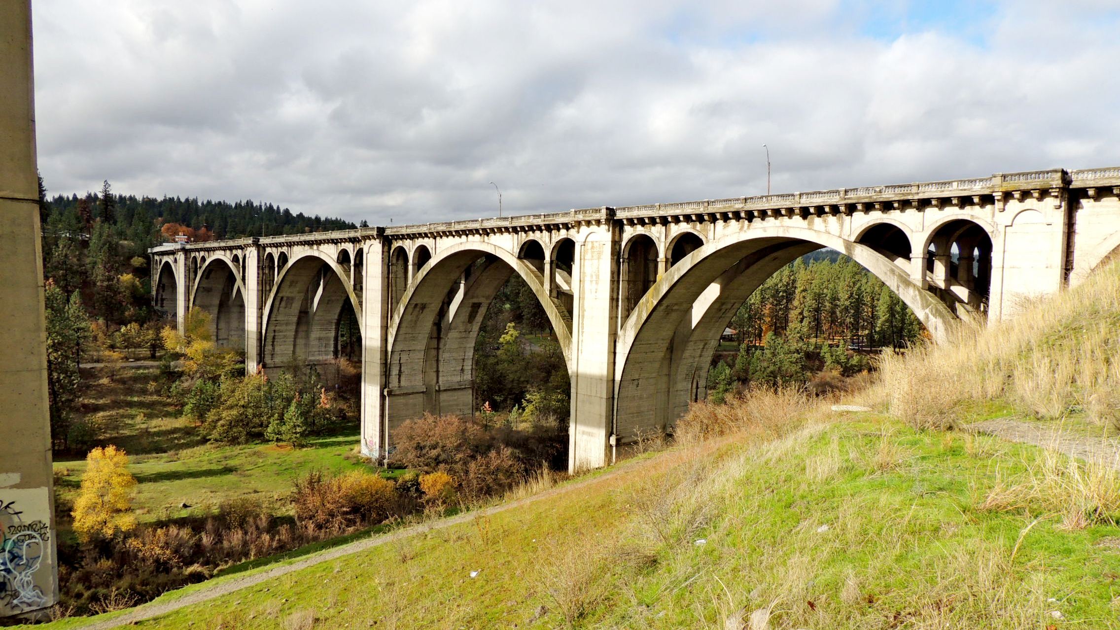
Today better known as the Latah Creek Bridge, the Sunset Boulevard Bridge was the second large concrete arch bridge to be built in the city of Spokane, with construction on the bridge beginning in 1911.
Waymark Code: WMTCQ1
Location: Washington, United States
Date Posted: 11/02/2016
Views: 1
The first, the Monroe Street Bridge, was of similar design and dimensions. 1070 feet in total length, the Latah Creek Bridge consists of two 150 foot arches, two 135 foot arches, one 128 foot arch, and two 54 foot approach arches. The bridge supports a 45 foot roadway with two 7 foot sidewalks edged with ornamental cast iron posts. When built, the bridge incorporated double tracks for the electric trolley cars which ran on the city's railway system.
The first bridge on the site, built in 1890, was of wood. It was replaced in 1905 and replaced again in 1911 by the present bridge, which opened for traffic in 1913. The $416,000 structure (quite a sum in 1911) was a joint project of the city and county of Spokane. Designed by W.S. Maloney, with consulting advice from Waddell and Harrington of Kansas City, the bridge was constructed by J.F. Cunningham of Spokane.
The Latah Creek Bridge, construction of which began in 1911, was Spokane’s second monumental concrete arch bridge. Composed of a series of Roman or semi-circular arches, the Latah Creek Bridge spans 1,070 feet with seven semi-circular arch spans 128 to 150 feet across. As is evident in the many similarities between this bridge and the Monroe Street Bridge, many of the people who were responsible for design and construction were involved in the development of both structures. Like the Monroe Street Bridge, the Latah Creek Bridge is an early example within the state of a long-span fixed-end arch. Although the semi-circular arches of the bridge were reminiscent of an earlier age of concrete and masonry arch construction, the steel reinforcement of the concrete structure pointed towards the future in concrete arch design.
From the Historic Spokane![]()
Length of bridge: 1070 feet

What type of traffic does this bridge support?: Vehicles, pedestrians
What kind of gap does this bridge cross?:
Creek valley
Date constructed: 1913
Is the bridge still in service for its original purpose?: Yes
Name of road or trail the bridge services: Sunset Boulevard
Location:
Spokane, WA
Height of bridge: Not listed
|
Visit Instructions:
Please submit a photo(s) taken by you of your visit to the location (non-copyrighted photos only). GPS photos are also accepted with the location in the background, and old vacation photos are accepted. If you are not able to provide a photo, then please describe your visit or give a story about the visit. If the bridge location prevents you from taking a safe photograph, then please do not stop to take the photo. Safety is more important.
Recent Visits/Logs:
| There are no logs for this waymark yet. |
|
|
|
|