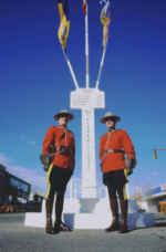
 Dawson Creek Historical Site
1879
 During a search for a suitable rail route through the Rockies, Dr. George Mercer Dawson Led a survey party through the valley.
1898 - 1914 Fur Traders, Prospectors, Police, Survey Parties and Settlers came on foot, by Ox Team, or horse drawn vehicles, over the old trails to this area.
1929 - 1931 The railroad pressed through to its present site and the town buildings were moved to what is now the city of Dawson Creek.
The Famous Mile "0" Post Stands 1/2 Block West and One Block North
DAWSON CREEK MILE "0" ALASKA (ALCAN) HIGHWAY
At this spot in the spring of 1942 at the height of World War 2 the US Army engineers began the construction of the overland route to Alaska. Nine months later at a cost of over $140,000.000 the road was completed. This is a road construction feat unsurpassed in modern times. 11,000 troops & 16,000 civilians were employed in this project.
There are 133 bridges & 8,000 culverts embodied in the 1523 miles of gravel highway. The rattle and roar of the mighty bulldozers was a source of amazement to both the local white man and the Northern Indian.
Over this lifeline to the northwest, thousands of troops, food & war supplies have been transported. In more recent times the mighty H Bomb was known to travel this route. It was maintained by the Canadian Army until April 1964. Maintenance was then taken over by the Dept. of Public Works, Ottawa.