Kön. Sächs. Triangulierung Station Wachau - Leipzig, Saxony, Germany
Posted by:  matefreund
N 51° 16.839 E 012° 26.870
33U E 322010 N 5684128
Es handelt sich um die Station 'Wachau' der Königlich Sächsischen Triangulierung von 1876.
This is the station 'Wachau' of the Royal Saxon Triangulation of 1876th.
Waymark Code: WMR6H2
Location: Sachsen, Germany
Date Posted: 05/17/2016
Views: 14
Die Königlich Sächsische Triangulierung ist eine von 1862 bis 1890 durchgeführte Landvermessung auf dem Gebiet des Königreiches Sachsen. Ziel war es, das Staatsgebiet wissenschaftlich-geodätisch exakt zu erfassen und mit der Festlegung dauerhaft vermarkter Festpunkte die Grundlage für die Herstellung genauer Kartenwerke zu schaffen.
Die Triangulation meint die Aufteilen einer Fläche in Dreiecke und deren Ausmessung. Sie ist das klassische Verfahren der Geodäsie zur Durchführung einer Landesvermessung.
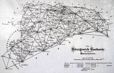
Das historische Königlich Sächsische Triangulierungsnetz umfasst 158 Stationen der ersten und zweiten Ordnung. Die Stationen der ersten Ordnung waren durchschnittlich 40km von einander entfernt und dienten der mitteleuropäischen Gradmessung. Die Stationen der zweiten Ordnung waren etwa 20 km von einander entfernt und dienten lediglich der sächsischen Triangulierung.
Die Station Wachau gehört zur zweiten Ordnung. Die Säule befindet sich direkt an der Bornar Straße kurz vor der Abzweigung Tollweg.

ENGLISH:
The Royal Saxon Triangulation is a 1862-1890 performed land surveying in the field of the Kingdom of Saxony. It was the aim, to capture the territory scientifically-geodetically precisely and to get a basis for the manufacture of accurate cartography.
Triangulation means the division of a surface into triangles and their gauging. It is the classic method of geodesy to pursue a state survey.
The historic Royal Saxon Triangulierung-Grid includes 158 stations of the first and second order. The stations of the first order have a distance of about 40 km from each other and serve the Central European arc measurement. The stations of the second order have a distance of about 20 km from each other and were only made for Saxon Triangulation.
The station Wachau is part of the second order. The column is located directly on the 'Bornar Straße'.
Quellen/Sources:
*(de.wikipedia.org about Königlich Sächsische Triangulierung)
*(de.wikipedia.org about Triangulierung (Geodäsie))