|
 Fort O'Brien - Machiasport, ME Posted by:  T0SHEA T0SHEA
N 44° 41.366 W 067° 23.736
19T E 627132 N 4949703
Fort Machias was built in 1775 on Machias Bay at the mouth of Machias River, shortly after the beginning of the American Revolutionary War.
Waymark Code: WMQ72E
Location: Maine, United States
Date Posted: 01/01/2016
Views: 1
The fort is one of a very few in Maine which were active in the American Revolution, the War of 1812 and the Civil War. Captured and burned by the British in 1814, the fort was returned in 1818. Rebuilt in 1863, the fort was renamed Fort O'Brien.
Originally a four gun battery, the fort was built at the mouth of Machias River to protect the town from the evil British, continuing in service throughout the war. During the War of 1812 it was again pressed into service, still as a four gun battery, captured and returned. Again, this time during the Civil War, the fort came into service, this time being rebuilt beside the ruins of the old fort, with a complement of five guns.
Today the site of the fort is a State of Maine Historic Site and a State Park.
More detail on the fort is to be found further below.
About two miles offshore from Fort Machias/O'Brien, near Round Island, is the site of what is locally claimed to be the First Naval Battle of the American Revolutionary War, the Battle of Machias, fought between citizens of Machias and a British warship, the Margaretta. Unfortunately, the Battle of Machias was actually the second naval battle of the war, the first taking place on May 14, 1775 at Fairhaven, Massachusetts, the Battle off Fairhaven, in which the Dartmouth whaling sloop Success captured a pair of vessels previousy captured by the British.
The Battle of Machias took place on June 11-12, 1775 with the British sloop tender Margaretta being captured by the townspeople at the cost of one man killed and six wounded, one of which later died of his wounds. Here is a recounting of the battle, taken from informational plaques at the fort.
Fort O’Brien Historical Park
Fort O’Brien Historical Park was built after the capture of the British ship, “Margareta”. Originally named Fort Machias, Fort O’Brien was upgraded by Massachusetts in 1777 and taken over by Congress in 1781. The Continental Congress took over control of the structure in 1781. Fort O’Brien suffered no further attacks during the Revolutionary War. It was next returned to active service during the War of 1812. In 1814, Fort O’Brien was captured by 900 British regulars, who removed the fort’s guns and burned the barracks. Fort O’Brien once again activated (for a final time) during the Civil War when an entirely new battery was constructed just south of the 18th century fortifications. Fort O’Brien, which is now a State Historic Site under the management of the Bureau of Parks and Lands, is also listed as an archaeological site. The Fort was attacked in 1814 by the British and abandoned. It was activated again in 1863 at the height of the Civil War and refortified. It is now called Fort O’Brien Historical Park and is a State Park on a prominent earthwork overlooking the Machias River.
From the Town of Machiasport Historic Fort Machias
Built in 1775 immediately after the first naval battle of the American Revolution took place offshore, Fort Machias was a four-gun battery that guarded the mouth of the Machias River in cooperation with Fort Foster, located a mile or so upriver. The British destroyed the fort in the same year. This state historic site is one of few Maine forts active during three wars - the American Revolution, War of 1812 and Civil War. The fort's layout was altered several times over the 90 years it was active on this site, but the fort's important role in protecting the Machias River and its towns remained unchanged. It was refortified in 1777.
From 1808 - 1818, this was a four-gun crescent-shaped earthwork fort. In 1814 the British captured the fort and burned the barracks. It was returned in 1818.
The Cannon
In the middle of the earthworks of the Civil War era battery is a bronze cannon known as a "Napoleon" or 12-pounder. It fired 12 pound cannonballs, spherical case shot, or cannister, the latter being made up of numerous small pieces of iron that tore through infantry formations or a ship's rigging at close range. This cannon tube weighs 1216 pounds and was made at the Ames Manufacturing Company of Chicopee, Massachusetts in 1862. It originally sat on a wooden carriage that weighed an additional 1128 pounds. In optimal conditions, this gun could fire a ball 1600 yards, just enough to reach across the mouth of the Machias River.
Fort O'Brien
Fort O'Brien (1863 - 1865) was a Civil War five-gun earthworks fort built next to the ruins of Fort Machias. Well-preserved earthworks which overlook Machias Bay were erected fora battery of guns in 1863. In 1923, the United States Government deeded the site of both forts to the State of Maine.
The Foster Rubicon
A bronze tablet, mounted on a stone on the east side of Route 92 between here and Machias, reads:
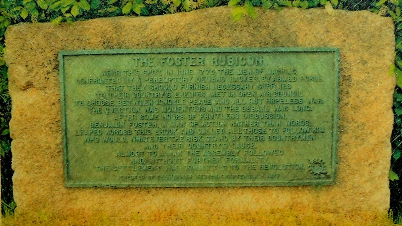
Near this spot, in June 1775, the men of Machias, confronted by a peremptory demand backed by armed force that they should furnish necessary supplies to their country's enemies, met in open air council to choose between ignoble peace and all but hopeless war. The question was momentous and the debate was long. After some hours of fruitless discussion, Benjamin Foster, a man of action rather than words, leaped across this brook and called all those to follow him who would, whatever the risk, stand by their countrymen and their country's cause. Almost to a man the assembly followed and, without further formality, the settlement was committed to the Revolution.
From informational plaques at the fort
![]()
Street address:
506 Port Road
Machiasport, ME USA
04655

County / Borough / Parish: Washington
Year listed: 1969
Historic (Areas of) Significance: Military
Periods of significance: 1850-1874, 1825-1849, 1800-1824, 1750-1799
Historic function: Defense - Battle Site, Fortification, Naval Facility
Current function: Recreation And Culture
Privately owned?: no
Hours of operation: From: 9:00 AM To: 8:00 PM
Primary Web Site: [Web Link]
Secondary Website 1: [Web Link]
Secondary Website 2: [Web Link]
Season start / Season finish: Not listed
National Historic Landmark Link: Not listed
|
Visit Instructions:
Please give the date and brief account of your visit. Include any additional observations or information that you may have, particularly about the current condition of the site. Additional photos are highly encouraged, but not mandatory.
Recent Visits/Logs:
| There are no logs for this waymark yet. |
|
|
|
|