|
 Barragem de Lucefécit - [Alandroal, Évora, Portugal]
N 38° 38.130 W 007° 24.380
29S E 638707 N 4277533
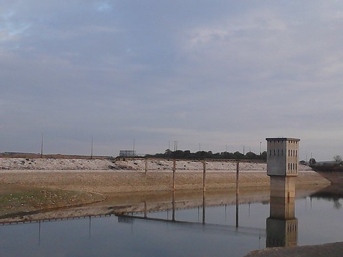
A barragem de Lucefécit localiza-se no concelho de Alandroal, distrito de Évora, Portugal. Situa-se na ribeira de Lucefécit. A barragem foi projectada em 1976 e entrou em funcionamento em 1982.
Waymark Code: WMQ62G
Location: Évora, Portugal
Date Posted: 12/27/2015
Views: 1
| Barragem de Lucefécit - [Alandroal, Évora, Portugal] |  É uma barragem de aterro. Possui uma altura de 27 m acima da fundação (23 m acima do terreno natural) e um comprimento de coroamento de 285 m (largura 8 m). O volume da barragem é de 300.000 m³. Possui uma capacidade de descarga máxima de 15 (descarga de fundo) + 390 (descarregador de cheias) m³/s.
A albufeira da barragem apresenta uma superfície inundável ao NPA (Nível Pleno de Armazenamento) de 1,68 (1,69) km² e tem uma capacidade total de 10 (10,225) Mio. m³; a capacidade útil é de 8,75 (9) Mio. m³. As cotas de água na albufeira são: NPA de 182 metros, NMC (Nível Máximo de Cheia) de 183,5 metros e NME (Nível Mínimo de Exploração) de 172,5 metros.
|  It is an embankment dam . It has a height of 27 m above the foundation (23 m above natural ground ) and a crown length of 285 m (width 8 m) . The dam volume is 300,000 cubic meters . It has a maximum discharge capacity of 15 ( bottom discharge ) + 390 ( filled discharger ) m³ / s .
The dam reservoir has a floodplain to the NPA ( Full Storage Level ) 1.68 (1.69 ) km² and has a total capacity of 10 ( 10.225 ) Mio. m³ ; the useful capacity of 8.75 ( 9) Mio. m³ . Water quotas are on the Bayou : NPA of 182 meters, NMC (Level Maximum Full ) of 183.5 meters and NME ( Lowest operating level ) of 172.5 meters .
| 

Waterway where the dam is located: Lucefécit riverside

Main use of the Water Dam: Water Supply (Drinkable)
Material used in the structure: embankment
Height of Dam: 27 meters
Fishing Allowed: yes
Date built: Not listed
Motor Sports Allowed: Not Listed
|
Visit Instructions:
Photo of the Dam and a description of your visit.
Recent Visits/Logs:
| There are no logs for this waymark yet. |
|
|
|
|