The following information about Captain Clark's journey along the Yellowstone River is from
Frances Hunter's American Heroes Blog :
"During the return journey from the Pacific coast in 1806, Lewis and Clark decided to divide their party so that they could do some extra exploring. For more than a month — July 3 to August 12 — they were out of contact with each other. ...Meriwether Lewis had a huge adventure in which he almost got killed, twice. William Clark, on the other hand, had a time so idyllic that it is often overlooked even by historians of the Expedition. But it shouldn’t be, because during that month, in his own patented “no drama” fashion, Clark led the pioneering exploration of the Yellowstone River and southwest Montana.
The Yellowstone River is the principal tributary of the upper Missouri. It is actually bigger than the Missouri at the point where it joins the great river, flowing in from the south and draining the entire basin of present-day Yellowstone National Park and the high plains of southern Montana and northern Wyoming. It was called “yellow stone” by the Hidatsa Indians, probably for the color of the rocks in the Grand Canyon of the Yellowstone. Lewis and Clark translated the name into English (independently, French fur trappers also translated the Hidatsa into Roche Jaune or Yellow Rock). The river was best-known to western tribes such as the Lakota, Cree, Crow, and Cheyenne, who used it and its tributaries to get around their rich summer hunting grounds.
Lewis and Clark had passed the Yellowstone on their way west back in 1805, but they barely had time to do more than examine its confluence with the Missouri. This time, Clark would make a full reconnaissance. His party included York, Sacagawea and her family, and 13 men. For the first time in the journey, Sacagawea actually got to be a guide."
The display at the Billings Chamber of Commerce includes three panels titled: Clark's Voyage Home, Evidence of the Expedition, and Returning to the Plains (see below).
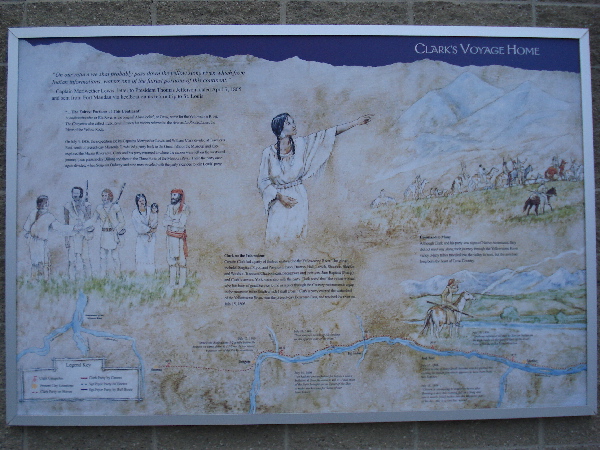
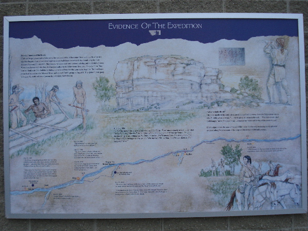
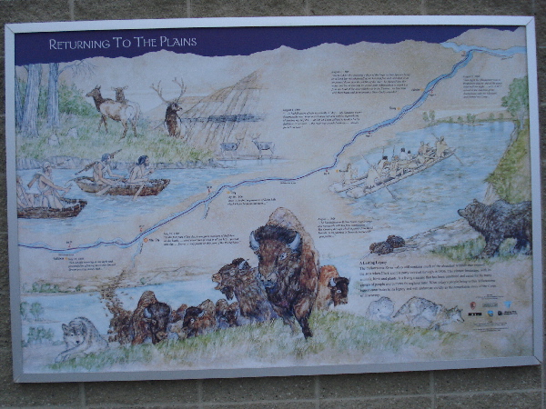
The timeline itself is laid out along the Yellowstone River on all three panels. Excerpts of Clark's journal entries are listed by date and are placed where the observations where made along the river:
July 15, 1806: "Struck the Rochejhone 1/2 a mile below the branch we came down & 1 1/2 ms. below where it passes out of the Rocky mountains."
July 16, 1806: "Saw emence heards of Elk feeding on the opposit side of the river."
July 16, 1806: "we had not proceeded on far before I saw a buffalo & Sent Shannon to kill it... I had most of the flesh brought on an a part of the Skin to make mockersons for Some of our lame horses."
July 17, 1806: "I Saw in one of those Small bottoms which I passed this evening an Indian fort which appears to have been built last Summer."
July 18, 1806: "Gibson in attempting to mount his horse after Shooting a deer this evening fell and on a Snag and sent it nearly two inches into the Muskeler part of his thy... this is a very bad wound."
July 19, 1906: "Shabono informed me that he Saw an Indian on the high lands on the opposit Side of the river. I saw a Smoke in the Same direction."
July 20, 1806: "The horses being fatigued and their feet very Sore, I Shall let them rest a fiew days. dureing which time the party... will dress their Skins and make themselves Clothes to bare, as they are nearly naked."
"I deturmined to have two Canoes made out of the largest of those trees and lash them together which will Cause them to be Study and fully Sufficient to take my Small party & Self with what little baggage we have down this river."
July 21, 1806: "This morning I was informed that Half of our horses were absent."
July 23, 1806: "Sgt. pryor found an Indian Mockerson and a Small piece of a roab... those Indian Signs is Conclusive with me that they have taken the 24 horses which we lost..."
July 24, 1806: "had all our baggage put on board of the two Small Canoes which when lashed together is very Study. ...at 8 A M. we Set out..."
July 25, 1806: "The nativs have ingraved on the face of this rock the figures of animals &c. near which I marked my name and the day of the month & year."
"I encamped on the Stard. Side imediately below the enteranc Shannons River about 22 Yards wide, and at this time discharges a great portion of water which is very Muddy."
July 27, 1806: "when we pass the Big horn I take my leave of the view of the tremendious chain of Rocky Mountains white with Snow."
July 28, 1806: "Set out this morning at day light and proceeded on glideing down this Smooth Stream passing maney Isld."
July 29, 1806: "in the fore part of the day, I saw great numbers of Buffalow on the banks. ...great quantities of Coal in all the hills I passed this day. ...Beaver is very plenty on this part of the Rochejhone."
July 30, 1806: "here is the first appearance of Birnt hills which I have Seen on this river..."
August 1, 1806: "...we had Showers of rain repeetedly all day... My Situation a very disagreeable one. in an open Canoe wet and without a possibility of keeping my Self dry. ...at 2 P.M. I was obliged to land to let the Buffalow Cross over. ...the river was crouded with those animals for 1/2 an hour."
August 2, 1806: "about 8 A. M this morning a Bear of the large vicious Species being on a Sand bar raised himself up on his hind feet and looked at us as we passed down near the middle of the river. he plunged into the water and Swam towards us, either from a disposition to attack't or from the Cent of the meat which was in the Canoes. we Shot him with three balls and he returned to Shore badly wounded."
August 3, 1806: "The Rochejhone or Yellow Stone river is large and navagable with but fiew obstructions... The Country through which it passes from those Mounts. to its junction is Generaly fertile rich open plains..."
August 3, 1806: "last night the Musquetors was so troublesom that no one of the party Slept half the night. ...at 8. A.M. I arived at the junction of the Rochejhone with the Missouri, and formed my Camp..."
For those interested, the full journal entries made by both Lewis and Clark are available online (visit link).
The timeline is located on the outside front wall of the Chamber of Commerce building and is available to see 24/7 daily. There is no fee to view the timeline.