|
 West Quoddy Head Light - Lubec, Maine Posted by:  T0SHEA T0SHEA
N 44° 48.894 W 066° 57.051
19T E 662023 N 4964431
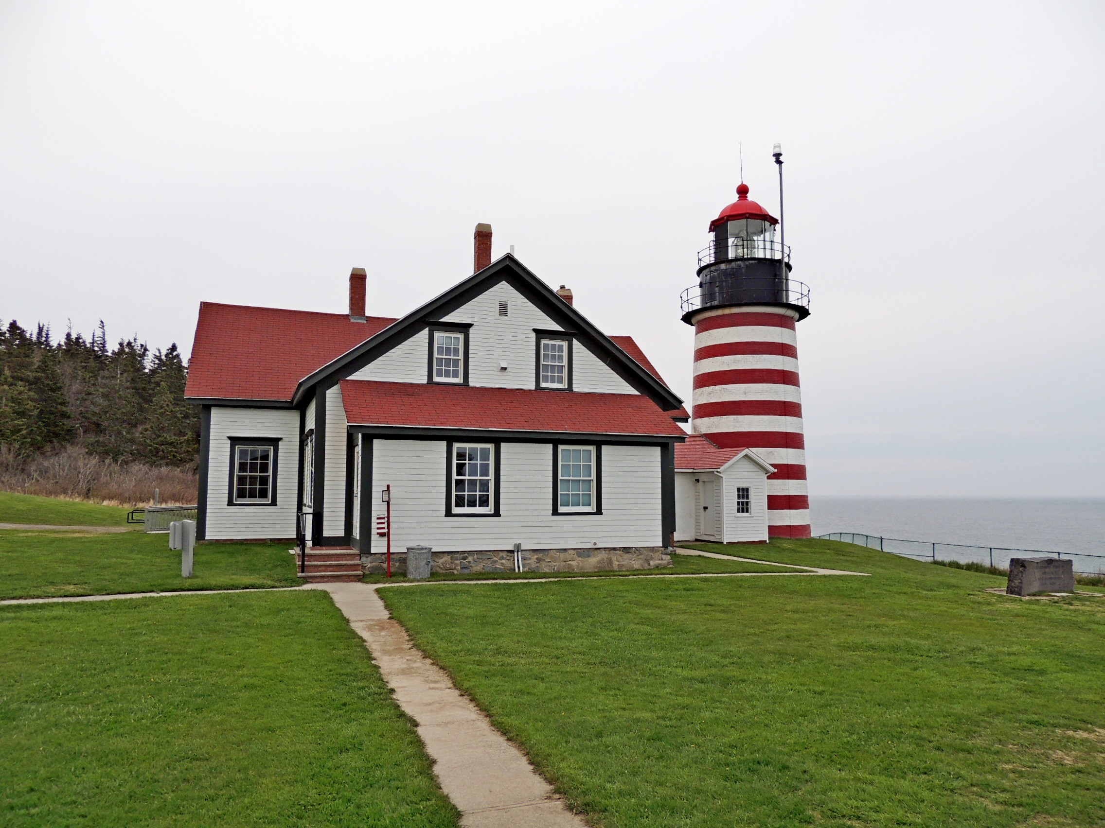
This red and white striped lighthouse has, for the most part, kept sailors off the Quoddy head rocks for 157 years, as of this year, 2015.
Waymark Code: WMNZ3G
Location: Maine, United States
Date Posted: 05/27/2015
Views: 3
The easternmost point in the US is Sail Rock, a few hundred feet off the eastern tip of Quoddy Head in Eastern Maine. Sail Rock is the third and last in a series of rocks off the shore. It has been a navigational hazard to shipping for as long as man has sailed these waters. As a result, a lighthouse, the Quoddy Head Lighthouse, stands on the coast nearby and a groaner buoy has been installed on the seaward side of the rock.
Two principal structures are present, the lighthouse and the keeper's quarters. The lighthouse consists of a circular tower 49 feet tall above the ground and narrower at the top than at the base. Above this the light proper, with an 18-mile maximum range, rises 83 feet above the water. At the top of the tower is an iron railing and slightly projecting walkway, and there is a similar feature at the level of the light. The most distinctive aspect of the lighthouse tower are the alternating red and white horizontal bands. A covered brick entry and attached frame entry are both covered by gabled roofs.
From the National Register
The lighthouse was built in 1858, on a site that has hosted a lighthouse since 1808. On July 4, 1980 the Quoddy Head Light was entered in the US National Register of Historic Places. Some information on the lighthouse and surrounding area, from nearby plaques, is included below.
Quoddy Head
A lighthouse beacon and fog signal have guided ships through the Quoddy Narrows between Campobello and West Quoddy Head since 1808. The present brick, red-and-white banded lighthouse was built in 1858. The beacon, 83 feet above sea level, can be seen from 20 miles at sea on a clear night. A radio beacon from the lighthouse serves as a navigational aid. A whistle or groaner buoy, located one mile offshore sounds a warning for Sail Rock.
West Quoddy Head Light looks over the islands of two nations. Campobello, The Wolves and Grand Manan lie in Canada. Sail Rock, which reportedly caused many shipwrecks off these shores, belongs to the United States.
Finback, minke, humpback and northern right whales migrate here each summer from their winter habitats off the southern coast of North America and the north-eastern coast of South America. They find these waters rich with food, such as herring, mackerel and microscopic plant and animal life. Studies show that northern right whales mate, and northern rights and finbacks calve in this part of the Bay of Fundy.
These whales can be recognized by the distinctive shapes of their dorsal fins and tails. When exhaling, whales also emit a characteristic "blow", which aids in identification.
The waters off West Quoddy Head peninsula form part of the open end of Canada's Bay of Fundy, which lies between New Brunswick and Nova Scotia.
The shape of the Bay of Fundy causes extremely high tides. At West Quoddy Head, tides rise and fall an average of 15.8 feet in six hours. The cool, nutrient-rich waters host abundant marine life in the large intertidal zone. Northern types of seaweed are found here, along with arctic clams and snails, anemones and sea stars.
Grand Manan Island, New Brunswick, lies about ten miles southeast of West Quoddy Head and, on clear days, can be seen from many points on the park's shoreline. Grand Manan is famous for spectacular rock cliffs along its west shore that rise 200 to 400 feet. The island was first settled by British Loyalists who fled the American Revolution. Today, as in the past, Grand Manan's population of about 2,300 lives on the island's east coast, where fishing for herring, cod and lobster is a way of life.
QUODDY HEAD STATE PARK
Quoddy Head State Park, located on the peninsula of West Quoddy Head, is the easternmost point in the United States. Steep rock cliffs, a peat bog and trees shaped by harsh winds characterize the park's environment. West Quoddy Head is wrapped in fog for an average of 59 days a year, and has some of Maine's coolest summer temperatures. Over time, these temperatures, a moist climate and the area's topography created conditions for the formation of a coastal peat bog — a park feature typical of maritime eastern Maine and New Brunswick.
The park's rock cliffs are remnants of marine volcanoes that erupted 420 million years ago and now form the bedrock of much of coastal Maine and New Brunswick. The horizontal volcanic layers were tilted almost to vertical along the Fundean fault — a fracture in the earth's crust that parallels the coast just off the park's shores. Glacial scouring and the battering surf have carved the cliffs, which rise 90 to 150 feet from the sea.
From the Plaques
 Visit Instructions:
To post a visit log to this waymark you need to visit and write about the actual physical location. Any pictures you take at the location would be great, as well.
|