Text of the marker is as follows:
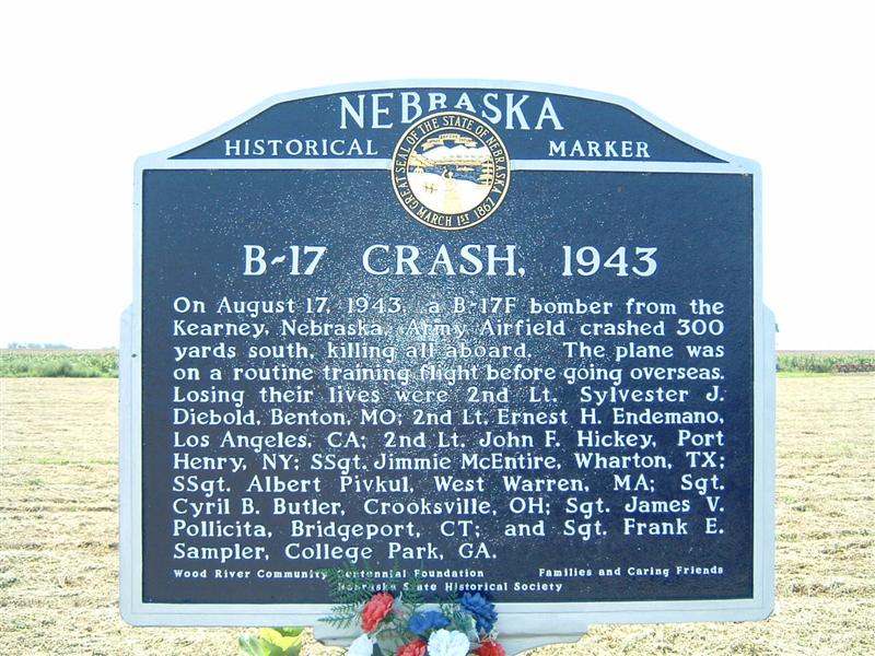 "On
August 17, 1943, a B-17F bomber from Kearney, Nebraska, Army Airfield crashed
300 yards south, killing all aboard. The plane was on a routine training flight
before going overseas. Losing their lives were 2nd Lt. Sylvester J. Diebold,
Benton, MO; 2nd Lt. Earnest H. Endemano, Los Angeles, CA; 2nd Lt. John F.
Hickey, Port Henry, NY; SSgt Jimmie McEntire, Wharton, TX; SSgt Albert Pivkul,
West Warren, MA; Sgt. Cyril B. Butler, Crooksville, OH; Sgt. James V. Pollicita,
Bridgeport, CT; and Sgt. Frank E. Sampler, College Park, GA."
"On
August 17, 1943, a B-17F bomber from Kearney, Nebraska, Army Airfield crashed
300 yards south, killing all aboard. The plane was on a routine training flight
before going overseas. Losing their lives were 2nd Lt. Sylvester J. Diebold,
Benton, MO; 2nd Lt. Earnest H. Endemano, Los Angeles, CA; 2nd Lt. John F.
Hickey, Port Henry, NY; SSgt Jimmie McEntire, Wharton, TX; SSgt Albert Pivkul,
West Warren, MA; Sgt. Cyril B. Butler, Crooksville, OH; Sgt. James V. Pollicita,
Bridgeport, CT; and Sgt. Frank E. Sampler, College Park, GA."
Wood River Community Centennial Foundation
Families and Caring Friends
Nebraska State Historical Society
Husker Highway and 150th Road, Wood River
Hall County
Marker 435