Moyie River Canyon Bridge - Boundary County, ID
Posted by: Groundspeak Premium Member T0SHEA
N 48° 43.631 W 116° 10.596
11U E 560553 N 5397455
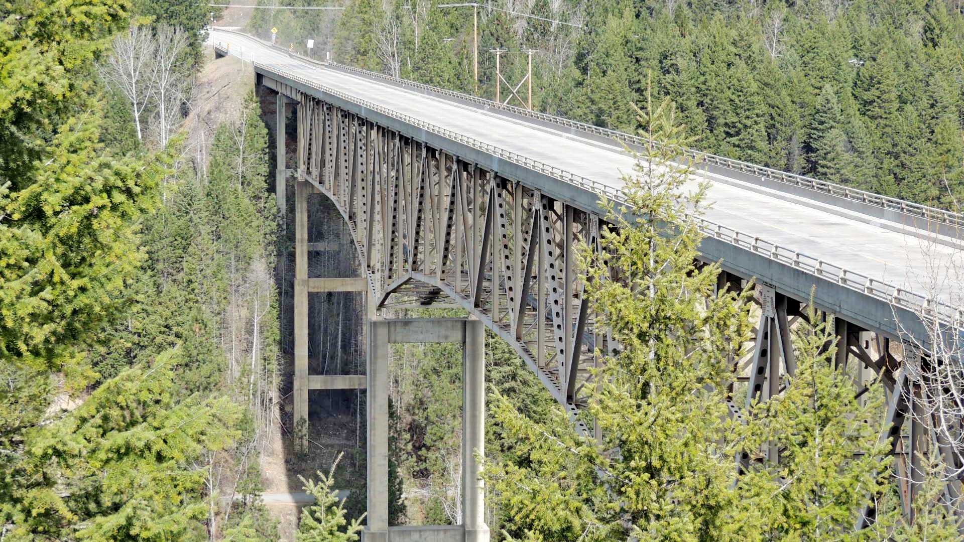
This is a tall and long bridge. Built in 1965, it is 464 feet tall and 1223 feet long. It carries Highway 2 over the Moyie River just east of the little town of Moyie.
Waymark Code: WMNFGV
Location: Idaho, United States
Date Posted: 03/05/2015
Published By:Groundspeak Premium Member Marine Biologist
Views: 1

Spanning the Moyie River Canyon and the Moyie River below, the steepness and depth of the canyon necessitated a rather large bridge. Such wasn't the case 92 years ago in 1923 when the first bridge on this spot was built. It was built across the bottom of the canyon and required an extra 1¼ miles of twisting and turning narrow highway down into the canyon and back up the other side.

This is a cantilever truss bridge standing on tall reinforced concrete piers in the canyon and has steel girder approach spans on each end.

Coordinates given are at the roadside pullout on the east end of the bridge which affords a great view of not only the bridge but the Moyie River Dam north up the river from the highway. Also, there are some informative informational signs on the bridge, the canyon, the river and the dam at the pullout.
MOYIE RIVER CANYON Constructed in 1964, the 1223 ft. long steel truss bridge spans the Moyie River Canyon at a height of 464 ft. It replaces the old bridge built in 1923 and I 1/4 miles of narrow, winding highway. It is the second highest bridge in Idaho, exceeded only by the 476 ft. high Perinne Memorial Bridge across the Snake River near Twin Falls.

The power dam, constructed by the City of in Bonner Ferry, supplies electricity to the surrounding area. The original dam built in 1921 was razed in 1949 on completion of the new dam. The spillway is 83 ft. high and the drop is 212 ft. from top of dam to lower pool. Niagara Falls has a drop of 168 ft.

The 100 mile long Moyle River has its headwaters in British Columbia and flows to the Pacific Ocean by way of the Kootenai and Colombia Rivers.

This Viewpoint and Rest Area is maintained by the Idaho Department of Highways
Transcribed from sign
Wikipedia Url: [Web Link]

Visit Instructions:
To post a visit log to this waymark you need to visit and write about the actual physical location. Any pictures you take at the location would be great, as well.
Search for...
Geocaching.com Google Map
Google Maps
MapQuest
Bing Maps
Nearest Waymarks
Nearest Wikipedia Entries
Nearest Geocaches
Create a scavenger hunt using this waymark as the center point
Recent Visits/Logs:
There are no logs for this waymark yet.