
Milwaukee Road Trail System - Missoula, MT
Posted by:  T0SHEA
N 46° 52.068 W 113° 59.901
12T E 271493 N 5194838
This rail trail is part of the Ron MacDonald Riverfront Trail System in Missoula, MT. An ongoing project, it grows with each passing year.
Waymark Code: WMNDEY
Location: Montana, United States
Date Posted: 02/20/2015
Views: 2
There are many trails that either make up or connect with this section of trail system, so it gets s little confusing as to which trail begins and ends where... so, following is the city's explanation of this bit of trail.
In the 1970s the Milwaukee grade was officially abandoned and properties were sold off. The City of Missoula has converted some of the old Milwaukee Road right-of-way into the main east-west spine of its non-motorized Bicycle Commuter Network. This trail is made up of the Kim Williams Trail, the south shore of the Ron MacDonald Riverfront Trail system and the Milwaukee Trail. Currently the Milwaukee Trail's western end is at Russell Street and to the east the trail ends near the Bandmann Flats area. The City plans to continue acquiring corridor sections for trail expansion both to the east and west.
So, the rail trail through downtown is the part of the Ron MacDonald Riverfront Trail System which follows the railbed on the south side of the river, passing by the old Milwaukee Depot, where the trail is called The Kim Williams Trail, named for a well known naturalist and long-time Missoula resident who died in 1986. She was also a well known radio personality on National Public Radio.
The Ron MacDonald Riverfront Trail System is, at present, about 7 miles in length, with the rail trail portion comprising about half of that, and growing.
Ron MacDonald served as a board member of the Missoula Redevelopment Agency for over twenty years. During that time he was an untiring advocate for the development of riverfront parks and trails. His vision and advocacy on behalf of the public's interest in the riverfront is manifest in this trail system which bears his name.
From the Ron MacDonald Memorial Plaque
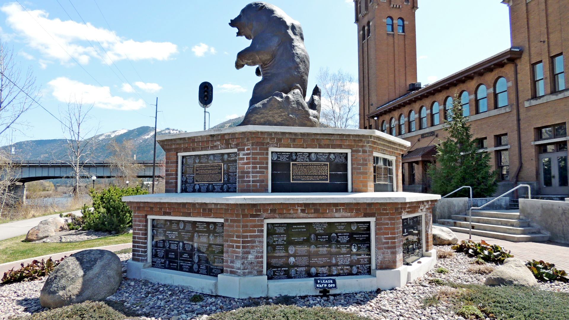
Coordinates given are at the old Milwaukee Depot. Since the trail is actually a loop with dozens of access points, this is as good a place as any to enter as there's a good sized parking lot near the trail. Look for the big bear by the depot, shown below. He's right beside the trail.
Milwaukee Trail Vision
The Chicago, Milwaukee, St. Paul and Pacific Railway
once serviced a line that stretched from Chicago, IL to
Tacoma, WA, passing through Montana and the heart
of Missoula. The Rail-to-Trails Conservancy recognizes
and is promoting the significant opportunity that the
Milwaukee Railroad presents; the ability to create a
cross-continent rail-trail in the West.
In the 1970s the Milwaukee grade was officially
abandoned and properties were sold off. The City of
Missoula has converted some of the old Milwaukee
Road right-of-way into the main east-west spine of its
non-motorized Bicycle Commuter Network. This trail is
made up of the Kim Williams Trail, the south shore of
the Ron MacDonald Riverfront Trail system and the
Milwaukee Trail. Currently the Milwaukee Trail's western
end is at Russell Street and to the east the trail ends
near the Bandmann Flats area. The City plans to
continue acquiring corridor sections for trail expansion
both to the east and west.
Missoula prides itself for being a bicycle and
pedestrian friendly city. A network of commuter trails
and smaller neighborhood and park trails connects
Missoula's parks, shopping centers, civic centers,
schools, places of work and places of play. The core
of Missoula’s Bicycle Commuter Network is built
around two rails-to-trails conversions. The main northsouth
connection, the Bitterroot Branch Trail, runs
parallel to its railroad namesake. The old Milwaukee
Road serves as the east-west commuter connection.
Both the Bitterroot Branch Trail and the Milwaukee Trail
were designed by the local Landscape Architecture
firm Kent Watson & Associates with engineering done
by HDR Engineers.
From Missoula Parks