Augusta County/Rockbridge County
Posted by: Groundspeak Premium Member VirginiaSeeker
N 37° 55.496 W 079° 12.204
17S E 657903 N 4199008
Augusta County and Rockbridge County line.
Waymark Code: WMMT6
Location: Virginia, United States
Date Posted: 08/20/2006
Published By:Groundspeak Regular Member showbizkid
Views: 23

This marker is on the Augusta County/Rockbridge County line with information about each on opposite sides.
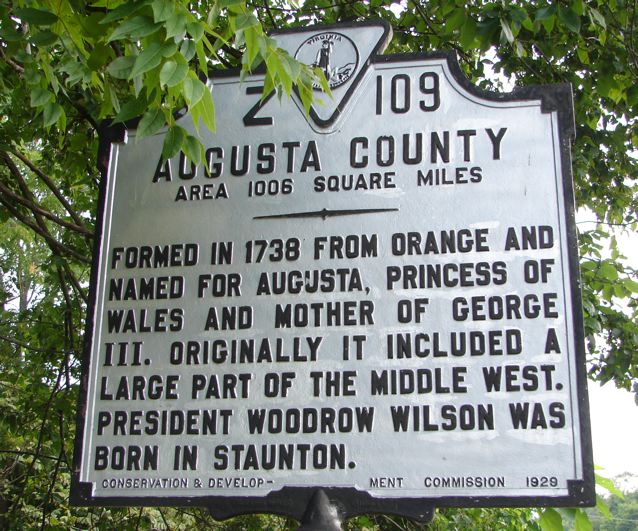
Augusta County

Area 1006 square miles.
~~~~~

Formed in 1738 from Orange and named for Augusta, Princess of Wales and mother of George III. Originally it included a large part of the middle west. President Woodrow Wilson was born in Staunton.
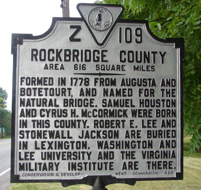
Rockbridge County

Area 616 square miles.
~~~~~

Formed in 1778 from Augusta and Botetourt, and named for the Natural Bridge. Samuel Houston and Cyrus H. McCormick were born in this county. Robert E. Lee and Stonewall Jackson are buried in Lexington. Washington and Lee University and the Virginia Military Institute are there.

Marker Number: Z 109

Marker Title: Augusta County/Rockbridge County

Marker Location: Rt. 11 at Steel's Tavern

County or Independent City: Augusta County and Rockbridge County

Marker Program Sponsor: Conservation & Development Commission, 1929

Web Site: Not listed

Search for...
Geocaching.com Google Map
Google Maps
MapQuest
Bing Maps
Nearest Waymarks
Nearest Virginia Historical Markers
Nearest Geocaches
Create a scavenger hunt using this waymark as the center point
Recent Visits/Logs:
Date Logged Log  
Markerman62 visited Augusta County/Rockbridge County 07/23/2020 Markerman62 visited it
Searcher28 visited Augusta County/Rockbridge County 02/19/2017 Searcher28 visited it
zimage visited Augusta County/Rockbridge County 05/19/2007 zimage visited it

View all visits/logs