1-day long alpine hike to summit of Säntis (2502m / 8209ft ASL) in northeastern Switzerland.
There are many possibilities to hike this mountain from different sides.
Our hike started and finished at southern side - location Alpli near village Wildhaus and then we approached Säntis via exposed Lisengrat.
Mountains
Säntis (2502m / 8209ft ASL) is the highest peak of the Alpstein massif in northeastern Switzerland.
It is also the culminating point of the whole Appenzell Alps, between Lake Walenstadt and Lake Constance.
Shared by three cantons, the mountain is a highly visible landmark thanks to its exposed northerly position within the Alpstein massif.
Säntis is among the
most prominent summits in the Alps and the most prominent summit in Europe with an observation deck on the top.
The panorama from the summit is spectacular. Six countries can be seen if the weather allows: Switzerland, Germany, Austria, Liechtenstein, France, and Italy.
About hike
At the beginning of the round - Alpli - is nice small parkinglot between trees.
Unfortunatelly, it is not for free - as it is usual in Switzerland, you have to spend 5 franks to get ticket from automat.
Make sure you have exact change!
From Alpli we follow road between large idylic pastures, slowly rising towards Säntis massif with dominant peak in front of us.
After a while it starts to climb in serpentines and we are gaining first couple of hundreds metres of today’s elevation difference (more than 1600m up and same down)
All around are large alpine pasture, mainly for cattle. We are passing by two or three sheds and taking few minutes of rest in front of Schafboden mountain chalet.
Here we bought perfect goat cheese. After another hour of hike we finally reach mountain saddle on the main ridge called Rotsteinpass (2124m ASL).
Here you can have good lunch in big mountain hut of same name.
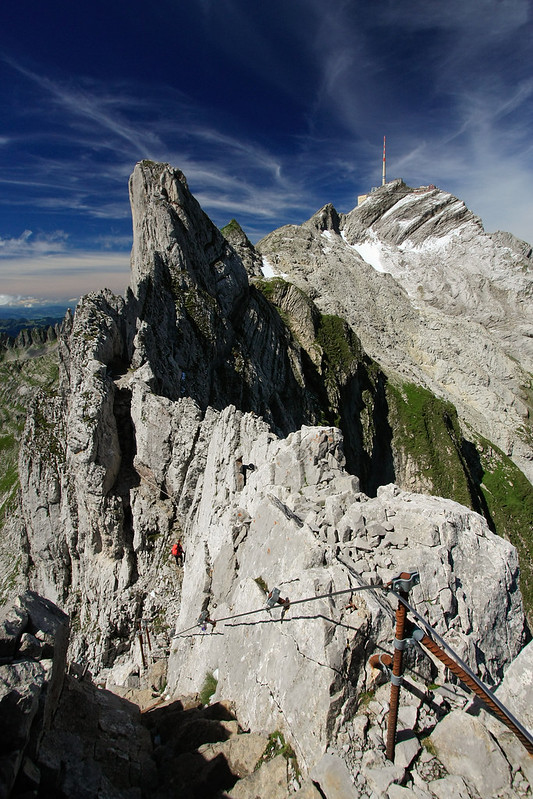 Most thrilling part of the hike is just in front of us: exposed steep rough rocks of Lisengrat.
Trail is well marked by typical red-white signs and jumping up and down through rocks.
Some passages are secured by steel ropes, but it’s not Via Ferrata. These parts can by snowy and icy even in August, so solid hiking boots are absolute must here!
Most thrilling part of the hike is just in front of us: exposed steep rough rocks of Lisengrat.
Trail is well marked by typical red-white signs and jumping up and down through rocks.
Some passages are secured by steel ropes, but it’s not Via Ferrata. These parts can by snowy and icy even in August, so solid hiking boots are absolute must here!
From Lisengrat, it is only few minutes of climb up to Säntis summit with untypical infrastructure on its top.
Huge is 123 metres high transmission tower, surrounded by objects of weather station, restaurant, geology museum, upper station of aerial tramway, hut, observation platform, ..
all connected to impressive building complex.
There are also plenty of tourists on the summit, because it is very easily accessible from opposite, western foot of the mountain - by aerial tramway.
So we do not spend lot of time here and start to descent by steep path, direction Girenspitz.
It’s smaller peak in shadow of Säntis but offers great views to the main peak from different angle.
Then we continue descending to saddle with last mountain chalet - Tierwis.
Terrain is not so nice like in the morning, it’s quite rocky and further down from Tierwis combined with slippy grasses.
But again - nothing really dangerous when weather conditions are good.
Last 2-3 kilometres on paved road is a pleasant variation.
Have a great hike!
Scenic hike facts
| Duration | 9 - 11 hours |
| Terrain characteristics | alpine pastures, then exposed rocks of Lisengrat and Säntis, descent through debris and grassy trails, up to 20% paved road |
| Lenght of the scenic hike | 19.1 kilometres |
| Total Ascent | 1625 metres |
| Total Descent | 1625 metres |
| Highest point | Säntis, 2502m (8209ft) ASL |
| Equipment needed | solid hiking boots to be surefooted, poles, warm clothes, gloves, 5 franks |
| Water availability | available on 4 huts on the trail |
| Season | from May to mid October |
Map
Click on wandermap.net or wanderreitkarte.de to see detailed map of this area.
Parking / transport
It is safe to leave car on small parking-lot at location Alpli (header coordinates).
Parking is not free - there is a machine to buy a ticket before the hike.
Price for full day is 5 franks and you should have exact change.
Overnight
Not needed for this hike, but alternativelly it is possible to sleep on 4 huts on the trail:
Berggasthaus Schafboden, Rotsteinpass,
Alter Säntis and finally Tierwis.
Alternatives
Massif of Säntis can be approach from different directions.
Most often is hiking combined with cablecar (up or down), that is why most of the hikers start and end in recreation center Schwägalp.
This hike from Alpli is less crowdy, beautiful and still doable within 1 day.
Gallery
Visit requirements
Please, log a short story from your hike with few pictures. At minimum, one from Lisengrat and one from another favourite place on the trail, it is up to you!
Wish you a wonderful hike!
Other references
sources: Wikipedia.org, own visit and photos