(fees apply) sits a California historical marker on a circular lawn. The marker reads:
BATTLE ROCK
BATTLE OF THE CRAGS WAS FOUGHT BELOW BATTLE ROCK IN JUNE 1855. THIS CONFLICT BETWEEN THE MODOC INDIANS AND THE SETTLERS RESULTED FROM MINERS DESTROYING THE NATIVE FISHING WATERS IN THE LOWER SODA SPRINGS AREA. SETTLERS LED BY SQUIRE REUBEN GIBSON AND MOUNTAIN JOE DOBLONDY, WITH LOCAL INDIANS LED BY THEIR CHIEF WEILPUTUS, ENGAGED MODOCS, KILLED THEIR CHIEF DORCAS DALLA, AND DISPERSED THEM. POET JOAQUIN MILLER AND OTHER SETTLERS WERE WOUNDED.
CALIFORNIA REGISTERED HISTORICAL LANDMARK NO. 116
PLAQUE PLACED BY THE STATE DEPARTMENT OF PARKS AND RECREATION IN COOPERATION WITH THE ANCIENT AND HONORABLE ORDER OF E CLAMPUS VITUS, TRINITARIANUS CHAPTER #62, JULY 26, 1984.
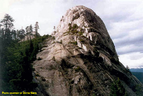
The Location
Battle Rock is in the far northwest corner of Castle Crags State Park. It looks like an upturned thumb and can be seen above Lake Siskiyou and from Interstate 5 just south of Mount Shasta City when traveling south.
The history
Battle Rock earned its name in 1855 in a baptism of blood among Wintu and Modoc warriors, U.S. Army soldiers, Shasta County Sheriff John Driebelbis, gold miners, Mountain Joe, Joaquin Miller, Reuben Gibson and volunteer militiamen.
The battle was sparked when Mountain Joe, also known as Joe deBlondy, spread rumors that the fabled Lost Cabin Mine was somewhere in the area presumably just so his trading post would make money. This caused hundreds of gold-seeking miners to inundate the area almost overnight.
In their mad haste to find the mine, and also while they were searching for placer gold, the goldminers filled the river water with mud, ruining the salmon run that was taking place. In addition, they killed the wild game for their food, and what they didn’t kill was driven away by their excessive noise.
This caused great anger among the Indian people, who were in desperate need of food.
In retaliation, renegade Modoc Indians began attacking travelers on the nearby Oregon Trail. The attacks caused the trail to be too dangerous for any sort of travelers. Authorities closed the trail, making it impossible for mail, supplies and the traveling public to get through. The Indians also burned Mountain Joe’s trading post and cabin at Lower Soda Springs below Castle Crags — and stole his flour, which they carried to their stronghold high up in the rocks of Castle Crags. Little did they know they left a trail of that flour, making it easy to be followed to their camp.
Mountain Joe and Joaquin Miller followed their flour trail up Castle Creek, going as far north as Sisson. They turned back at Sisson and headed back to where their trading post and cabin had been at Lower Salt Creek, all the while spreading the alarm and asking for help to subdue the Indians.
Captain Crook (Fort Crook was later named for him) was the first to try to subdue the Indians. He and his troops arrived from Fort Jones, attacked the Indians at their stronghold, but were turned back when the Indians overpowered them.
The next attack was led by Reuben Gibson (Gibson Road along Interstate 5 in the Sacramento Canyon is named for him). Gibson was married to the daughter of Chief Wielputus, chief of the Shasta Indians, and lived at Portuguese Flat. He had great influence with the local Indians. The Shasta Indians were long-standing enemies of the Modoc Indians.
Chief Wielputus gathered 29 warriors to help fight the battle while Gibson garnered help from Shasta County Sheriff John Driebelbis, Mountain Joe, Joaquin Miller, volunteer militiamen and local gold miners. Gibson led the group up Castle Creek to the Modoc camp high in the crags and completely surprised them in the saddle region of a ridge between Castle Lake and Battle Rock.
The battle was on, and when the bullets and arrows stopped whizzing by, Gibson’s group was victorious.
Indian casualties were high. Two Modoc chiefs were killed in the battle, one man in Gibson’s group was killed, and arrows wounded Joaquin Miller.
This was the last known battle between Indians and whites where the Indians used only bows and arrow, spears and atl-atls. The battle became known as the Battle of Castle Crags and also as the Battle of the Crags.
The present
Battle Rock is now an official historical landmark officially known as California Historical Landmark No. 116. A historical monument memorializing it is inside the Castle Crags State Park entrance across from the guard shack. The plaque was placed July 26, 1984.
Dottie Smith is the author of “The Dictionary of Early Shasta County History”, the book from which this information was extracted. She is the former curator of the Shasta College Museum and instructor of Shasta County History at Shasta College. Check out her daily history blog at www.redding.com and her website at www.shastacountyhistory.com. Contact her at historydottie@yahoo.com.