
Assekonk Borderlands Trail - N Stonington, CT
Posted by:  silverquill
N 41° 26.311 W 071° 53.122
19T E 258938 N 4591457
This is the trailhead for one of many trails through conservation land in North Stonington, Connecticut. There is easy access and parking from Route 2.
Waymark Code: WMMCMW
Location: Connecticut, United States
Date Posted: 08/31/2014
Views: 1

There is ample parking near this trailhead which begins at the south end of the school. A bridge crosses the spillway of Assekonk Swamp and continues over flat land for about 1 1/2 miles.
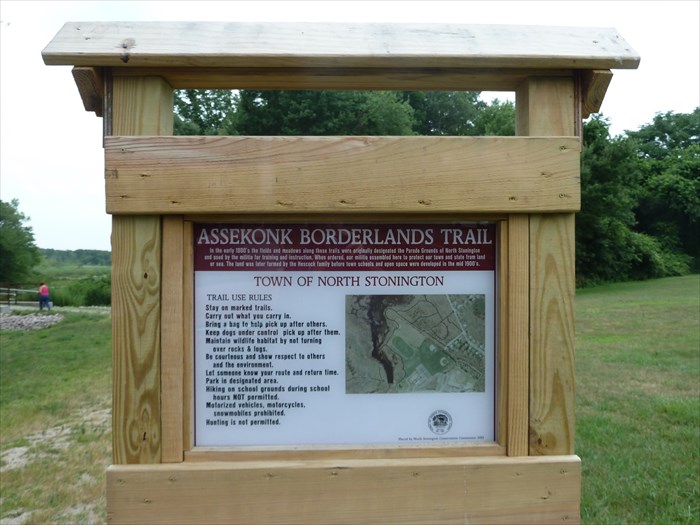
ASSEKONK BORDERLANDS TRAIL
In the early 1800's the fields and meadows along these trails were originally designated the Parade Grounds of North Stonington and used by the militia for training and instruction. When ordered, our militia assembled here to protect our town and state from land or sea. The land was later farmed by the Hescock family before town schools and open space were developed in the mid 19010's
This sign was erected in the fall of 2013. This short description is taken from an article in the Westerly Sun, on Sep. 13, 2013 in an article by staff writer Leslie Rovetti.
"Assekonk Borderlands Trail, which runs between the school property on the western side of Route 2 and Meadow Wood Road in the Kingswood development. A separate trail on that property crosses the Assekonk Swamp and leads to the town’s recreation field on Rocky Hollow Road. The trails are flat and level enough to push a baby carriage on, said Conservation Commission Chairman Bill Ricker, and the entire system of trails is about 1.25 to 1.5 miles long."