
Evan's Ferry 'T' Marker - Rogue River, OR
N 42° 25.868 W 123° 10.328
10T E 485840 N 4697660
This historical 'T' marker is located within John F. Fleming Memorial Park near the Depot Street Bridge in Rogue River, OR.
Waymark Code: WMKRH3
Location: Oregon, United States
Date Posted: 05/22/2014
Views: 9
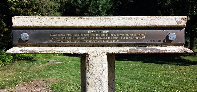
EVAN'S FERRY
Davis Evans established the first ferry this site in 1851. It was known as Jewett's
Ferry, 1853-1861. The 1862 flood destroyed the ferry, but it was replaced.
The Woodville (Rogue River) Bridge was built in 1909. ~ S.O.H.S. - 1979
This marker was placed by the Southern Oregon Historical Society. SOHS has placed a number of these 'T' markers around Southern Oregon and are easily spotted by their painted yellow posts.
I located an online book on all Oregon Ferries since 1828 and it had this to say about Even's Ferry:
Evans Ferry
1851-1854: Davis Evans operated ferries at several locations. According to most contemporary references, the ferry site of Davis "Coyote" Evans was located at the mouth of Evans Creek at the site to become the city of Rogue River in about 1851. The Evans Ferry site was the next settlement up river from the Perkins Ferry. The ferry site was originally called Tailholt, then Woodville then, finally in 1912, City of Rogue River. The ferry and the traffic to and from the gold fields in California and Oregon provided the original focus of the city. According to the Table Rock Sentinal (Southern Oregon Historical Society) Jan/Feb 1992, No. 1, page 28-29). the first ferry consisted of three hewn logs about thirty inches in diameter covered with planks. It measured 8 feet wide x 45 feet long. A double pulley and winch was used to draw the ferry across the river. The cable was secured to an oak tree on one side and a pile of rocks on the other side.
Visit Instructions:
Include your thoughts and observations pertaining to this location and your visit. Provide any additional history that you are aware of that pertains to this location. If the marker commemorates a historic building tell us what it is used for now or share with us the circumstances of an earlier visit to bring this locations history to life.
Please upload a favorite photograph you took of the waymark. Although visiting this waymark in person is the only thing required of you to receive credit for your visit, taking the time to add this information is greatly appreciated.
Be creative.