Bardstown
Posted by: Groundspeak Premium Member ChapterhouseInc
N 37° 48.533 W 085° 27.997
16S E 634979 N 4185717
Bardstown was a planned county seat.
Waymark Code: WMKE1
Location: Kentucky, United States
Date Posted: 08/07/2006
Published By:Groundspeak Premium Member snfromky
Views: 31

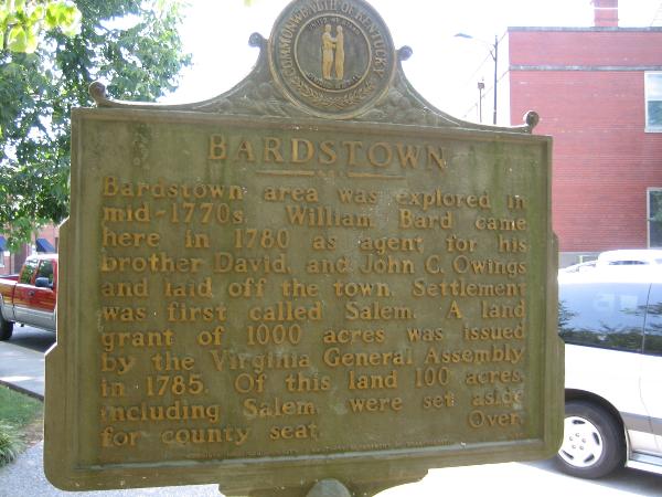
Bardstown area was explored in mid-1770s, William Bard came here in 1780 as agent for his brother David, and John C. Owings and laid off the town. Settlemet was forst called Salem. A land grant of 1000 acres was issued by the Virginia General Assembly in 1785. Of this land 100 acres, including Salem, were set aside for county seat.

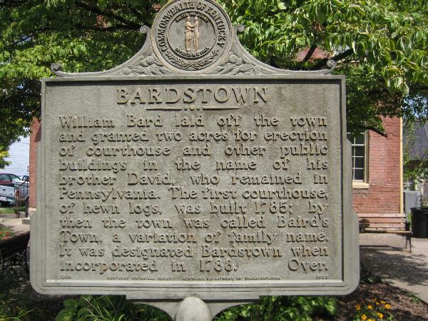
William Bard laid off the town and granted two acres for erection of courthouse and other public buildings in the name of his brother David, who remained in Pennsylvania. The first courthouse, of hewn logs, was built 1785; by then the town was called Baird's Town, a variation of family name. It was designated Bardstown when incorporated in 1788.

Marker Name: Bardstown

Marker Location: City

Type of Marker: Other

Marker Number (for official markers): 1668

Group(s) Responsible for placing Marker:
Kentucky Historical Society Kentucky Department of Transportation


Visit Instructions:
A picture of the site or anything specific to the text on marker.
Search for...
Geocaching.com Google Map
Google Maps
MapQuest
Bing Maps
Nearest Waymarks
Nearest Kentucky Historical Markers
Nearest Geocaches
Create a scavenger hunt using this waymark as the center point
Recent Visits/Logs:
Date Logged Log User Rating  
Markerman62 visited Bardstown 07/10/2017 Markerman62 visited it
PersonsMD visited Bardstown 06/13/2009 PersonsMD visited it
ChapterhouseInc visited Bardstown 08/03/2006 ChapterhouseInc visited it

View all visits/logs