
Boydton and Petersburg Plank Road
Posted by:  showbizkid
N 36° 39.765 W 078° 24.374
17S E 731821 N 4060595
A Virginia State Historic Marker commemorates the Boydton and Petersburg Plank Road, which was located near the marker. The plank road was built between 1851 and 1853, but by 1860 most of the road was declared unsafe. It had received too much use and was built of poorly suited timber.
Waymark Code: WMJYT
Location: Virginia, United States
Date Posted: 08/02/2006
Views: 28
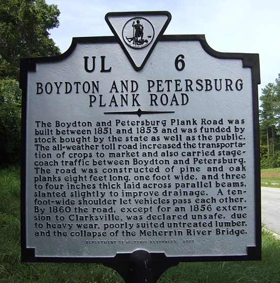
The marker text reads:
The Boydton and Peterson Plank Road was
built between 1851 and 1853 and was funded by
stock bought by the state as well as the public.
The all-weather toll road increased the transporta-
tion of crops to market and also carried stage-
coach traffic between Boydton and Petersburg.
The road was constructed of pine and oak
planks eight feet long, one foot wide, and three
to four inches thick laid across parallel beams,
slanted slightly to improve drainage. A ten-
foot wide shoulder let vehicles pass each other.
By 1860 the road, except for an 1856 exten-
sion to Clarksville, was declared unsafe, due
to heavy wear, poorly suited untreated lumber,
and the collapse of the Meherrin River Bridge.To record your own visit to this waymark, take and post your own photo of the waymark with your log. Logs must contain an original photo as proof of your visit, please.