|
 CONFLUENCE - Ipel into Danube river - Chlaba, Slovakia Posted by:  Rikitan Rikitan
N 47° 49.102 E 018° 50.881
34T E 338912 N 5298354
Confluence of one of the major slovak rivers - Ipel into into wide waters of Danube - at slovak-hungarian border near villages of Chlaba (Slovakia) and Szob (Hungary).
Waymark Code: WMJM9V
Location: Nitriansky kraj, Slovakia
Date Posted: 12/03/2013
Views: 10

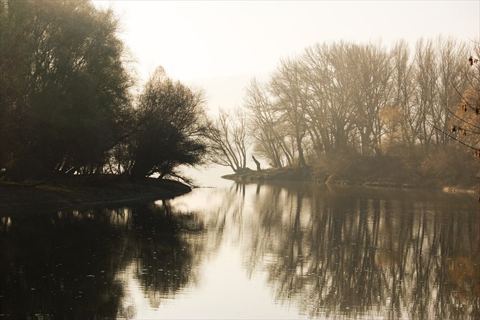
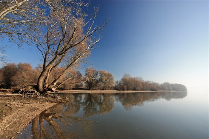
Confluence of Danube and Ipel river can be visited near village Chlaba on border with Hungary.
Right shore of Ipel (flowing into Danube) is in Slovakia, left one in Hungary .. while left shore of Danube lies in Slovakia and right one is Hungarian.
On above coordinates you can watch last metres of river Ipel from Slovak shore, flowing to large trough of Danube river.
From its origin, Ipel descended 596 metres over 232.5 kilometres of its lenght (out of that 140 kilometres as a border river between Slovakia and Hungary).
Ipel is taking smaller rivers and streams from its basin of area 5151 square kilometres.
.: Danube :.
The Danube (Dunaj, in Slovak) is a river in Central Europe, the European Union's longest and the continent's second longest (after the Volga).
Classified as an international waterway, it originates in the town of Donaueschingen (the Black Forest of Germany) at the confluence of the rivers Brigach and Breg.
The Danube then flows southeast for 2,872 km (1,785 mi), passing through four Central European capitals before emptying into the Black Sea via the Danube Delta in Romania and Ukraine.
Once a long-standing frontier of the Roman Empire, the river passes through or touches the borders of ten countries: Romania (29.0% of basin area), Hungary (11.6%), Serbia (10.2%), Austria (10.0%), Germany (7.0%), Bulgaria (5.9%), Slovakia (5.9%), Croatia (4.4%), Ukraine (3.8%), and Moldova (1.6%).
Its drainage basin extends into nine more.
From Danube source to its outlet into the Black Sea, river Ipel is its 12th main tributary.
.: Ipel :.
Ipe¾ (Slovak) or Ipoly (Hungarian) (German: Eipel, archaic Slovak: Jupo¾ ) is a 232.5 km long river in Slovakia and Hungary, tributary to the river Danube.
Its source is in central Slovakia in the Slovenské rudohorie Mountains.
It flows south to the Hungarian border, and then southwest, west and again south along the border until it flows into the Danube near Szob.
Ipe¾ flows through or makes border of Banská Bystrica and Nitra regions in Slovakia, and Nógrád and Pest counties in Hungary.

Sutok Dunaja a Ipla je mozne vidiet na vlastne oci nedaleko dedinky Chlaba na slovensko-madarskych hraniciach.
Lavy breh Ipla lezi u nas, kym pravy je za vodou v Madarsku, v opacnom garde to plati aj pre Dunaj.
Na tomto neskonale pokojnom mieste Ipel vteka do Dunaja po 232 a pol kilometra dlhej puti od jeho pramena vo Veporskych vrchoch.
Prekonal vyskovy rozdiel 596 metrov a odviedol riecky a potoky z plochy 5151 kilometrov stvorcovych, co je viac ako desatina rozlohy Slovenska.
.: Dunaj :.
Dunaj je druha najdlhsia europska rieka a najdlhsia rieka v Europskej unii.
Vznika sutokom Brege a Brigachu v Ciernom lese (Nemecko), preteka juznym Nemeckom, Rakuskom, Slovenskom, Madarskom, Srbskom, potom tvori po mnoho desiatok kilometrov rumunsko-bulharsku hranicu a usti deltou do Cierneho mora na hraniciach medzi Rumunskom a Ukrajinou.
Dunaj preteka 10 nasledovnymi krajinami v smere od pramena do ustia: Nemecko, Rakusko, Slovensko, Madarsko, Chorvatsko, Srbsko, Rumunsko, Bulharsko, Moldavsko a Ukrajina.
Ipel je jeho dvanastym z hlavnych riecnych pritokov.
.: Ipel :.
Ipe¾ (mad. Ipoly, nem. Eipel) je jedna z dlhsich riek Slovenska a lavostranný pritok Dunaja.
Prameni vo Veporskych vrchoch (presnejsie v Sihlianskej planine) nedaleko Lomu nad Rimavicou,
spociatku tecie na juh, pri Velkej nad Iplom dosahuje slovensko-madarské hranice, za Kovacovcami sa toci na zapad, preteka popri Balazskych Darmotach a Sahach,
pri Kubanove sa zase toci na juh a pri Chlabe usti do Dunaja.
Celková dlzka rieky je 232,5 km, z toho 140 km tvori hranicu s Madarskom.
Celkovy spad je 596 m. Prietok vody je nestaly, priemerny prietok v usti je 21 m3/s. Plocha povodia je 5 151 km stvorcovych.
Parking Coordinates: N47°49.529' E18°51.084'

Trailhead Coordinates: N47°49.43' E18°51.136'
Relevant Web Site: [Web Link]
|
Visit Instructions:
1. Describe your journey and visit.
2. Date of your visit.
3. At least one original photo (DO NOT include either you or your GPSr).
Recent Visits/Logs:
| There are no logs for this waymark yet. |
|
|
|
|