|
 Turnagain Heights Slide - Earthquake park - Anchorage, AK Posted by:  Lat34North Lat34North
N 61° 11.911 W 149° 58.802
6V E 339868 N 6788550
This marker is located in Earthquake Park located on W Northern Lights Blvd. It is also accessible from the Tony Knowles Bicycle Trail.
Waymark Code: WMJ25T
Location: Alaska, United States
Date Posted: 09/11/2013
Views: 8
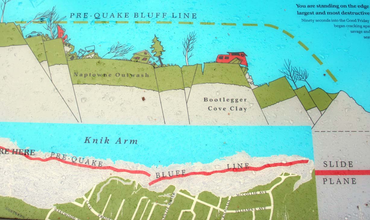
Turnagain Heights Slide
You are standing on the edge of the Turnagain Heights Slide, the largest and most destructive landslide in Anchorage.
Ninety seconds into the Good Friday Earthquake, an 8,000-foot strip of bluff, 1,200 feet wide began cracking apart into larger blocks which slid toward Cook Inlet. With a savage and grinding roll, the slide transported some homes 500 feet seaward, and broke apart or crushed other homes. Residents rushed outside their homes only to be thrown to the ground as the blocks pulled apart and heaved around them. Others were trapped in their homes. The slide movement continued for 90 seconds after the earthquake stopped shaking Anchorage. Over 12 million cubic yards of sand, clay and gravel slid off toward the inlet, 75 homes were destroyed, and four people perished.
Bootlegger Cove Clay
Underneath most coastal Anchorage is a deep layer of gray- blue material called Bootlegger Cove Clay. This silty plastic clay is composed of estuary-miarine sediment, and was deposited 15,000 to 30,000 years ago by massive glaciers that covered most of south-central Alaska. Unfortunately, it can be extremely [? soft and ?] unstable. During an earthquake Bootlegger Cove Clay tends to liquefy and lose strength and where the upper clay layers contain loose sand layers, it can dramatically fail.
Some of the text was hard to read, the section between the [? soft and ?] is my best guess at how the marker reads.
More Information:
You Tube video: Great Alaskan earthquake of 1964
AEIC: Alaska Earthquake Information Center - The Great Alaska Earthquake of 1964
ASK - 1964 Alaska earthquake
Wikipedia - 1964 Alaska earthquake
Wikipedia - Megathrust earthquake
Wikipedia - Slump (geology)
Wikipedia - Tsunami
Wikipedia - Cook Inlet
Marker Name: Turnagain Heights Slide

Marker Type: Roadside
Addtional Information:
The Great Alaskan Earthquake occurred on Good Friday, March 27, 1964 at 5:36 P.M. AST. It was a 9.2 megathrust earthquake. The earthquake also caused a destructive tsunami.
"Various sources indicate that about 131 people died as a result of the earthquake: nine as a result of earthquake itself, 106 from subsequent tsunamis in Alaska and 16 from tsunamis in Oregon and California. Property damage was estimated at over $310 million ($2.22 billion in current U.S. dollars)."
Source: Ask: 1964 Alaska earthquake
http://www.ask.com/wiki/1964_Alaska_earthquake?o=2801&qsrc=999&ad=doubleDown&an=apn&ap=ask.com
Date Dedicated / Placed: Not listed
Marker Number: Not listed
|
Visit Instructions:
Preferred would be to post a photo of you OR your GPS at the marker location. Also if you know of any additional links not already mentioned about this bit of Alaska history please include that in your log.
|