
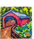
Thomas Mill Covered Bridge - Philadelphia, PA
N 40° 04.313 W 075° 13.537
18T E 480761 N 4435759
This is the last covered bridge within the city limits of Philadelphia & the only covered bridge within the city limits of any major U.S. city. The bridge underwent extensive rehabilitation in 1999 so it will be here for another hundred years.
Waymark Code: WMHZWZ
Location: Pennsylvania, United States
Date Posted: 09/02/2013
Views: 3
 .....
..... .....
..... .....
..... .....
..... .....
..... .....
.....
The bridge is fairly typical in design and color of what you would find in Lancaster County's covered bridges with a few notable exceptions. This bridge is very long, longer than most and has two sides for both traffic lanes. I have never seen one of those before. The other oddity is the bridge appears to be private. One side was closed with warnings posted on the entrance about how unsafe it is due to age and buckling wood floor boards. The other end has a flimsy, plastic, orange 'fence' blocking the opening. At the far end, away from the entrance was farm equipment being stowed away for the winter.
This is Amish country so I was behind some horse-drawn wagons for a time. If you look on GoogleEarth, you'll see farmlands forever. The property this is on is a farmstead. Across the creek is a beautiful, functioning waterwheel. at first, I thought this site was a state or local park with the way it is set up. Whatever it is park on the dirt road near the side that is open. The Lincoln Highway is .4 mile from here. I only found this because there was a detour and I was forced to travel south, then west to avoid a section of the Lincoln that had been closed.
My good buddies at Wikipedia tell me Herr's Mill Covered Bridge was built in 1844 by Joseph Elliot and Robert Russell at a cost of $1787. It has a double-span, double-arch Burr arch truss construction. In 1875 the bridge was rebuilt by James C. Carpenter at a cost of $1860. The bridge was later bypassed by a new concrete bridge and is now on the private property of the Mill Bridge Village Camping Resort. In 2006, after plans to demolish the bridge were reported, owner Brian Kopan was quoted as saying "The bridge is in fine condition. We’re hoping to keep it as it is."
Dimensions
Length: 178 feet (54.3 m) total length
Width: 15 feet (4.6 m) total width
And so, without further ado, here is a list of my seven waymarks, in descending category order, now all new with HOT LINKS.
05. Thomas Mill Covered Bridge - Philadelphia, PA
06. Thomas Mill Covered Bridge - Philadelphia, PA
09. Wissahickon Valley - Philadelphia, PA
10. ONLY -- Covered Bridge in a Major U.S. City - Philadephia, PA
13.
Thomas Mill Covered Bridge - Philadelphia, PA
14. Thomas Mill Covered Bridge - Philadelphia, PA
15. For City's Red Covered Bridge, A Major Rehab Over Summer - Philadelphia, PA
* Listings reflect new department-category alignment.
01. Animals
02. Buildings
03. Business
04. Culture
05. Entertainment
06. History
07. Measurement Standards
08. Monuments
09. Nature
10. Oddities
11. Recreation
12. Signs
13. Structures
14. Technology
15. Waymarking Multifarious