
Ligonier, Pennsylvania
N 40° 14.577 W 079° 14.232
17T E 649940 N 4456212
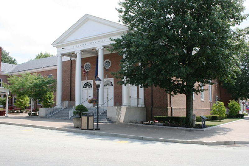
Ligonier, in Westmoreland County, Pennsylvania has a population was 1,573 and was settled in the 1760s. The Town Hall is located at 120 East Main Street.
Waymark Code: WMHZG3
Location: Pennsylvania, United States
Date Posted: 08/31/2013
Views: 1
Ligonier, Pennsylvania
Informaion excerpted from Wikipedia
In 1758, when British forces launched a major campaign to remove French forces from the forks of the Ohio, now Pittsburgh, this spot on Loyalhanna Creek was the site of their westernmost camp before reaching the Ohio. It was an enormous army, a virtual moving city of 6,000 people, that temporarily made this the most populated spot in Pennsylvania second only to Philadelphia. The fort was named Fort Ligonier after John Ligonier, a British noble of French origin who held the rank of Field Marshal in the British Army. Eventually, the name of the settlement that grew up around the fort was shortened to Ligonier.
In 1817, the Philadelphia-Pittsburgh Turnpike was completed, a gravel road that was the precursor to today's US Route 30. Fort Ligonier was a logical place for travelers to break their journey, and with such commercial opportunities in mind, a local resident named John Ramsay (sometimes spelled Ramsey) laid out the street plan, including the space now known as the Diamond. He initially called the town Ramseytown, later changed to Wellington (after the Duke of Wellington), and finally the name was changed to Ligonier. Several decades of prosperity followed. On April 10, 1834, Ligonier was incorporated as a borough.
However, in 1852 the Pennsylvania Railroad was completed, which avoided Ligonier and passed through Bolivar and Latrobe instead. Traffic shifted from horse-drawn vehicles to the railroad, causing the community's population to drop to 350 according to the 1860 census. A quarter-century of stagnation ensued as the town withered.
Ligonier enjoyed a new impetus when the Ligonier Valley Railroad was completed in 1877, linking the community to Latrobe where connections to the Pennsylvania Railroad were possible. The Ligonier Valley Railroad enabled lumber, coal, and quarried stone to be transported out of the Ligonier Valley, which spurred development of the town. Also, the railroad made it easier for Pittsburgh residents to visit Ligonier, causing the town to develop as a summer resort. Some major physical changes to Ligonier occurred during this period. In 1894, the Diamond, which had been used as a corral for horses and wagons, was transformed into a park with a bandstand. A large hotel, the Hotel Breniser, was built in 1900 where the town hall currently sits. In 1909-1910, the Ligonier Valley Railroad built an ornate station and headquarters building, which still stands at 339 West Main Street.
In 1952, the Ligonier Valley Railroad ceased operation, due to a combination of overlogging, decline of the coal industry, and the loss of passenger traffic to motor vehicles.
The Pittsburgh, Westmoreland and Somerset Railroad also served Ligonier from 1899 to 1916, although it did not enjoy the success of the Ligonier Valley Railroad.
Ligonier has three listings on the National Register of Historic Places: the Fort Ligonier at 216 South Market Street; the Ligonier Historic District, which encompasses the Diamond and the oldest parts of the borough; and the demolished Ligonier Armory.
Ligonier and its surrounding countryside are strongly associated with the Mellon banking family, which still owns considerable tracts of land in the area. The Huntland Downs estate, near Ligonier, comprises some 30,000 acres of land and is the centerpiece of the Mellon land holdings in the region.
The Town Hall was built in 1967 and was of Ligonier's downtown experienced "colonialization" in the late 1960s to early 1970s, part of a general face-lifting campaign promoted by the local Chamber of Commerce. This campaign coincided with, and was influenced by, the first master plan for the borough completed in 1962 by the Pittsburgh Regional Planning Association. Among other suggestions, it recommended a more coherent design theme for buildings around the diamond. This drive was aided substantially by the patronage of Richard King Mellon whose foundation underwrote the construction or alteration of several prominent buildings on the diamond