
Semmes’ Brigade served as a member of McLaws’ Division in the First Corps, Army of Northern Virginia. The unit was commanded by Brig. Gen. Paul Jones Semmes (June 4, 1815 – July 10, 1863) who was a banker, businessman, and a Confederate general in the American Civil War. Semmes was mortally wounded in the thigh while leading a charge across the Wheatfield at the Battle of Gettysburg on July 2, 1863. He died eight days later in Martinsburg, West Virginia, and was buried in Linwood Cemetery in Columbus. Shortly before his death, Semmes told a war correspondent, "I consider it a privilege to die for my country."
The Advance Position Marker is located on the right or east side of Brooke/Cross/De Trobraind Avenue if traveling north along the road. This area is called Rose Woods. The  53rd Pennsylvania Infantry Monument is directly across the road (diagonally) from this tablet.
 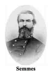 Parking is available up here at large shoulder areas on the side of the road. Take care to not park on anything remotely green looking as Park Police will happily ticket you. I visited this site on Monday, July 1, 2013 on the 150th anniversary of the Battle of Gettysburg after 5 PM, EDT. As always, I used my trusty and oft abused Canon PowerShot 14.1 Megapixel, SX210 IS digital camera for the photos.
This position tablet is a secondary marker. The primary monument called the Semmes' Brigade - CS Brigade Tablet (MN693) is located West Confederate Avenue, on the right or west side of traveling west. To the rear or north of this position is the Confederate Avenue Observation Tower as well as the parking lot.
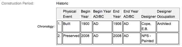
These cast iron monuments were first built in 1900 and concluded in 1906 according to the NRHP nomination form as well as the on-line Commission Report archives. 1906 seems to be the most reasonable, extremely conservative date so we will go with that. I have found these tablets mentioned as early as 1902 in the yearly Commission reports with regards to the contracts being awarded. From then on, the tablets were completed in bunches each year as the budget dictated. The work was done under the direction of the Gettysburg National Park Commission (established by the United States Department of War), after they took over the administration of the park from the Gettysburg Battlefield Memorial Association (whose funds had expired) on March 3, 1893, and whose stewardship was then transferred to the National Park Service in 1933. SOURCE
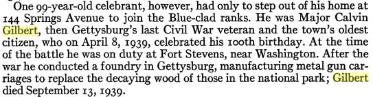
These advance position markers were cast by Calvin Gilbert. Gilbert joined the 87th Pennsylvania Volunteers when the "Rebellion" broke out. Since he was musically inclined, he was made a member of the regimental band. In early 1863, he was promoted to the rank of Captain and sent to Washington D.C. for commissary duty. He served in that capacity until the war ended in 1865, and at war’s end earned the brevet rank of Major. 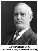 After returning home to Gettysburg, Major Gilbert moved his family to the town of Chambersburg, where he served as the Superintendent of Schools. He also opened an iron foundry there in 1868. When Calvin learned, nearly thirty years later, in 1894, that the Gettysburg Foundry was available, he purchased it with a business partner & moved his family back to Gettysburg. For the next twenty years, the Calvin Gilbert Foundry created ironworks that are still seen today on many historic forts and national battlefields (this tablet), from upstate New York to Florida to Lookout Mountain. Gilbert lived to be 100 years old and attended the Last Reunion of the Blue and Gray for the 75th anniversary of the Battle of Gettysburg when he was 99. He was a most remarkable man and lived an amazing life.
There is an excellent excerpt in the American Guide Series about Gilbert attending the 75th reunion anniversary.
Look carefully on the reverse side of one of these tablets and his name might be there. The inscription on the tablet reads:
 Army of Northern Virginia
Longstreet's Corps McLaws's Division
Semmes's Brigade
10th. 50th. 51st. 53d.
Georgia Infantry
July 2 Arrived on the Field about 3.30 p.m. Advanced about 5 o'clock in support of Kershaw's and Anderson's Brigades and took an active part in the conflict on Rose Hill and in the ravine and forest East of there and in the vicinity of the Loop. Participated in the general advance late in the evening by which the Union forces were forced out of the Wheatfield and across the Plum Run Valley. Brig. General Paul J. Semmes fell mortally wounded in the ravine near the Loop.
There are hundreds of non-sculpted monumentation for the various Confederate States & Union units who fought at Gettysburg. There are about 10 different variations of tablets, markers and monoliths by my reckoning. Six designs represent brigade (2), division (2), corps (2), & army headquarters (2), each different in a subtle way so as to distinguish between armies. Battalion/battery/advance position markers and regimental monuments for United States Regulars & Confederate have their own distinct design (2), bringing the total to ten designs at the battlefield. The bronze tablets (the brigade monuments) were created by Albert Russell & Sons Co. of Newburyport, Massachusetts. The granite bases which accompany the various tablets were created by the Van Amringe Company out of Boston, Massachusetts. The cast iron tablets were of course manufactured by the aforementioned Calvin Gilbert. The 1910 Gettysburg Commission report lists the awarded contracts to these companies (not Gilbert) for the tablets.
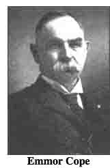 All of these tablets were designed by architect Colonel Emmor Bradley Cope (July 23, 1834 - May 28, 1927). He designed pretty much every tablet for both the Union and Confederate armies, each one distinct, with several different varieties. He is buried in Evergreen Cemetery in Gettysburg, as well he should be as this park and most of the things seen here today were designed by him and as such, are his legacy.
These monuments/tablets were erected just after the turn of the century during the first and beginning of the second decade of the 20th century. Each one has since been preserved or restored at least twice since the turn of the 21st century. The plaques and tablets were erected by the Gettysburg Park Commission (established by the War Department). The Gettysburg Park Commission is also referred to as the Gettysburg National Military Park Commission or the Gettysburg National Park Commission, to clear up any confusions, especially my own.
On October 1, 1898, the Gettysburg National Park Commission in a letter to the Secretary of War gave recommendations for continuing the task of organizing and progressing the work of the Gettysburg National Military Park. Every November they wrote their annual report which outlined the work of the GNPC for that year. The following is an excerpt from that report relevant to this waymark. The link at the end of the paragraph will take you to the entire report. The method of marking the positions of troops on this field, as approved by the War Department, is to place the principal tablet or monument of each command at the position occupied by the command in the main line of battle, and to mark the several important positions subsequently reached by each command in the course of the battle by subordinate and ancillary tablets, with appropriate brief inscriptions giving interesting details and occurrences and noting the day and hour as nearly as possible. SOURCE
Most of the Commission reports have been digitized and can be found HERE. The initial 1893 report up to and including 1921 can be found here. 1922 to 1926 are missing and have yet to be discovered. The years 1927 to 1933 were discovered in 1996 and are also included. To my knowledge this is the most comprehensive list of documents that illustrated the development and formation of the park.
Information about these specific types of monuments:
CONFEDERATE BATTERY TABLETS (ADVANCE POSITION MARKERS)
These tablets are 3’8" x 3’4" in dimensions, with carefully prepared inscriptions cast in raised letters painted in white (contrasting the black background) describing the part taken in the battle by each artillery battery, their position and stating its numbers and losses so far as practicable to obtain. Most of the CS battery markers state the losses were not reported in detail. The brigade which each battery served under is written first on the tablet, then proceeded by the battery name, usually accompanied by some colorful artillery name. They are mounted on iron pillars or fluted cast iron posts about 3 feet high, grouted in the ground, and the tablets are inclined at a suitable angle so that the inscriptions can easily be read by persons riding or driving on the avenue. Every tablet is 4’4" in height. SOURCE & SOURCE. These tablets usually have accompanying artillery pieces which flank the tablet on either side. There can be as little as one cannon and as many as four. The cannons usually represent the battery and the armaments that specific battery used at Gettysburg. The cannons presumably point in the same direction as they once fired at the enemy in 1863. Sometimes only the cannon pads are present as the guns are periodically removed for service, cleaning, restoration, maintenance, etc.
The Semmes' Brigade Advance Position Marker is a contributing feature to the Gettysburg National Military Park Historic District which is nationally significant under NR Criteria A, B, C & D. Areas of Significance: Military, Politics/Government, Landscape Architecture, Conservation, Archeology-Historic. Period of Significance: 1863-1938. The original National Register Nomination was approved by the Keeper March 19, 1975. An update to this nomination was approved by the Keeper on January 23, 2004. The monument is catalogued as contributing structure number MN549.
From the Nomination Form:
1 of 100 Civil War tablets in the park locating the positions of batteries and brigades not otherwise marked by monumentation. Marks position of Semmes CS Brigade Advance on July 2, 1863. Narrates events associated w/ Brigade during Battle.
Short Physical Description:
Cast iron tablet, 3'8" x 3'4", with raised inscription painted in a contrasting color and mounted on fluted cast iron post. All 4'4" H. Cast by Calvin Gilbert.
Long Physical Description:
Located on W side of Brooke Ave.
My Sources
1.
NRHP Nomination Form
2.
Stone Sentinels
3.
Virtual Gettysburg
4.
Draw the Sword
5.
Historical Marker Database
6.
Wikipedia