
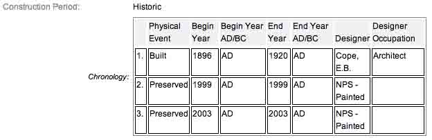
There are a several dozen of these old, cast iron markers, most constructed and erected in 1896. E.B. Cope, architect designed all of these markers as well as the tablets and historical markers, also made of cast iron. They were all constructed by War Department. The avenue , house & site markers are low to the ground, roadside and help to identify the various road systems as well as farmhouses and other physical structures and buildings which play an important role in the historic district. Each marker is painted black with white letters.
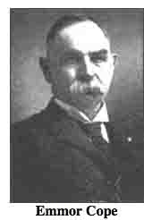 The architect of Gettysburg and of these cast iron ID tablets, Colonel Emmor Bradley Cope (July 23, 1834 - May 28, 1927), designed all non-sculpted monumentation for Union and Confederate armies, each one distinct, with several different varieties as well as the road systems used to carry people to see the various monuments. He is buried in
  Evergreen Cemetery in Gettysburg, as well he should be as this park and most of the things seen here today were designed by him and as such, are his legacy.
The cast iron tablet is located on the left or southwest side of Cross/De Trobraind Avenue if traveling west along the road, diagonally across from the Anderson's Brigade Advance Position Marker (MN550). Parking is available up here at large shoulder areas on the right side of the road. Take care to not park on anything remotely green looking as Park Police will happily ticket you. I visited this site on Monday, July 1, 2013 on the 150th anniversary of the Battle of Gettysburg after 5 PM, EDT. As always, I used my trusty and oft abused Canon PowerShot 14.1 Megapixel, SX210 IS digital camera for the photos.
Brooke Avenue was laid out by the War Department in 1906. It is a one way paved road which starts as Cross Avenue at the intersection of Ayers and Sickles Avenues. It turns into DeTrobriand Avenue, which terminates at Sickles Avenue in the Wheatfield. Traffic eventualy exits to Wheatfield Road. The avenue is named after Colonel John R. Brooke, commander of the 4th Brigade in the First Division of the Union Second Corps. His brigade charged to this location on the afternoon of July 2nd and briefly held the position. There are five Union regimental monuments, one Union headquarters monument, and two Confederate brigade markers along Brooke Avenue. They are clustered together in a relatively small area under the beautiful trees of the Rose Woods. SOURCE
Collectively however, the road is cataloged as Cross, Brooke, and DeTrobriand Avenues as the road, which is an irregular circle starting and ending at Sickles Avenue, takes on different monikers depending on which part of the road was defended by which general during the Battle of Gettysburg. Clearly, a very economical way to squeeze in as many names of the battle as possible. According to the NRHP narrative, the avenues measure 0.787 miles long by 16' wide. It is constructed of bituminous treated macadam with telford base. It starts south in Rose Woods at Sickles and Ayres Avenues and loops back northwest to Sickles Avenue, at lower end of the Wheatfield. Constructed by the War Department, DeTrobriand Avenue extends along the stone wall and designates the position held by DeTrobriand’s troops on July 2. Brooke Avenue designates position where Brooke’s Brigade advanced on July 2. Cross Avenue designates area where Cross’ Brigade was engaged on July 2.
It's always interesting to ding into the annual Commission reports to learn exactly when and how certain roads or monuments came to be. This road was originally just called Brooke Avenue. By the end of the 1905 fiscal year, the June 30, 1905 Report first began to contemplate the building of this road and then the eventual survey and staking out of it as well. The purchase of Bair’s woods, formerly a part of the Rose farm, which was accomplished during the fiscal year, makes it possible to build an avenue on some of the most important grounds of the battlefield. There is now in contemplation the construction of an avenue over this ground. The line commences at the wheat field, running in a southwesterly direction ...intersecting Sickles avenue at the wheatfield woods; total distance of about 1 mile. It will pass near to 34 marked Union regimental positions, 4 unmarked Confederate brigades, and 1 unmarked Union brigade.
The July 20, 1906 Commission Report informs the War Department/Congress On January 19, 1906, a survey was commenced for the purpose of discovering the best line, ground, and grade for an avenue to open important Union and Confederate positions and battle lines south of the Wheat Field and through Rose Grove along the advanced position of Brooke's brigade, July 2, 1863. This part of the field has been very difficult of access heretofore. The proposed avenue is intended to remedy this difficulty. A very good grade was found upon ground recently purchased by the United States from J. Emory Bair. In January and February, 1906, the avenue was located permanently and staked. Bids have been received for grading and piking the avenue; action upon it is now pending. The avenue to be piked will be 5,858 feet long and 16 feet wide, stonework 14 inches deep, built on the Telford system. No grade upon it is over 4 degrees.
Finally, the July 1, 1907 Commission Report reported to the Secretary of War the road was completed and opened. Brooke avenue was completed and opened to the public on April 1. It traverses and opens a very important part of the battlefield. There are now on the line of this avenue sixteen large regimental monuments, as follows....
The Brooke Avenue ID Tablet is a contributing feature to the Gettysburg National Military Park Historic District which is nationally significant under NR Criteria A, B, C & D. Areas of Significance: Military, Politics/Government, Landscape Architecture, Conservation, Archeology-Historic. Period of Significance: 1863-1938. The original National Register Nomination was approved by the Keeper March 19, 1975. An update to this nomination was approved by the Keeper on January 23, 2004. This roadside marker is listed as contributing structure number ID05.
From the nomination form
Part of post-Civil War development of battlefield which now contributes to the commemorative landscape. Constructed by War Department to mark Brooke Avenue.
Short Physical Description:
2, Painted raised letter and border inscription tablet, 2'9"x1'8". Mounted on fluted post, 3' high. Located at in division between Cross and Brooke and at the division between Brooke and DeTrobraind.
Long Physical Description:
N/A
Source
1.
NRHP Narrative
2.
Stone Sentinels
3.
Draw the Sword
4.
Gettysburg365