
G. Weikert House - Cast Iron Site ID Tablet - Gettysburg National Battlefield Historic District - Gettysburg, PA
N 39° 48.123 W 077° 14.078
18S E 308693 N 4408175
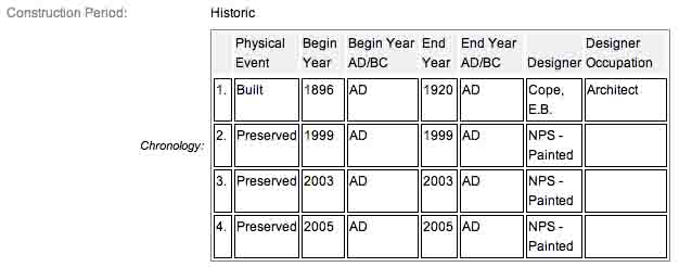
This is one of thirty-five site location tablets, made of cast iron, denoting important houses and sites around the battlefield. They were erected circa 1896 by the War Department as the development and preservation of the park moved into full gear.
Waymark Code: WMH9NR
Location: Pennsylvania, United States
Date Posted: 06/11/2013
Views: 4

There are many of these old, cast iron markers, most constructed and erected in 1896. E.B. Cope designed all of these markers as well as the tablets and historical markers, also made of cast iron. They were all constructed by War Department. The avenue markers and house markers are low to the ground, roadside and help to identify the various road systems as well as farmhouses and other physical structures and buildings which play an important role in the historic district and which saw "action" during the Battle of Gettysburg. Each marker is painted black with white letters.
These 61 cast iron tablets identify the names of the commemorative avenues in the park. Raised letters and the raised border of the tablet are painted a contrasting color to the black of the painted tablet. Each tablet is mounted on a fluted post and set at the terminus of the avenues. Designed by E. B. Cope. (NRHP narrative)
This tablet is to the far (proper) right or northeast of the house, stuck in the grass, To the eft of it is a rick wall, to the right, United States Avenue and to the front, the white Picket fence surrounding the east yard, about 45 feet away and 108 from the house. The George Weikert Farm Summer Kitchen is at the corner where United States Avenue, Sedgwick Avenue and Slocum Avenue all come together. It is one of several Weickert farms in the area at the time of the battle, with three belonging to George's sons and another to a distant cousin. The farmstead in on the left or south side of the Avenue if traveling east along United States Avenue. The barn is about 150 feet from the road. I visited the interpretive on Thursday, July 5, 2012 @ 5:25 PM, EDT & @ an altitude of 555 feet, ASL. I used a Canon PowerShot 14.1 Megapixel, SX210 IS digital camera for the photos.
All the roads, avenue markers, house markers and the wide variety of Union & Confederate tablets seen around the battlefield and lining these avenues were designed by this architect, Colonel Emmor Bradley Cope (July 23, 1834 - May 28, 1927). He is buried in Evergreen Cemetery  in Gettysburg, as well he should be as this park and most of the things seen here today were designed by him and as such, are his legacy.
The G. Weikert House - Cast Iron Site ID Tablet are a contributing feature to the Gettysburg National Military Park Historic District which is nationally significant under NR Criteria A, B, C & D. Areas of Significance: Military, Politics/Government, Landscape Architecture, Conservation, Archeology-Historic. Period of Significance: 1863-1938. The original National Register Nomination was approved by the Keeper March 19, 1975. An update to this nomination was approved by the Keeper on January 23, 2004. This roadside marker is listed as contributing structure number ID74.
From the Nomination Form:
1 of 35 Site ID Tablets by War Dept's post-Civil War development of battlefield that now contributes to the commemorative landscape. Constructed by the War Department to identify the G. Weikert House.
Short Physical Description:
Painted raised letter and border inscription tablet, 2'1"X1'8". Mounted on fluted post, 3' high
Long Physical Description:
N/A
My Sources
1.
NRHP Narrative
2.
Stone Sentinels
3.
Draw the Sword