I own a number of historical journals that are part of a series titled Klamath Echoes that highlight specific locations and points of history in and around the Klamath Basin. They were all written between the 1960s to the 1970s and many historical accounts came directly from the the first pioneers to settle areas in the Basin. Volume 1, No. 2 of the journals in the series focuses on the boats that ferried passengers, lumber, livestock and materials across the lakes and rivers of the Klamath Basin. There's a special section under 'Lower Klamath Lake Landings' that mentions Laird's Landing and reads:
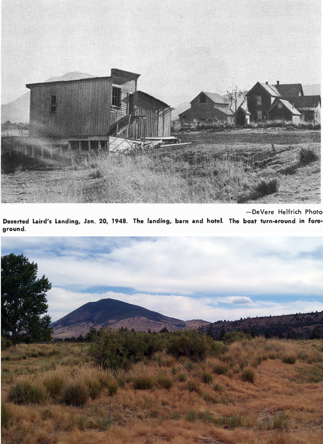
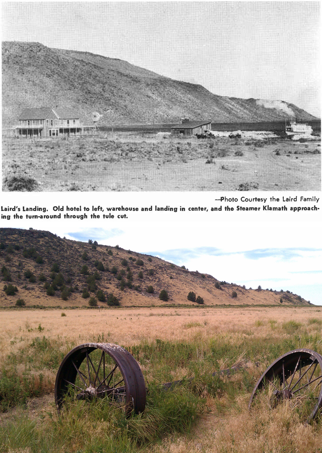
Formerly a stopping place on the old wagon road from the Tule Lake-Merrill country to Shasta Valley points, especially Montague, Laird's was not opened to water traffic until the late summer of 1905. And then only after a channel was dredged from the open water of Lower Klamath Lake by the Adams dredge. Laird's Landing became the transfer point from the stages to boat, on the McCloud River railroad to Klamath Falls run. The Klamath did not commence on this run until October, 1905. The landing saw considerable freight traffic use for a few years also, or until the spring og 1908, when railroad had reached Mt. Hebron and Dorris and the traffic then went by way of Teeter's Landing.
Nothing remains of this former landing except the remaining evidence of the dredged out canal that allowed the steamboat Klamath to stop here to ferry passengers. I've uploaded a Google map with an arrow pointing to the former landing which can still be seen. There are no buildings or structures remaining here. There are only a few pieces of old agricultural equipment and some rusting cans and pieces of wood lying around. There is a mobile home that sits just south of the landing and on the spot where some old structures once existed as seen from a picture from the Echoes journal. There was once a hotel located just SW of the landing as well from another picture. What happened to the Lower Klamath Lake where the Klamath once ferried passengers? Well, around 1905, when the Klamath Water Act was passed, it allowed the construction of a huge network of irrigation canals that would provide water for farming and ranching, creating an agricultural boom in the Klamath Basin. That, along with a couple of Homestead Acts that followed, would encourage farmers and ranchers to settle in the Basin and stake their claims for new and fertile land to farm on. Lower Klamath Lake along with other lakes in the nearby area would shrink drastically in size and be replaced with irrigated farm lands whose water supply would then be managed by the Bureau of Reclamation. Over the decades, there has been much controversy concerning the water rights that farmers and ranchers claim they need for their lands and the environmental groups and establishments who argue the negative effects the managed waters have had on the wildlife and the environment. Before the Klamath Water Act, salmon runs would swim up Klamath River not far from here and spawn in Upper Klamath Lake. The large water bodies that once existed here would attract millions of bird species to the area. After the Water Act, dams were built in rivers throughout the Basin to channel water into canals for irrigation of millions of acres of new farmland and the salmon runs no longer pass through this area. Bird species that fly through this area are much smaller than they used to be. Fortunately, President Theodore Roosevelt created the nation's first National Wildlife Refuge and the Lower Klamath Lake National Wildlife Refuge which this former settlement sits on was the nation's first designated piece of land to be protected from any kind of development. Since that time there have been other wildlife refuges created in the area to include the Upper Klamath Lake National Wildlife Refuge, nearby Tulelake National Wildlife Refuge and Clear Lake National Wildlife Refuge. As for the steamboat Klamath, it ended up being relocated from Lower Klamath Lake to Upper Klamath Lake around 1910 and continued to ferry passengers for a number of years longer until it was retired in the early 1920s and then sat and rotted away into obscurity at the former Pelican Bay Lumber Co. close to where Pelican Marina now resides. I've uploaded pictures of the Klamath that shows the before and after, with a picture taken of it in 1948 in sad condition.
My posted coordinates are exactly on the Laird's Landing turnaround. The Parking and Access coordinates below are a good place to park and access this former settlement. There is a wooden fence that you can follow all the way to the landing. Have fun!
I located another website link that describes the history of this place here and it reads:
Steamboats on Klamath Lake
Shortly after 1900, transportation was needed between the railroad, in Siskiyou County , and Klamath Falls, Oregon. At this point a railroad followed the McCloud River to Bartle. From that point the "Bartle Fast Freight Road" was constructed to the southwestern corner of Lower Klamath Lake at Laird's Landing in 1905. This was the site of the ranch of Charlie Laird and family. A canal was dredged, and an 80 foot propeller-driven steam boat began service. People and merchandise rode the train to Bartle, took a stage to Laird's Landing and then the steamboat to Klamath Falls.
By 1906, the Weed Lumber Company had completed a railroad to Grass Lake. So the stage line was shifted to that point with daily service each way. In 1903, Abner Weed had built a three story hotel at Grass Lake to accommodate what he hoped would be an influx of tourists, as Grass Lake was full of water. This hotel was used as the stage station and railroad depot for the people changing modes of transportation.
When the railroad to Klamath Falls was completed in 1909, the staging of passengers to Laird's Landing came to an end, as did the need for a steamboat across the lake. The Grass Lake hotel. also fell into disuse and was eventually torn down in the late 1930's or early 1940's. Lairds Landing is gone, as is the vestige of the canal and dock.