
Varnum's Quarters (1711) - Valley Forge, PA
N 40° 06.205 W 075° 26.718
18T E 462046 N 4439330
Brigadier General James Mitchell Varnum arrived with his staff in December 1777. This arrival dramatically altered life in the Stephens house. Suddenly the three family members were sharing their home with seven strangers.
Waymark Code: WMGZ0W
Location: Pennsylvania, United States
Date Posted: 04/26/2013
Views: 4
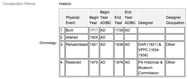
The Stephens family lived in this stone farmhouse built in a style reminiscent of Welsh architecture; with four rooms and an attic. On the upper floor would have been sleeping chambers and the lower floor the kitchen and parlor. It was here that David Stephens and his wife Elizabeth raised three children Eleanor, Maurice, and Abijah. By the time of the encampment the two older children were out of the house. At the time, the farm was 150 acres. I imagine the family wondered if their house would be confiscated but the General offered to pay rent and as soon as his hut was finished being built (I think it was in April) The seven men (including the General) moved out of the house.
The house is located on a footpath from the Valley Forge Road parking lot which is 455 feet west of the house @ N 40° 6.185 W 75° 26.812. After parking, proceed along the NPS paved trail and pass the  General Friedrich von Steuben Statue (419). The house will be just down a gentle slope, and along the right or south side of Valley Forge Road if traveling east. I visited this house on March 19, 2011 @ 11:57 AM, EDT, & @ an altitude of 185 feet ASL.
There is an interpretive that goes along with the house and reads:
When he moved in, General James Varnum used one room as both living quarters and brigade headquarters, and even held general courts martial. The owners, David and Elizabeth Stephens and their family, were allowed to remain in the rest of the house. A large portion of their farmland was used for the Grand Parade.
When Varnum’s hut was completed, he joined his Rhode Island and Connecticut brigades hutted on both sides of the road near Stephens’ home.
More About the Interpretive
The background of the marker features a picture of General Varnum and his officers in the Stephens house. The upper right of the marker contains a portrait of Brigadier General James Varnum, and below this is a layout of Varnum’s Quarters on the second floor of Stephens’ house.
General James Varnum of Rhode Island quartered with the David Stephens family for a period of the Valley Forge encampment. Their 18th century farmhouse has been restored and furnished to reflect the appearance at that time. Living history interpreters tell the story of how the Continental Army's encampment impacted local civilians. SOURCE The house is open 12 pm to 4 pm on Saturdays and Sundays, from September 2 to October 26 and then 9 am to 4 pm from October 27 to December 31. The house is closed for Thanksgiving, Christmas and New Year's Day.
Varnum's Quarters meets criterion A for its association with American Revolution and Criterion B for its association with George Washington and the impact of the encampment on his military career. PA SHPO concurrence 9/16/2004 to 2000 CLI that resource contributes to the national significance of Valley Forge NHP. The house is inventoried as structure no. 101.
From the Nomination Form:
Original structure dating to winter encampment of 1777-1778 & oldest known structure in Park. It was owned by wealthy farmer David Stephens who hosted Brig. Gen. James Mitchell Varnum. Fine example of early 18th c. farmhouse. Listed as contributing in CLI, with SHPO concurrence on 09/16/2004.
Short Physical Description:
2-story, 3 bay, 33'x22' "I" plan farmhouse w/ 2 stone & brick recessed end chimneys, in coursed, random-laid walls, gable roof covered in wood, squared corner quions, 22" thick walls at grade.
Long Physical Description:
N/A
My Sources
1.
NRHP Nomination Form
2.
National Park Service
3.
Historical Marker Database