
Petroglyph Point Archeological Site - Modoc County, CA
N 41° 50.720 W 121° 23.470
10T E 633563 N 4633854
Petroglyph Point is located in the Lava Beds National Monument just east of County Rd 126. Access via State Hwy 139, about 8 miles southeast of the small town of Tulelake.
Waymark Code: WMGW48
Location: California, United States
Date Posted: 04/14/2013
Views: 4
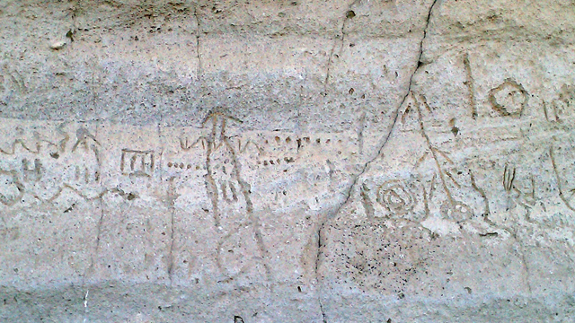
Text taken from the placard at Petroglyph Point:
For thousands of years, the hill rising in front of you was an island. Ancient Lake Modoc lapped against its base, scouring cliffs. Later, Native Americans canoed to these cliffs to carve symbols in the soft volcanic tuff, and Modocs still tell of Kamookumpts, creator of the world, who sleeps here.
As you walk along the base of the cliff, a trail brochure will guide you past petroglyphs and through stories of Petroglyph Point and the native peoples who have gone before and continue today.
_____________________________________________________
Its difficult to imagine just how monumental this cliffside feels unless you're standing before it. The cliff towers over you and shadows you in a cold breeze if you happen to visit in the morning. Also, pay attention to the petroglyphs in some areas and see the unfortunate additions of modern 'graffiti' added to the cliffs as well. These actions resulted in the Parks Service adding a fenceline along most of the cliffside to prevent people from destroying and damaging these historic drawings.
I didn't have the time to hike up to the point but there is a trail you can follow all the way to the top. Also, there are petroglyphs on the east side of the point as well (I didn't visit them).
On a final note, if you see this point on a topography map, it's listed as Prisoners Rock. This title derives from the Modoc War of 1872-3 and for which the Modoc natives who were marched out of the Captain Jack's Stronghold (where the majority of the Indian War was fought) were sent to the top of this point by the military as a stopover before they were then marched up to the Klamath Indian Reservation near Chiloquin, OR. There is some great history here if you look for it.