Indian Wells - Indian Wells, CA
N 33° 43.320 W 116° 20.268
11S E 561351 N 3731529
This historical monument and nearby historical placard are located in the Indian Wells City Hall complex in Indian Wells, CA.
Waymark Code: WMGR5Y
Location: California, United States
Date Posted: 04/03/2013
Views: 8
Tucked back, away from the busy Hwy 111 freeway and next to the Indian Wells City Hall parking lot are two historical monuments that highlight the history behind the naming of this township as 'Indian Wells'. There is a dark, metal plaque monumented on a boulder that reads:
INDIAN WELLS
HONORING THE MEMORY OF THE EARLY CAHUILLAN INDIAN CLANS WHO DUG THE INDIAN WELL 400 FEET BACK OF THIS MONUMENT, AND THE PIONEER SETTLERS, PROSPECTORS AND STAGE LINE PASSENGERS WHO CAMPED AT THE COUNTY WELL, LOCATED 50 FEET BACK OF THIS MONUMENT. THE COUNTY WELL, DUG IN 1870 AND USED UNTIL 1910 WAS FOR YEARS THE VALLEY'S ONLY COUNTY ESTABLISHED WATERING POINT.
ERECTED BY THE COACHELLA VALLEY PIONEER SOCIETY |
There is another plaque below that reads:
THIS HISTORICAL MONUMENT WAS RELOCATED FROM ITS PREVIOUS LOCATION ON THE NORTH SIDE OF HIGHWAY 111, APPROXIMATELY TWO MILES EAST OF THE DATE PRESERVE PARK. THE RIVERSIDE COUNTY HISTORICAL COMMISSION APPROVED THE PARK AS THE PERMANENT LOCATION FOR THE MONUMENT ON DECEMBER 23, 1985. THE ACTUAL RELOCATION OCCURRED IN NOVEMBER 1987. |
Finally, there is a white placard near the monument that discusses the history of Indian Wells and reads:
THE INDIAN WELL
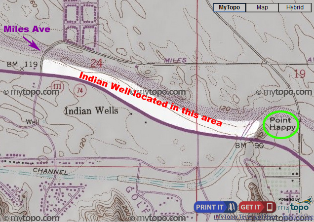
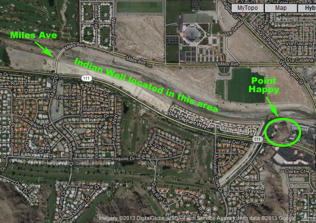
Floods and shifting sand dunes long ago obliterated the Indian well for which Indian Wells in named, and which was once the Cahuilla Indians' most reliable source of water. Probably located north of what is now Highway 111, between Miles Avenue and Point Happy, it looked more like a deep mining excavation than a traditional water well, and must have been dug over many, many years.
By 1853, when it was first seen and described by explorer William Blake, the "well" was a funnel-shaped pit with rock-hard clay walls and clay steps descending at least 25 feet into the earth. Blake guessed it had begun as a small seep--a spot where water oozed to the surface of the ground--which the Cahuilla gradually deepened by removing a little clay whenever the water level dropped too low. The staircase evolved as the depth of the pit increased, and, like the pit, was made entirely by hand.
The well was slow--the supply ran out before Blake had finished watering his mules--but steady and abundant. He collected 20 bucketsful in the course of the night. The well continued to supply pioneers and Indians with water for a good many years.
White settlement of the Coachella Valley eventually pushed the Cahuilla into the surrounding mountains and canyons. The Indian well was abandoned. By 1916, this "pozo hondo," or deep well, thought to be the oldest seep in the desert, had vanished under sand and debris.
_____________________________________________________
The below photos show the area where the former Indian Well would have existed. Half of the area is developed with homes, the other half is still desert. It would be a thrill to be able to locate the exact spot where this old watering hole once provided so many people water back in the day.