
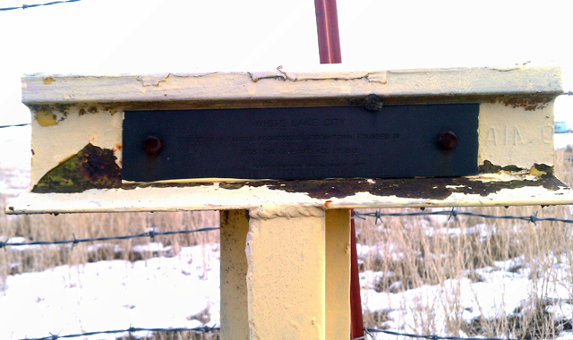
White Lake City - Klamath County, OR
N 42° 00.570 W 121° 38.666
10T E 612248 N 4651719
This historical 'T' marker is located along Lower Klamath Lake Rd in Klamath County, OR.
Waymark Code: WMGFRC
Location: Oregon, United States
Date Posted: 02/28/2013
Views: 1
This historical marker is part of a series of historical markers located all around Klamath and Jackson Counties and commissioned by both the Klamath County Historical Society and the Southern Oregon Historical Society.
This particular T-marker
The marker text reads:
WHITE LAKE CITY
SITE OF A FAMOUS PROMOTIONAL BOOM TOWN. FOUNDED IN
1905. OUT OF EXISTENCE BY 1918.
KLAMATH COUNTY HISTORICAL SOCIETY 1978
I've become somewhat of a local historian buff and have obtained a series of books titled Klamath Echoes that highlight the history of towns and settlements in and around the Great Klamath Basin and one particular book, Klamath Basin 1977, discusses the history behind White Lake City and reads:
In 1905 when the History of Central Oregon was published "there was only one 'dead town (Merganser -- Editor) in Klamath County." At the same time on the northern shores of White Lake barely inside Oregon, or one mile south and two miles west of the center of Merrill, Oregon, Klamath's newest boom town was in the process of springing into existance. White Lake City was named for the lake upon whose shores it was to flourish for a short time then pass into oblivion.
White Lake itself was so named because of the color of the lake bottom, which apparently consisted of some white diatomaceous material. The lake was a very shallow extension of the original Lower Klamath Lake system. A large percentage of the White Lake area was south of the Oregon-California State Line and therefore in California.
Beginning about 1903 with the completion of the Adams Tule cut from Lower Klamath Lake to White Lake and beyond as an irrigation system for the Merrill-Tul Lake country, boats were able to reach the lake and navigate most of its area. Merrill Landing was established at the extreme southeastern side of the lake through which a considerable amount of freight passed in early times. There seems also to have been a landing along the north shore of White Lake. At least a few years ago, two posts and a cross-piece of timber still remained of this little used landing.
Today, eliminated by irrigation and drainage projects, what was once White Lake is bisected by paved California Highway #161, "State Line Road," connecting U.S. Highways #139 and #97. White Lake City lay north of this road and north of the curving north shore of the lake. The nucleus of the town was in Section 16, Township 41 South, Range 10 East, the northeast corner lying one-half mile west of the junction of the Merrill Pit and Lower Klamath Lake Roads.
Visit Instructions:
Include your thoughts and observations pertaining to this location and your visit. Provide any additional history that you are aware of that pertains to this location. If the marker commemorates a historic building tell us what it is used for now or share with us the circumstances of an earlier visit to bring this locations history to life.
Please upload a favorite photograph you took of the waymark. Although visiting this waymark in person is the only thing required of you to receive credit for your visit, taking the time to add this information is greatly appreciated.
Be creative.