
The 3rd Maine Infantry served as a member of Ward’s Brigade in Birney’s Division of the Third Corps, Army of the Potomac, a Fighting 300 Regiment. The unit was commanded by Colonel Moses B. Lakeman (1828-1907). Lakeman took over the brigade on July 3rd, and Captain William C. Morgan took command of the regiment. The 3rd Maine was one of several regiments from Third Corps moved from a reserve position to the point of attack on July 3. The unit has 266 men engaed at Gettysburg with 18 killed, 59 wounded and 45 who went missing.
The 3rd Maine Infantry Flank Monument is just off of Route 15, part of the newly adopted Pennsylvania Byway system, 168 short of the southwest corner of the Peach Orchard.. Traveling south down Rt. 15, make a left on Birney Avenue. The monument is 238 feet off to the left or north side of the road (away from the Emmitsburg Road (Business U.S. 15 intersection, actually a "T"), directly to the right of the  3rd Maine Infantry Monument (MN177-D), which is 101 feet away to the northeast. The 3rd Michigan RIght Flank Monument is 2 feet away and both can be seen from GoogleEarth. Judging by the position of the main monument and the flank markers, it would appear the line of men were facing the west toward Confederate Avenue where the Rebel troops were massed to attack on July 3, 1863.
 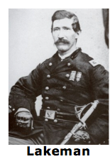 Parking is available at small, cutout shoulders along the road, some wide, some narrow. Be sure to stay off the grass or you will be tickete by park police. I visited this monument on Thursday, July 5, 2012 at 11:32 AM. I was at an elevation of 616 feet, ASL. I used my Canon PowerShot 14.1 Megapixel, SX210 IS digital camera for my photos.
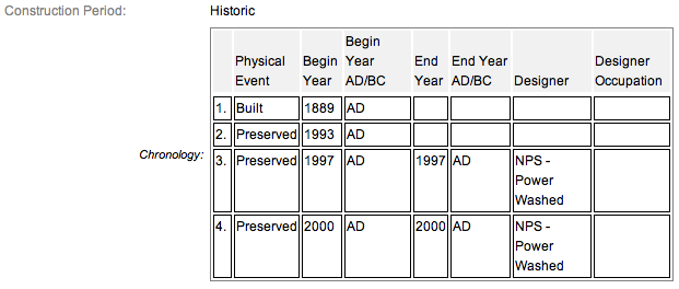
The primary 3rd Maine Infantry Monument (MN241-B) has two flanking markers, this one and another found way on the other side of the main monument, and two position markers. The monuments were all dedicated on October 23, 1889 by the State of Maine. All the monuments & markers are composed of granite. This flank monument is almost a perfect cube but it is a little more high (2 feet) than it is square its base (1 foot²), so I guess it is a rectangular prism. Additional details from the nomination form concerning the flank monuments may be found below in red. The inscription reads:

The 3rd Maine Infantry Monument & position markers are contributing feature to the Gettysburg National Military Park Historic District which is nationally significant under NR Criteria A, B, C & D. Areas of Significance: Military, Politics/Government, Landscape Architecture, Conservation, Archeology-Historic. Period of Significance: 1863-1938. The original National Register Nomination was approved by the Keeper March 19, 1975. An update to this nomination was approved by the Keeper on January 23, 2004. The monument and markers are identified as structures number MN177-D.
From the Nomination Form:
1 of 15 mns in Park honoring Maine commands. Marks where regiment was engaged on July 2, 1863, at SW corner of Peach Orchard. Pitzer Woods position marker on Berdan Av marks morning of July 2. E side of Hancock Ave marker marks regiment on July 3.
Short Physical Description:
Mn, 2 flank & 2 position markers. Mn: Rough-hewn base, 5'x5'x1'6" & tappering granite shaft, 2'6" sq 8'1" high, topped w/inverted Corps Diamond Lozenge. Polished inscription panels on N & S side of shaft Overall 13'1" high. Position markers, 2'x2'x2'. Flank markers, 1'x1'x2'.
Long Physical Description:
Monument that has two flanking markers and two position markers. Monument is a 2.6 foot tapering granite shaft that is 8.1 foot high and topped with an inverted 3rd Corps Diamond Lozenge set on a 5.5x1.6 foot rough hewn base. The shaft has polished inscription panels on the north and south sides. Overall height is 13.1 foot. Flanking markers are one foot square. Position markers are two foot square. Monument located at the southwest corner of the Peach Orchard. One position marker located in Pitzer Woods on Berdan Avenue and the other position marker is found on the east side of Hancock Avenue.
My Sources
1.
NRHP Nomination Form
2.
Draw the Sword
3.
Historical Marker Database