|
 First Shoupade - Cobb Co., GA Posted by:  Lat34North Lat34North
N 33° 50.199 W 084° 29.513
16S E 732089 N 3746873
Within Shoupade Park are the remains of the Civil War fortifications designed by Brig. Gen. Francis Shoup near the Chattahoochee River during the Atlanta Campaign. Gen. Sherman called it “the strongest field fortification he'd ever seen”.
Waymark Code: WMGD82
Location: Georgia, United States
Date Posted: 02/17/2013
Views: 1
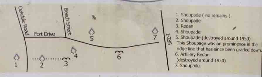
Map of Shoupade Park
First Shoupade
Before you are the earthen remains of a Civil War fort of unique design. Upon seeing these forts, Confederate Major General G. W. Smith said that their designer – Brigadier General Francis Shoup - would become famous, and Smith called them Shoupades. The name stuck, and we still call them Shoupades today.
This marker is behind the fort, near the opening that allowed access for soldiers. While each arrowhead-shaped Shoupade was similar in design, their dimensions could vary. The “standard” size was intended to hold as many as 80 men. Depending on the terrain, each fort was 60 to 175 yards from the next one. The Shoupades in this section of the river line were on a ridge, facing north.
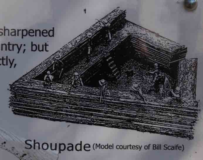
Each fort had inner and outer horizontal log walls, the outer walls rising 15 to 20 feet high (see illustration). The inner walls were not as high, and between the walls was packed earth on which the riflemen stood. What you see today is the earth that was between the log walls.
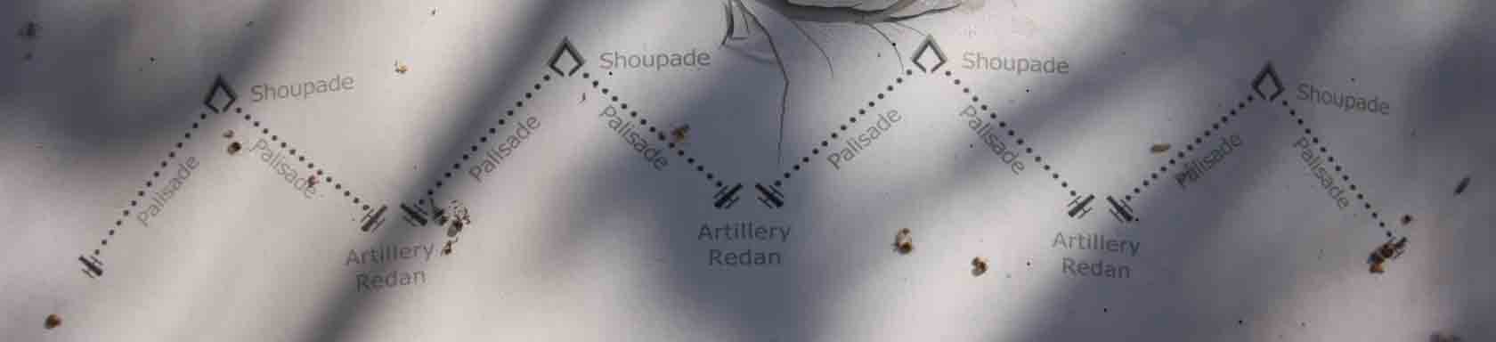
Between the Shoupades were palisades - sharpened logs standing vertically - defended by infantry; but rather than connecting the Shoupades directly, the palisades formed a reentrant angle, where an artillery redan held two guns. The objective was to channel any attack into areas that could be swept by both rifle and cannon fire.
To the right (east) of this Shoupade is a low line of earth leading to an artillery redan. This line is the remains of the base of the palisades.
This park is made possible by: The Cobb County Board of Commissioners, River Line Historic Area, Oakdale Community Association, Pulite Homes, Easlan Capital, & the Georgia Battlefield Association.
The park is located on the east side of Oakdale Rd. between Dunagan Dr. and Fort Dr., Smyrna, GA. There are four interpretative signs in the park and the remains of a section of the earthworks.
For more information on the history of Johnston's River Line:
Historic Markers
On-line:
Books:
The Chattahoochee River Line
An American Maginot
by William R. Scaife and William E. Erquitt
©1992
ISBN: 0-9619508-5-4
Hells´s Broke Loose in Georgia
Survival in a Civil War Regiment
by Scott Walker
©2005
ISBN: 978-0-8203-2605-04
Type of Marker: Fort

Marker #: None
Date: unknown
Sponsor: The Cobb County Board of Commissioners, River Line Historic Area, Oakdale Community Association, Pulite Homes, Easlan Capital, & the Georgia Battlefield Association
|
Visit Instructions:
Take a picture of the marker, yourself at the marker, your gps at the marker, or anything specific to the text on the marker. And don't forget to enjoy your visit.
|