
The 5th Corps, 1st Division, 2nd Brigade was also known as Sweitzer’s Brigade. During the battle of Gettysburg, it served as a member of Barnes’ Division in the Fifth Corps, Army of the Potomac. The brigade was commanded by Colonel Jacob Bowman Sweitzer (July 4, 1821 – November 9, 1881) was a Pennsylvania lawyer and soldier who commanded a regiment and then a brigade in the Army of the Potomac in the American Civil War. He and his men were significantly engaged at the 1863 Battle of Gettysburg, where they reinforced and helped temporarily stabilize the Union defensive line on the second day of fighting. Sweitzer was mustered out with his regiment on July 13, 1864. He received a brevet promotion to the rank of brigadier general for “war service” on March 13, 1865. After leaving the army, Sweitzer settled in Pittsburgh, Pennsylvania. He resumed legal practice in Pittsburgh. Sweitzer died on November 9, 1881, and was buried at Allegheney Cemetery.
The Sweitzer's Brigade - US Brigade Tablet is located just south of the intersection of DeTrobriand Avenue and Sickles Avenue, on the right when traveling east on DeTrobriand Avenue. 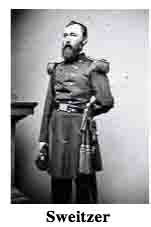 Parking is available on the side of the road at periodically enlarged shoulder cutouts. Be sure to keep vehicles off the grass or you will be ticketed by park police. I visited this monument on Thursday, July 5, 2012 at 2:06 P.M. I was at an elevation of 543 feet, ASL. I used a Canon PowerShot 14.1 Megapixel, SX210 IS digital camera for the photos.
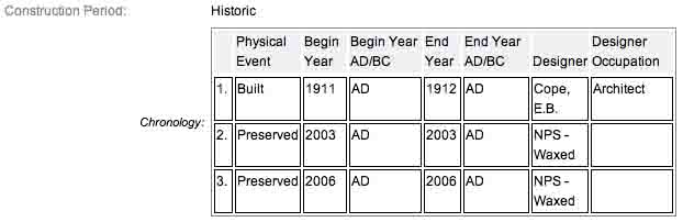
The monument work was done under the direction of the Gettysburg National Park Commission (established by the United States Department of War), after they took over the administration of the park from the Gettysburg Battlefield Memorial Association (whose funds had expired) on March 3, 1893, and whose stewardship was then transferred to the National Park Service in 1933) SOURCE. According to the NRHP narrative, this monument was built in 1911 but finished in 1912, which according to my experience is questionable. I can't resolve if the 1912 date represents a completion of the physical construction of the tablet or an installation date. Other sources have it at 1910 & 1912. I don't know if anyone actually kept exact records of when these things were installed.
Draw the Sword, with descriptive help from the NPS site, offers the following description: Monolith consisting of polished smooth sea-green granite pedestal with a square base. Base tapers to a smaller dimension at the tablet. On each pedestal is mounted a bronze inscription tablet describing the movements and actions of the unit. There is also a maltese cross atop of the tablet, before the inscription begins. This is the symbol of the V Corps.
One of 74 (or 75 depending who you listen to) Union brigade monuments erected at Gettysburg by the United States War Department to describe the movements and itinerary of each Union brigade of the Army of the Potomac. The monuments were designed by E.B. Cope. Many of the inscription tablets were made of bronze melted down from Civil War cannons. The inscription on this tablet reads:
 Army of the Potomac
Fifth Corps First Division
Second Brigade
Col. Jacob B. Sweitzer
9th. 32d. Massachusetts 4th. Michigan
62d. Pennsylvania Infantry
July 2 After 4 p.m. moved from the Baltimore Pike near Rock Creek with the Division left in front to support of Third Corps line. Third Brigade was detached to occupy Little Round Top and the Brigade crossed Plum Run followed by First Brigade and went into position on the edge of woods west of the Wheatfield facing partly toward the Rose House First Brigade on the right. Brig. Gen. Kershaw's supported by Brig. Gen. Semmes's Brigade having attacked this position and First Brigade having retired the Brigade retired across the Wheatfield Road and formed on the north side of the woods facing the road when by order of Brig. Gen. J. Barnes the Brigade advanced to the support of First Division Second Corps and engaged Brig. Gen. Anderson's Brigade at the stone wall at the south end of the Wheatfield but the supports on the right having given away the Brigade was attacked on the right and rear and it retired under a heavy fire to a line north of Little Round Top and there remained until the close of the battle.
Casualties. Killed 6 officers 61 men. Wounded 26 officers 213 men. Captured or missing 1 officer 120 men. Total 427.
There are hundreds of non-sculpted monumentation for the various Confederate States & Union units which fought at Gettysburg. There are about 10 different variations of tablets, markers & monoliths by my reckoning. Six designs represent brigade (2), division (2), corps (2), & army headquarters (2), each different in a subtle way so as to distinguish between armies. Battalion/battery/advance position markers & regimental monuments for U.S. Regulars & Confederate have their own distinct design (2), bringing the total to 10 designs at the battlefield. The bronze tablets were created by Albert Russell & Sons Co. of Newburyport, Mass. The granite bases which accompany the various tablets were created by the Van Amringe Company from Boston, Mass. The cast iron tablets were manufactured by Calvin Gilbert. The 1910 Gettysburg Commission report lists the awarded contracts to these companies (not Gilbert) for the tablets. All of these tablets were designed by architect Colonel Emmor Bradley Cope (July 23, 1834 - May 28, 1927). He designed pretty much every tablet for both the Union & Rebel armies, each one distinct, w/ several different varieties. He is buried in Evergreen Cemetery  in Gettysburg, as well he should be as this park and most of the things seen here today were designed by him and as such, are his legacy. These monuments were erected just after the turn of the century during the first & beginning of the second decade of the 20th century. Each one has since been preserved or restored at least twice since the turn of the 21st century. The plaques & tablets were erected by the Gettysburg Park Commission (established by the War Dept.). The Gettysburg Park Commission is also referred to as the Gettysburg National Military Park Commission or the Gettysburg National Park Commission, to clear up any confusions, especially my own.
On October 1, 1898, the Gettysburg National Park Commission in a letter to the Secretary of War set gave recommendations for continuing the task of organizing & progressing the work of the Gettysburg National Military Park. Every November they wrote their annual report which outlined the work of the GNPC for that year. The following is an excerpt from that report relevant to this waymark. The link at the end of the paragraph will take you to the entire report. The method of marking the positions of troops on this field, as approved by the War Department, is to place the principal tablet or monument of each command at the position occupied by the command in the main line of battle, and to mark the several important positions subsequently reached by each command in the course of the battle by subordinate and ancillary tablets, with appropriate brief inscriptions giving interesting details and occurrences and noting the day and hour as nearly as possible. SOURCE
Most of the Commission reports have been digitized and can be found HERE. The initial 1893 report up to & including 1921 can be found here. 1922 to 1926 are missing & have yet to be discovered. The years 1927 to 1933 were discovered in 1996 and are also included. To my knowledge this is the most comprehensive list of documents that illustrated the development and formation of the park.
Information about these specific types of monuments:
BRIGADE HEADQUARTERS MARKERS (FOR UNION & CONFEDERATE TABLETS)
Brigade Headquarters (and Confederate artillery battalions, equivalent to Union artillery brigades) are bronze tablets mounted at an angle on a stone pedestal. They are the most numerous headquarters at Gettysburg, with over 70 Union and over 60 Confederate examples on the field. Union headquarters are marked with their corps or service branch symbol (like a cross, clover or crescent moon), while Confederate headquarters are simply labeled "C.S.A.". There are seventy-four brigade markers at Gettysburg honoring the AOP’s various brigades. (Other sources say there are 75). They were built by Albert Russell & Sons Co. of Newburyport, Massachusetts and Charles Kappes. The pedestals consist of sea-green granite with a square 36” x 36” base; they weigh 3500 pounds. On each pedestal is mounted a bronze tablet with rounded corners weighing 300 pounds. There are sixty-four brigade markers honoring the Army of North Virginia's various brigades. They were built by Van Amringe Granite Company (pedestals), Albert Russell & Sons Co., Newburyport, Mass (tablets) and Charles Kappes (foundations). The last was completed in December 1910. The 1910 date is disputed by other sites listing the end dates as 1912. The monuments consist of red circular Maine granite bases 34 1/2 inches diameter and weighing 3,000 pounds. On each base is mounted a 300 pound bronze tablet. SOURCE & SOURCE
The Sweitzer's Brigade - US Brigade Tablet is a contributing feature to the Gettysburg Nat'l Military Park H.D. which is nationally significant under NR Criteria A, B, C & D. Areas of Significance: Military, Politics/Gov't, Landscape Architecture, Conservation, Archeology-Historic. Period of Significance: 1863-1938. The monument is designated as structure no. MN487.
From the Nomination Form:
1 of 75 US Brigade Tablets in Park. Records movement & itinerary of Sweitzer's Brigade during Battle of Gettysburg, July 1-3, 1863. Located on S side of DeTrobriand Ave. near the Wheatfield.
Short Physical Description:
Bronze inscription tablet, 4'x3'8", mounted on a slant face of sea-green granite monolith pedestal w/ round corners, 3'x3'. Square base tapers to tablet. Overall, 5'4" high.
Long Physical Description:
N/A
My Sources
1. NRHP Nomination Form
2. Stone Sentinels
3. Virtual Gettysburg
4. Draw the Sword
5. Historical Marker Database
6. Wikipedia