
Erb's Covered Bridge - Lititz, PA
N 40° 10.067 W 076° 14.634
18T E 394079 N 4447121
The Erb's Covered Bridge is a Burr arch-truss covered bridge that spans Hammer Creek in Lancaster County, Pennsylvania, United States. A county-owned and maintained bridge, its official designation is the Hammer Creek #1 Bridge.
Waymark Code: WMEWYF
Location: Pennsylvania, United States
Date Posted: 07/15/2012
Views: 4
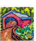
This covered bridge is a clone of the 25 other covered bridges (1 of them is white, the 27th bridge) with a white-painted portal and everything else on the outside & inside painted red, the traditional color of Lancaster County covered bridges. It is located on on Erb’s Road 3/4 mile north of Rothville on Picnic Woods Road in Warwick Twp. The surroundings are quite beautiful and peaceful. I spotted a family having a quiet picnic on their field. The bridge is a single lane deal so there is no room to walk safely inside. Parking is also a major issue. I parked southwest of the bridge, on the side of the road, half asphalt, half dirt-grass.
The covered bridge spans Hammer Creek and was originally built in 1849 by James G. Carpenter. The cost of the original bridge was $700. It was rebuilt by John G. Bowman in 1887 for $1744. So far, It has received no major flood damage despite some torrential downpours in the last couple of years. If you review recent videos of the bridge you can see where the creek rose to the floorboards a few times.
The bridge has a single span, wooden, double Burr arch trusses design with the addition of steel hanger rods. The deck is made from oak planks. The length of its largest span is 69.9 feet with the total length 76.1 feet. The width of the bridge is 13.1 and it has a vertical clearance of 11 feet 6 inches.. The bridge was added to the NRHP n December 10, 1980.
I also created a video which is hosted on YouTube of a walk-through I conducted of the covered bridge. I visited Keller's Mill Bridge on July 12, 2012 @ 12:14 PM. I used a Canon PowerShot 14.1 Megapixel, SX210 IS digital camera for the photos.