|
 Lower Hill Creek Falls - Falls of Hills Creek Scenic Area - Hillsboro, West Virginia
N 38° 10.304 W 080° 20.016
17S E 558371 N 4225079
The largest of the three Falls of Hills Creek and the reportedly second highest in the state of West Virginia is located off of State Routes 39/55 in Pocahontas County, West Virginia within the Monongahela National Forest.
Waymark Code: WMER5T
Location: West Virginia, United States
Date Posted: 06/30/2012
Views: 2
Lower Hill Creek Falls - Falls of Hills Creek Scenic Area - Hillsboro, West Virginia
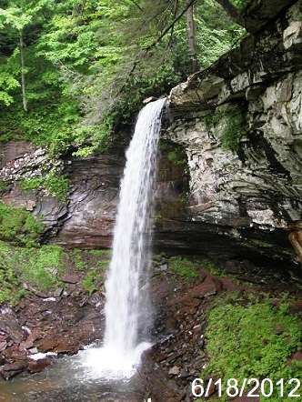
This is the largest of three waterfalls along Hills Creek, within the Falls of Hills Creek Scenic Area in the midst of the Monongahela National Forest in Pocahontas County, West Virginia. The area, is located off of of State Routes 39/55 between the communities of Richwood and Hillsboro.
This waterfall, a plunge type, descends from the rocks down 63 feet, reportedly making it the second tallest waterfall in West Virginia. The Lower Fall, is three-quarters of a mile from the parking area, which requires a walk down slippery steps and boardwalks to the falls.
The Scenic Area is open Daily May-October, Weekends only April and November, and is closed December-March
Accessible Vault Toilets are located in the parking area, and all disposable contents carried in must be carried out, as there are no refuse facilities in the Scenic Area.
Type: Plunge

Parking Coordinates: N 38° 10.680 W 080° 20.323
Watercourse: Hills Creek
Waterfall Height: 63
Seasonality: Seasonal
Seasons of Best Flow: From: 04/01/2012 To: 11/30/2012
Viewpoint: Bottom
Path Up and Down: Full
Walk Behind: Not at all
|
Recent Visits/Logs:
| There are no logs for this waymark yet. |
|
|
|
|