
Horton Trail - Seneca Creek Backcountry - Monongahala National Forest - Whitmer, West Virginia
N 38° 46.141 W 079° 33.594
17S E 625107 N 4292129
The Horton Trail is one of several trails accessible from County Route 29 in the Seneca Creek Backcountry in the Monongahela National Forest in Randolph County, West Virginia.
Waymark Code: WMER40
Location: West Virginia, United States
Date Posted: 06/30/2012
Views: 2
Horton Trail - Seneca Creek Backcountry - Monongahala National Forest - Western, West Virginia
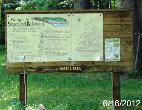
The Horton Trail, known as trail #530 follows Two Stream Run and goes over the top of Allegheny Mountain in the Seneca Creek Backcountry for three miles and connects with the Seneca Creek Trail. The trail was named for a settlement along Gandy Creek at the boom of the logging era of the 1900s. The Trail is surrounded by Hardwood Forests.
Parking is available at the trailhead
Trailhead/trail website: [Web Link]

Trail allowances or restrictions:
Hiking Only
Trail type: Dirt
Parking: Not Listed
|
Visit Instructions:
To claim a log for this waymark, some proof of a visit is required. This proof could be a simple photo of their GPS at the trailhead, a photo of the person at the trailhead, or a photo of a signature item that a person uses for photographs, at the trailhead.
In order to help other waymarkers who are looking for a nice hike/walk outdoors, you are encouraged to provide good feedback about the quality of the hike/trail.
Recent Visits/Logs:
| There are no logs for this waymark yet. |
|
|
|