
This Battery served in McIntosh’s Battalion which served as a member of the Artillery Reserve in the Third Corps, Army of Northern Virginia. The battery was commanded by Captain David Watson (1834-1864). Native of Louisa County. Mortally wounded at Spotsylvania.
The Watson’s 2nd Richmond Howitzers - CS Battery Marker is in across from Schultz woods and to the right os the National Guard Armory, on West Confederate Avenue, on the left or east side when traveling south; the marker faces the west. This area is Seminary Ridge near the Lutheran Theological Seminary. Parking is rather easy in this area as there are extra wide shoulders. Stay off the grass. There are many monuments and cannons in this area so expect to be here for at least 30 minutes or more to see everything. I visited this monument on Saturday, March 10, 2012 at approximately 11:26 PM, just before the clocks were set ahead for the Spring. I was at 527 feet ASL elevation.
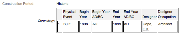
These monuments were first built in 1900 and concluded in 1906 according to the NRHP nomination form. This particular narrative has this monument at 1898 which given the history I have read, seems ridiculous. Some sites have the monuments being erected in 1910 or later. 1910 seems to be the most reasonable date so we will go with that. It is amazing with all the work and effort exerted to make the Gettysburg National Military Park a reality, no one took the time to keep accurate records and correct installation dates. The work was done under the direction of the Gettysburg National Park Commission (established by the United States Department of War), after they took over the administration of the park from the Gettysburg Battlefield Memorial Association (whose funds had expired) on March 3, 1893, and whose stewardship was then transferred to the National Park Service in 1933 SOURCE.
Draw the Sword, with descriptive help from the NPS site, offers the following description: Cast iron tablet, 3’8" x 3’4", with raised inscription painted in a contrasting color and mounted on fluted cast iron post. All 4’4" H. Tablets casts by Calvin Gilbert. The inscription on the 3.8' x 3.4' tablet narrates the events associated with Battery during the Battle. This particular marker is pretty beat up and faded. It looks as though it was repaired at one time although that information is not contained in the narrative with the exception of a 2002 entry which just says preserved. The inscription on the monument reads:
Army of Northern Virginia
Ewell's Corps Artillery Reserve
Dance's Battalion Watson's Battery
Second Richmond Howitzers
Four 10-pounder Parrotts
July 3 Moved to this position. Took part in the cannonade preceding Longstreet's final assault and continued firing for some time afterwards. Moved at night to the rear of this line.
July 4 In the night withdrew and began the march to Hagerstown.
Ammunition expended 661 rounds.
Losses not reported in detail
There are hundreds of non-sculpted monumentation for the various Confederate States & Union units which fought at Gettysburg, about 10 different variations of tablets, markers and monoliths by my reckoning. Six designs represent brigade (2), division (2), corps (2), & army headquarters (2), each different in a subtle way so as to distinguish between armies. Battery/advance position markers and regimental monuments for United States Regulars & Confederate have their own distinct design (2), bringing the total to ten deigns at the battlefield. Many of the tablets were created by Albert Russell & Sons Co. of Newburyport, Massachusetts and are made of granite, bronze and concrete or like this one, cast iron. All of these tablets were designed by architect Colonel Emmor Bradley Cope (July 23, 1834 - May 28, 1927). He designed pretty much every tablet for both the Union and Confederate armies, each one distinct, with several different varieties. He is buried in Evergreen Cemetery  in Gettysburg, as well as he should be as this park and most of the things seen here today were designed by him and as such, are his legacy. These monuments/tablets were erected just after the turn of the century during the first and beginning of the second decade of the 20th century. Each one has since been preserved or restored at least twice since the turn of the 21st century. The plaques and tablets were erected by the Gettysburg Park Commission (established by the War Department). The Gettysburg Park Commission is also referred to as the Gettysburg National Military Park Commission or the Gettysburg National Park Commission, to clear up any confusions, especially my own.
On October 1, 1898, the Gettysburg National Park Commission in a letter to the Secretary of War set gave recommendations for continuing the task of organizing and progressing the work of the Gettysburg National Military Park. Every November they wrote their annual report which outlined the work of the GNPC for that year. The following is an excerpt from that report relevant to this waymark. The link at the end of the paragraph will take you to the entire report. The method of marking the positions of troops on this field, as approved by the War Department, is to place the principal tablet or monument of each command at the position occupied by the command in the main line of battle, and to mark the several important positions subsequently reached by each command in the course of the battle by subordinate and ancillary tablets, with appropriate brief inscriptions giving interesting details and occurrences and noting the day and hour as nearly as possible. SOURCE
Most of the Commission reports have been digitized and can be found HERE. The initial 1893 report up to and including 1921 can be found here. 1922 to 1926 are missing and have yet to be discovered. The years 1927 to 1933 were discovered in 1996 and are also included. To my knowledge this is the most comprehensive list of documents that illustrated the development and formation of the park.
Information about these specific types of monuments:
CONFEDERATE BATTERY AND BRIGADE TABLETS (ADVANCED POSITION)
These tablets are 3’8" x 3’4" in dimensions, with carefully prepared inscriptions cast in raised letters painted in white (contrasting the black background) describing the part taken in the battle by each brigade, their position and stating its numbers and losses so far as practicable to obtain. They are mounted on iron pillars or fluted cast iron posts about 3 feet high, grouted in the ground, and the tablets are inclined at a suitable angle so that the inscriptions can easily be read by persons riding or driving on the avenue. Every tablet is 4’4" in height. The advance position markers were cast by Calvin Gilbert. SOURCE & SOURCE. These tablets usually have accompanying artillery pieces which flank the tablet on either side. There can be as little as one cannon and as many as four. The cannons usually represent the battery and the armaments that specific battery used at Gettysburg. The cannons presumably point in the same direction as they once fired at the enemy in 1863. Sometimes only the cannon pads are present as the guns are periodically removed for service, cleaning, restoration, maintenance, etc.
The Watson’s 2nd Richmond Howitzers - CS Battery Marker is a contributing feature to the Gettysburg National Military Park Historic District which is nationally significant under NR Criteria A, B, C & D. Areas of Significance: Military, Politics/Government, Landscape Architecture, Conservation, Archeology-Historic. Period of Significance: 1863-1938. The original National Register Nomination was approved by the Keeper March 19, 1975. An update to this nomination was approved by the Keeper on January 23, 2004. The monument is identified as structure number MN602-B
From the Nomination Form:
Civil War tablet that marks position of Watson's CS Battery on July 3-4, 1863. Narrates events associated w/ Battery during Battle of Gettysburg.
Short Physical Description:
MN & 2 Cannons. Cast iron tablet, 3'8" x 3'4", with raised inscription painted in a contrasting color and mounted on fluted cast iron post. All 4'4" H. Cast by C. Gilbert. Cannon on N/S side of tablet.
Long Physical Description:
Located on E side of West Confederate Avenue, opposite Shultz Woods. Only carriages remain on the north and south of the tablet.
My Sources
1.
NRHP Nomination Form
2.
Stone Sentinels
3.
Virtual Gettysburg
4.
Draw the Sword
5.
Historical Marker Database