
Kemper’s Brigade served as a member of Pickett’s Division in the First Corps, Army of Northern Virginia. This Virginian infantry was commanded by Brigadier General Lewis Addison Armistead (February 18, 1817 – July 5, 1863) who was a Confederate brigadier general in the American Civil War. He was wounded, captured, and died after Pickett's Charge at the Battle of Gettysburg.
The Armistead's Brigade - CS Brigade Tablet is located on West Confederate Avenue, on the right or west side if traveling south south along the avenue, 609 feet south of the Virginia State Memorial.. This area is called Spangler Woods. The monument faces an easterly direction.  Parking can be had at the side of the road at small, intermittently placed cutouts. Please do not park on the grass, park on the side of the road. I cannot emphasize that enough! You will be ticketed. I visited this monument on Saturday, March 10, 2012 at 2:18 PM, just before the clocks were set ahead for the Spring. I was at an elevation of 568 foot ASL.
Draw the Sword reports the last of these monuments were completed on December 19, 1910. For some reason, the actual dates on when these things were installed are always murky. It is amazing with all the work and effort exerted to make the Gettysburg National Military Park a reality, no one took the time to keep accurate records and correct installation dates. The work was done under the direction of the Gettysburg National Park Commission (established by the United States Department of War), after they took over the administration of the park from the Gettysburg Battlefield Memorial Association (whose funds had expired) on March 3, 1893, and whose stewardship was then transferred to the National Park Service in 1933) SOURCE.
Draw the Sword, with descriptive help from the NPS site, offers the following description: Monolith consisting of polished smooth red Maine granite pedestal with a circular base. On each pedestal is mounted a bronze inscription tablet describing the movements and actions of the unit. The base is 3.8 feet x 3.4 feet in diameter with a height of 5’4". The tablet measures 4 feet by 3 feet 8 inches and weighs 300 pounds with the overall weight at 3000 pounds. The tablet was constructed by Albert Russell & Sons Co. of Newburyport, Massachusetts and erected by the United States War Department. The last part is sort of correct, the Gettysburg Military Park Commission, created by the War Department actually had their workers install the monuments.
One of 64 Confederate brigade monuments. Designed by E. B. Cope and erected by the U.S. War Department. They indicate the general location of the centers of the various Confederate brigades and artillery battalions during several phases of the battle. Some of the tablets were made from melted down Civil War cannon. The tablets describe the itinerary and movements of each brigade. Erected circa 1910. The last monument was completed on December 19, 1910. The inscription on this tablet reads:
 Army of Northern Virginia
Longstreet's Corps Pickett's Division
Armistead's Brigade
9th. 14th. 38th. 53rd. 57th. Virginia Infantry
July 2 Arrived about sunset and bivouacked on the western border of Spangler's Woods.
July 3 In the forenoon formed line behind Kemper and Garnett east of the Woods. When the cannonade ceased advanced to support Kemper's and Garnett's Brigades forming the right of Longstreet's Column. Its losses being less at first than those of the other Brigades it passed the Emmitsburg road in compact ranks and as the front line was going to pieces near the stone wall pushed forward and many of its men and some from other commands responding to the call and following Gen. L.A. Armistead sprang over the wall into the Angle and continued the desperate struggle until he fell mortally wounded beyond the stone wall.
July 4 Spent the day in reorganization and during the night began the march to Hagerstown.
Present 1850. Killed 88, wounded 460, missing 643. Total 1191.
There are hundreds of non-sculpted monumentation for the various Confederate States & Union units which fought at Gettysburg, about 10 different variations of tablets, markers and monoliths by my reckoning. Six designs represent brigade (2), division (2), corps (2), & army headquarters (2), each different in a subtle way so as to distinguish between armies. Battery/advance position markers and regimental monuments for United States Regulars & Confederate have their own distinct design (2), bringing the total to ten deigns at the battlefield. Many of the tablets were created by Albert Russell & Sons Co. of Newburyport, Massachusetts and are made of granite, bronze and concrete or like this one, cast iron. All of these tablets were designed by architect Colonel Emmor Bradley Cope (July 23, 1834 - May 28, 1927). He designed pretty much every tablet for both the Union and Confederate armies, each one distinct, with several different varieties. He is buried in Evergreen Cemetery  in Gettysburg, as well as he should be as this park and most of the things seen here today were designed by him and as such, are his legacy. These monuments/tablets were erected just after the turn of the century during the first and beginning of the second decade of the 20th century. Each one has since been preserved or restored at least twice since the turn of the 21st century. The plaques and tablets were erected by the Gettysburg Park Commission (established by the War Department). The Gettysburg Park Commission is also referred to as the Gettysburg National Military Park Commission or the Gettysburg National Park Commission, to clear up any confusions, especially my own.
On October 1, 1898, the Gettysburg National Park Commission in a letter to the Secretary of War set gave recommendations for continuing the task of organizing and progressing the work of the Gettysburg National Military Park. Every November they wrote their annual report which outlined the work of the GNPC for that year. The following is an excerpt from that report relevant to this waymark. The link at the end of the paragraph will take you to the entire report. The method of marking the positions of troops on this field, as approved by the War Department, is to place the principal tablet or monument of each command at the position occupied by the command in the main line of battle, and to mark the several important positions subsequently reached by each command in the course of the battle by subordinate and ancillary tablets, with appropriate brief inscriptions giving interesting details and occurrences and noting the day and hour as nearly as possible. SOURCE
Most of the Commission reports have been digitized and can be found HERE. The initial 1893 report up to and including 1921 can be found here. 1922 to 1926 are missing and have yet to be discovered. The years 1927 to 1933 were discovered in 1996 and are also included. To my knowledge this is the most comprehensive list of documents that illustrated the development and formation of the park.
Information about these specific types of monuments:
BRIGADE HEADQUARTERS MARKERS (FOR UNION & CONFEDERATE TABLETS)
Brigade Headquarters (and Confederate artillery battalions, equivalent to Union artillery brigades) are bronze tablets mounted at an angle on a stone pedestal. They are the most numerous headquarters at Gettysburg, with over 70 Union and over 60 Confederate examples on the field. Union headquarters are marked with their corps or service branch symbol (like a cross, clover or crescent moon), while Confederate headquarters are simply labeled "C.S.A.". There are seventy-four brigade markers at Gettysburg honoring the AOP’s various brigades. (Other sources say there are 75). They were built by Albert Russell & Sons Co. of Newburyport, Massachusetts and Charles Kappes. The pedestals consist of sea-green granite with a square 36” x 36” base; they weigh 3500 pounds. On each pedestal is mounted a bronze tablet with rounded corners weighing 300 pounds. There are sixty-four brigade markers honoring the Army of North Virginia's various brigades. They were built by Van Amringe Granite Company (pedestals), Albert Russell & Sons Co., Newburyport, Mass (tablets) and Charles Kappes (foundations). The last was completed in December 1910. The 1910 date is disputed by other sites listing the end dates as 1912. The monuments consist of red circular Maine granite bases 34 1/2 inches diameter and weighing 3,000 pounds. On each base is mounted a 300 pound bronze tablet. SOURCE & SOURCE
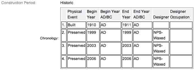
The Armistead's Brigade - CS Brigade Tablet is a contributing feature to the Gettysburg National Military Park Historic District which is nationally significant under NR Criteria A, B, C & D. Areas of Significance: Military, Politics/Government, Landscape Architecture, Conservation, Archeology-Historic. Period of Significance: 1863-1938. The original National Register Nomination was approved by the Keeper March 19, 1975. An update to this nomination was approved by the Keeper on January 23, 2004. The monument is identified as structure number MN698.
From the Nomination Form:
1 of 64 CS Brigade Tablets in Park. Records movement & itinerary of Armistead's Brigade during Battle of Gettysburg, July 3, 1863. Located on W side of West Confederate Ave, at Spangler Woods, south of Virginia State Memorial.
Short Physical Description:
Bronze inscription tablet, 3'8"x3'4", mounted at a slant on circular, polished pedistal, 6'4" in circumference, 5'4" high.
Long Physical Description:
There are 64 of these bronze inscription tablets, mounted on cylindrical polished granite pedestals. They indicate the general location of the centers of the various Confederate brigades and artillery battalions during several phases of the battle. Designed by E. B. Cope. Some of the tablets were made from melted down Civil War cannon. The tablets are 3.8 feet x 3.4 feet in dimension and rest on bases that are 6.4 feet in circumference. The overall height of these markers is 5.4 feet, and they rest on either rubble or concrete foundations.
My Sources
1.
NRHP Nomination Form
2.
Stone Sentinels
3.
Virtual Gettysburg
4.
Draw the Sword
5.
Historical Marker Database
6.
Wikipedia