
Anderson’s Division served as a member of Hill’s Corps in the Army of Northern Virginia. The Division was commanded by Richard Heron Anderson (October 7, 1821 – June 26, 1879), a career U.S. Army officer, fighting with distinction in the Mexican-American War. He also served as a Confederate general during the American Civil War, fighting in the Eastern Theater of the conflict and most notably during the 1864 Battle of Spotsylvania Court House. Anderson was also noted for his humility.
Anderson's CS Division Tablet is located 13 feet off of West Confederate Avenue, on the right or northwest side if traveling southwest, north of Pitzer Woods.  The monument faces southeast. Parking is tricky around here so exercise caution. Please do not park on the grass, park on the side of the road. I cannot emphasize that enough! You will be ticketed. I visited this monument on Saturday, March 10, 2012 at 2:43 PM, just before the clocks were set ahead for the Spring. I was at a 539 foot ASL elevation.
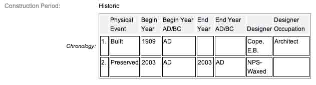
These monuments were first built around 1907 and concluded in approximately 1909 according to the NRHP nomination form and other sites. One site has the monument being erected in 1907; the NRHP also has it at 1909. It is amazing with all the work and effort exerted to make the Gettysburg National Military Park a reality, no one took the time to keep accurate records and correct installation dates. The work was done under the direction of the Gettysburg National Park Commission (established by the United States Department of War), after they took over the administration of the park from the Gettysburg Battlefield Memorial Association (whose funds had expired) on March 3, 1893, and whose stewardship was then transferred to the National Park Service in 1933) SOURCE.
Draw the Sword, with descriptive help from the NPS site, offers the following description: Monument is a rock-faced granite monolith with polished face on which is affixed a bronze narrative tablet.
One of ten Confederate division monuments that describe the movements and itenirary of each division of the Army of Northern Virginia. The locations of the markers indicate the general location of the battle lines of the various Confederate divisions during the battle.
 Army of Northern Virginia
Third Army Corps
Anderson's Division Major Gen. R.H. Anderson
Wilcox's Brigade Brig. Gen. Cadums M Wilcox
Mahone's Brigade Brig. Gen. William Mahone
Wright's Brigade Brig. Gen. A.R. Wright, Col. William Gibson
Perry's Brigade Col. David Lang
Posey's Brigade Brig. Gen. Carnot Posey
Artillery Battalion, Three Batteries, Major John Lane
July 1. Anderson's Division on the march to Gettysburg was directed about dark to occupy the position vacated by Heth's Division and to send a Brigade and Battery a mile or more to the right.
July 2. In the morning a new line of battle formed extending further to the right. About noon Longstreet's Corps placed on the right nearly at right angles to the line directed to assault the Union left the Division to advance as the attack processed to keep in touch with the Longstreet's left. The Union troops were forced from the first line and a portion of the ridge beyond. Union re-inforcements pressing on the right flank which had become disconnected from McLaws's left made the position gained untenable. The Brigades withdrew to their position in line.
July 3. The Division remained in position until 3.30 p.m. Orders were given to support Lieut. Gen. Longstreet's attack on the Union centre. Wilcox and Perry moved forward. The assault failed the order to advance was countermanded.
July 4. The Division after dark took up the line of march.
Casualties killed 147, wounded 1128, missing 840, total 2115.
There are nine different variations of similar monuments (not including the inverted canons which signal headquarters) for the various Confederate States & Union brigades/batteries/divisions which fought at Gettysburg. Four designs represent brigade, division, corps and army headquarters, and each has elements which identify it as Union or Confederate. Many of the tablets were created by Albert Russell & Sons Co. of Newburyport, Massachusetts and are made of granite, bronze and concrete or like this one, cast iron. All of these tablets were designed by architect E.B. Cope. He designed pretty much every tablet for both the Union and Confederate armies, each one distinct, with several different varieties. The monuments were erected just after the turn of the century during the first and beginning of the second decade of the 20th century. Each one has since been preserved or restored at least twice since the turn of the 21st century. The plaques and tablets were erected by the Gettysburg Park Commission (established by the War Department). The Gettysburg Park Commission is also referred to as the Gettysburg National Military Park Commission or the Gettysburg National Park Commission, to clear up any confusions, especially my own.
On October 1, 1898, the Gettysburg National Park Commission in a letter to the Secretary of War set gave recommendations for continuing the task of organizing and progressing the work of the Gettysburg National Military Park. Every November they wrote their annual report which outlined the work of the GNPC for that year. The following is an excerpt from that report relevant to this waymark. The link at the end of the paragraph will take you to the entire report. The method of marking the positions of troops on this field, as approved by the War Department, is to place the principal tablet or monument of each command at the position occupied by the command in the main line of battle, and to mark the several important positions subsequently reached by each command in the course of the battle by subordinate and ancillary tablets, with appropriate brief inscriptions giving interesting details and occurrences and noting the day and hour as nearly as possible. SOURCE
Information about these specific types of monuments:
DIVISION HEADQUARTERS MARKER
Division headquarters are rectangular bronze tablets mounted on large, rectangular stones. Union headquarters have a corps or service branch symbol (like a cross, clover or crescent moon) as a separate bronze piece above the tablet, while Confederate headquarters are labeled "C.S.A." on a separate bronze piece in an oval. There are 22 Union and 10 Confederate Division markers at Gettysburg. Both markers are of similar design and were all construed of Winnsboro (S.C.), granite. Each stands seven feet in height. SOURCE & SOURCE
The Anderson's Division - CS Division Tablet is a contributing feature to the Gettysburg National Military Park Historic District which is nationally significant under NR Criteria A, B, C & D. Areas of Significance: Military, Politics/Government, Landscape Architecture, Conservation, Archeology-Historic. Period of Significance: 1863-1938. The original National Register Nomination was approved by the Keeper March 19, 1975. An update to this nomination was approved by the Keeper on January 23, 2004. The monument is identified as structure number MN763.
From the Nomination Form:
1 of 10 CS Division Tablets in Park. Marks the command position of Anderson's Division during Battle of Gettysburg, July 1-3, 1863. Located on W side of West Confederate Ave, N of Berdan Ave.
Short Physical Description:
Rough-hewn monolith, 4'2"x2', 7' high. Bronze inscription tablet, 3'8"x3'6", mounted on polished face. Bronze oval plate inscribed "C.S.A." in raised letters.
Long Physical Description:
These 10 monuments consist of a rock-faced granite monolith with polished face on which is affixed a bronze narrative tablet. The locations of the markers indicate the general location of the battle lines of the various Confederate divisions during the battle. Designed by E. B. Cope. 4.2 feet x 2.0 feet, with an overall height of 7.0 feet.
My Sources
1.
NRHP Nomination Form
2.
Stone Sentinels
3.
Virtual Gettysburg
4.
Draw the Sword
5.
Historical Marker Database
6.
Wikipedia